D station - Prestreljenik
Starting point: D station (2202 m)
| Lat/Lon: | 46,3326°N 13,5384°E |
| |
Time of walking: 45 min
Difficulty: partly demanding marked way
Altitude difference: 297 m
Altitude difference po putu: 297 m
Map: Julijske Alpe - zahodni del 1:50.000
Recommended equipment (summer):
Recommended equipment (winter): ice axe, crampons
Views: 38.700
 | 5 people like this post |
Access to the starting point:
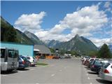
From Kranjska Gora, take the Vršič Pass or the Rateč Pass into Itali and over the Predel Pass to Bovec, or a little further along the main road to the lower station of the cable car to Kanin. From the Primorska side, first drive into the valley of the Soča River and then pass through Tolmin and Kobarid to Bovec. The price of a return cable car ticket is 13 € (July 2009). In the summer season (July, August) it runs every full hour, starting at 7:00 am. The last ride from station D to the valley is at 17:00.
Path description:
A few steps up to the right of Station D, there is a signpost on a rock on the ground that reads "Rombon". Walk in this direction to the bottom station of the four-seater Prevala, then walk alongside it for a few minutes to its intermediate station, where you turn left at the crossroads just before it (straight down Rombon and Prevala). The path runs along a steep slope the whole way, and is a little exposed in places. Considerable caution is needed due to the debris on the path, which makes slipping more likely on the steep parts. The trail continues slowly to the eastern side of the mountain, climbs steeper and becomes slightly more difficult in places. In a few places you have to help yourself a bit with your hands, there is no fixed safety gear. Just below the top, we come across the first, short, but currently (July 2009) broken off lower part, and right after it the next one, which probably needs some "servicing". In this area, there is also a wedge visible in one place, which is supposed to help with the climb, but beware - it is not fixed, but just stuck between the rocks! We climb up the increasingly scenic slope and after less than an hour's walk we reach the top.
On the summit stands a miniature replica of the Aljaž Tower, built by the Slovenian Mountaineering Club Skala. There is a registration book in the tower. The summit is quite spacious and the views from the top are very beautiful, as you can see everything from the Julian Mountains to Dolomites, High Tauern and the Adriatic Sea.

We can extend the trip to the following destinations: Prestreljenik
Pictures:
 1
1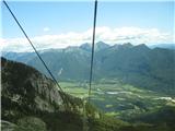 2
2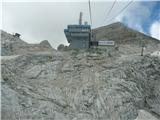 3
3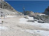 4
4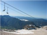 5
5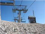 6
6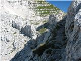 7
7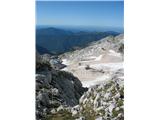 8
8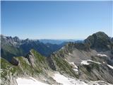 9
9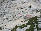 10
10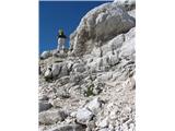 11
11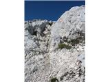 12
12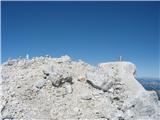 13
13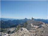 14
14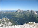 15
15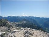 16
16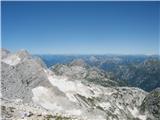 17
17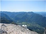 18
18
Discussion about the trail D station - Prestreljenik
|
| andrej76730. 07. 2007 |
Stolp je res kul,če ga s "prave" strani fotkaš bi marsikoga lahko potegnu da si bil na Triglavu ... 
|
|
|
|
| Snowfreak24. 06. 2008 |
Zdravo! Jutri (25.6.08) nacrtujemo izlet na Prestreljenik. Ve kdo, koliko je se snega na poti? Hvala in lp 
|
|
|
|
| Klin24. 06. 2008 |
Od kje pa načrtujete vzpon? V kolikor sem pravilno obveščen začne žičnica voziti v soboto 28.6.
|
|
|
|
| Snowfreak24. 06. 2008 |
aha... Ja plan je bil iz D postaje. S tem, da če zajla ne dela, potem se bomo pa verjetno kam drugam odpravili. Od B-ja je pa kar dolga.
|
|
|
|
| mitjasa9. 08. 2009 |
včeraj sem bil na vrhu, in pod vrhom so obe jeklenice in klin NE uporabni. Lepo je varovana pot tik pod vrhom obleganega okna. Lp
|
|
|
|
| petruša23. 08. 2009 |
bili smo z otroki 9 in 10 let gori, pot je zelo lepa, ko se vračate še ite pogledat okno, zelo zanimivo za otroke
|
|
|
|
| damijanp25. 08. 2009 |
Petruša, očitno smo dopustovali na istem koncu v podobnem terminu (glej tudi komentar pri Mangartu). Slike so na: Prestreljenik
|
|
|
|
| petruša27. 08. 2009 |
mi smo dopustovali v Trenti od 8.8.-17.8.2009, očitno pa da smo obiskovali podobne gore, primerne za naše otroke, no mi smo bili tudi na triglavi iz Zadnjice
|
|
|
|
| damijanp27. 08. 2009 |
Mi smo bili v Kalu-Koritnici od 15. do 22.8. Mogoče se pa vidimo kdaj drugič. 
|
|
|
|
| petruša27. 08. 2009 |
res mogoče pa drugo leto, od kod pa ste doma, mi smo iz okolice Ormoža
|
|
|
|
| petruša27. 08. 2009 |
po slikah sem vidla da ste bili tudi na Svinjaku, ker mi smo tudi bili, in niti nismo daleč en od drugih doma
|
|
|
|
| NaaN3. 08. 2012 |
Kako zahtevna in časovno dolga (našel sem samo podatek, da naj bi trajala 3h, kar se mi zdi nerealno) je pot s postaje D do Prestreljeniškega okna? S koliko starimi otroci ste hodili po tej poti?
|
|
|
|
| aljoša112. 06. 2017 |
Od začetka meseca junija dalje se žig od Prestreljenika nahaja v TIC-u Bovec.
|
|
|
|
| papillon6. 07. 2017 |
Je bil zdaj kdo gor, lahko pove, kakšno je stanje jeklenic in klinov na tej poti?
|
|
|
|
| 75'er6. 07. 2017 |
Za dostop do Prestreljenika ne potrebuješ nobenega klina ali jeklenice..
|
|
|
|
| Mundek20. 07. 2020 |
Žig od Prestreljenika se nahaja v Ski Bum baru na Kaninu (pri gondoli). Danes sem obiskal Prestreljenik in tam dobil žig. Lp
|
|
|
|
| Berstuk4. 08. 2020 |
Kaj je žig še v TIC-u? Žalostno je videt polomljen stolp na vrhu :/
|
|
|
|
| nrhnrh10. 08. 2020 |
Od vmesne postaje sedežnice Prevala, je potrebno slediti oznakam za ferato do table, ki označuje začetek ferate in težavnost. Tam nadaljuješ desno po markirani poti!
Drugih oznak za Prestreljenik ni bilo opaziti. Precej ljudi je zavedla oznaka za ferato in so iskali drugo pot. Nekaj se jih je podalo tudi v brezpotje.
|
|
|