Dom Trilobit - Weinasch/Vajnež (via Skalaška pot)
Starting point: Dom Trilobit (939 m)
| Lat/Lon: | 46,4579°N 14,1031°E |
| |
Name of path: via Skalaška pot
Time of walking: 4 h
Difficulty: very difficult unmarked way
Altitude difference: 1165 m
Altitude difference po putu: 1165 m
Map: Karavanke - osrednji del 1:50.000
Recommended equipment (summer): helmet
Recommended equipment (winter): helmet, ice axe, crampons
Views: 17.183
 | 5 people like this post |
Access to the starting point:
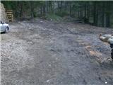
From the motorway Ljubljana - Jesenice take the exit Lipce and turn right towards Jesenice. In the village of Javornik, at the first semaphorised junction, turn right (direction Lj. ) towards Koroška Bela. At the next traffic-light junction turn left, and soon turn left again towards Javornik Rovto. After a few kilometres of uphill driving (when we have already arrived in the village), the macadam road turns sharp left and heads straight towards Dom Trilobit (signposted). After a few 100 m, we reach the lake, along which the road runs, and on the left we see Dom Trilobit. When you pass this building, the road ends in the wods, and here is your starting point.
Path description:
On the left side of the starting point, the slightly ruined cart track leads uphill and you will find the first signpost. After a few minutes we see the cart track branch off to the right towards the mountain pasture of Stamara, and we continue straight on until the point where the path approaches the stream bed. Here cart track turns to the left and ends at the upper source of the Javornik stream or flows out into a forest path. It begins to climb steeply, first straight ahead, then winding through the forest. On the left you will see a monument with a fence, and after a 45-minute walk you will reach another monument (to a hunter) along the path, where there is a completely destroyed bench on the right. The slope eases a little and the path heads north to the left, where it passes through a mixed wood for a while. Here, on the right, we can first observe the Srednice scree scree, and then a view gradually opens up to the east towards the Rida amphitheatre. This can be seen in its entirety after the forest becomes lane of dwarf pines. A few more detours and we are already in the vicinity of mountain pasture Seč, where we find direction signs on a tree.
Continue just slightly right along a less distinct valley towards the boundary ridge to the north. When you reach it (the boundary stone), bear right to continue uphill between dwarf pines along the boundary ridge, where the path occasionally follows the right-hand edge. When you reach a fairly narrow part of the ridge, the more difficult part of the route begins, followed first by a steep rocky descent along the unprotected aluminium wire rope below. Then we find ourselves on an even narrower part of the ridge, where the path (first to the right) passes between and along dwarf pines. Soon there is a short descent again on very crumbly rocky terrain, and then the path gradually turns to the left side of the ridge, where it soon climbs steeply back to the top of the ridge along the aluminium rope. The exposure and difficulties continue unabated, and we find ourselves facing a third obstacle: the almost vertical chimney, equipped with the same rope and steel crampons. When you reach the top, the route follows the right-hand side of the ridge, where it climbs a little and then descends more steeply, and soon, along a similar rope, it also climbs very steeply in an easterly direction (beware of the wet terrain!). Towards the top of the climb, the path turns right, where later on you will find yourself between dwarf pines at the end of the Skalaška Trail. Continue along the top of the border ridge towards Malega Vrha, where the path with beautiful views leads to its summit. From here we continue in the same direction, still walking along the ridge path along the northern precipices of the Belščice River, which after a while eventually leads us to the vicinity of the notch west of Weinasch, which we climb in a few steps of further walking.

Pictures:
 1
1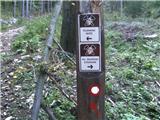 2
2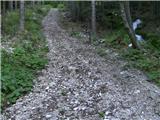 3
3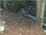 4
4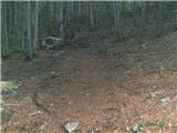 5
5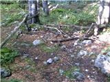 6
6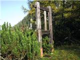 7
7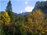 8
8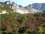 9
9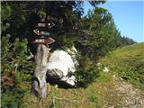 10
10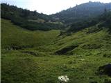 11
11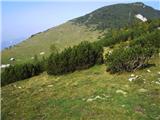 12
12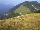 13
13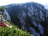 14
14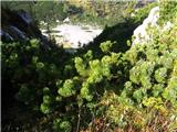 15
15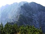 16
16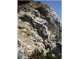 17
17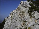 18
18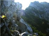 19
19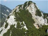 20
20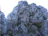 21
21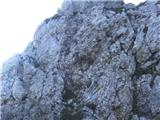 22
22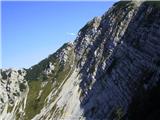 23
23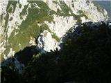 24
24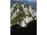 25
25 26
26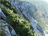 27
27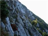 28
28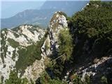 29
29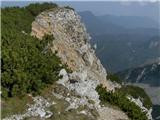 30
30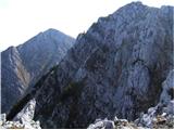 31
31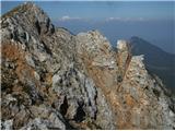 32
32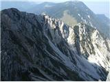 33
33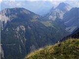 34
34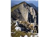 35
35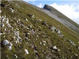 36
36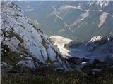 37
37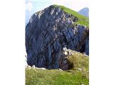 38
38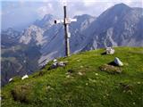 39
39
Discussion about the trail Dom Trilobit - Weinasch/Vajnež (via Skalaška pot)
|
| heinz29. 09. 2009 |
Kljub vrvem na štirih mestih Skalaške poti, bi se lahko reklo, da pot ni primerno varovana in zato (pa tudi zaradi vlažnosti), dokaj nevarna. Namenjena je zgolj planincem z zadostnimi izkušnjami hoje in plezanja po brezpotju. Ni za vrtoglave. Ostali del poti pa je lahkoten.
Srečno, Heinz!
|
|
|
|
| nata243. 07. 2010 |
Zanima me, če se stezi od planine Seče težko sledi ali je dobro uhojena?
|
|
|
|
| heinz3. 07. 2010 |
od Seč mejnega grebena ni težko najti(nekoliko desno od prvih lesenih tabel, po manj izraziti dolinici).Ko pridemo do mejnih kamnov zavijemo desno po mejni graničarski poseki (stezi). Vidna da, uhojena- tako /tako.. Ko pridemo na zahtevnejši del poti steze skorajda ni. Smer bi od tu dalje lahko uvrstili med zahtevna brezpotja. Orientacija nekoliko težavna.
..Ko enkrat dosežemo navpični del s skobami (imenovan je Viševnik), se ne povzpenjamo povsem do njegovega vrha, pač pa kot je navedeno v opisu, nadaljujemo po desni strani grebena najprej nekoliko navzgor, nato sledi spust po strmem terenu, kjer naletimo še na zadnjo vrv ob kateri se po vlažnem strmem terenu povzpnemo nekaj 10 m proti izteku skalaške poti.
Pot je krušljiva, v vodniku znanega avtorja pa označena kot -zelo zahtevna pot/ brezpotje.
Razmišljal sem tudi o tem, da bi administratorju predlagal spremembo težavnosti v "zelo zahtevno", kar dejansko tudi je.
Sicer pa kratka in pestra.
Še to: pozor na krušenje kamenja zaradi poti skozi Rido, ki poteka spodaj!
Sam sem na tem delu užival. Verjamem, da boste tudi vi!
Srečno, heinz!
|
|
|
|
| nata244. 07. 2010 |
Je šlo brez problema, pot našla, sem bila pa mokra in umazana do riti. Pri navpičnem delu je sedaj "ornk" jeklenica. Nadaljevala sem potem še do Potoškega Stola, videla celo 2 svizca in se vračala po spodnji markirani poti nazaj, ki se zelo vleeeeeeeče.Lp
|
|
|
|
| heinz4. 07. 2010 |
Ja spodnja se prvič kar malo vleče.
Pri katerem navpičnem delu; kjer so skobe, ali pri zadnjem vzponu, ki se konča med ruševjem? Jeklenice so bile svetle oz aluminijaste. Prva pa je bila spodaj prosta- s klinom izpuljena.
Kje si naletela na svizca? V Ridi?
|
|
|
|
| nata244. 07. 2010 |
Poleg tanjše jeklenice, kakršna je pri prvem spustu, je bila tam zraven še ena debelejša, ampak ne vem ali pri skobah ali na koncu (zgodnje vsatajanje ima očitno posledice). Svizca sem pa videla med skalami preden sem se povzpela na Potoški Stol.
|
|
|
|
| Majdag3. 09. 2011 |
...Dom Trilobit, Skalaška, Mali Vrh...Pa sem jo, to Skalaško, že celo poletje me mika. Čudoviti razgledi, enkratno. Nadaljevala na Mali Vrh, vračala pa sem se skozi Rido. Ni mi žal, super 
|
|
|
|
| green joga6. 01. 2012 |
A je bil kdo tuki v zadnjem času, da ve kake so kej zimske razmere?
|
|
|
|
| heinz7. 01. 2012 |
Popolne zimske razmere: sneg do pol metra, marsikje tudi več. V glavnem, po skalaški brez kompletne opreme ne bo šlo.
|
|
|
|
| ljubitelj gora20. 05. 2012 |
Šel danes tole pot in naprej proti Stolu, kot je heinz povedal v prvem komentarju, drugače je pot kopna.
|
|
|
|
| Metka Polpetka7. 07. 2014 |
Včeraj šla čez Skalaško. V ruševju pot dokaj zaraščena. Vse jeklenice držijo v zgornjem delu, ostalo je podrto. Spodnji dve skobi zelo razmajani, tretja zaenkrat še uporabna, tudi oprimki na tem mestu so dokaj razmajani. Škoda, ker tako razpada, ravno v tem ključnem delu bo kmalu vse na jeklenici, kateri pa nikoli ne moreš zaupati 100%, ker ne veš, v kakšnem stanju je zgoraj. Sicer pa čudovita, divja pot!
|
|
|
|
| heinz7. 07. 2014 |
Res, dokaj divja je ta Skalaška.. Če nihče ne bo poskrbel za adaptacijo, bo v prihodnje to zanjo veljalo še tolikanj bolj.. Ker je neoznačena, velja za brezpotje in zato je verjetno žal tudi nobeno planinsko društvo ne oskrbuje. Je pa zagotvo ena lepših v Karavankah.
|
|
|
|
| VanSims30. 07. 2018 |
Divja, divja ja. Ko sem prišel z ruševja na greben in po prvi zajli dol, sem si že po kake 10 metrih rekel: joj, tukaj pa ni več heca!   Začetna pot od sedla čez ruševje,... hmmm... ko jo najdeš je tvoja,... več ali manj. Bi pa rekel, da je ravno obratno kot je rekel @heinz: Vidna tako, tako, uhojena pa kar. Po eni uri pretepanja z ruševjem, po možnosti mokrim od nevihte prejšnje noči, kot v mojem primeru pa nagrada s še konkretno, kako dobro uro trajajočo, adrenalinsko dozo! 
|
|
|
|
| anze r21. 10. 2023 00:14:30 |
Je mogoče sedaj kaj novega (omembe vrednega) na Skalaški?
|
|
|