Ernejčkov graben - Pasja ravan
Starting point: Ernejčkov graben (485 m)
| Lat/Lon: | 46,0641°N 14,2513°E |
| |
Time of walking: 3 h 15 min
Difficulty: easy marked way
Altitude difference: 535 m
Altitude difference po putu: 700 m
Map: Škofjeloško in Cerkljansko hribovje 1:50.000
Recommended equipment (summer):
Recommended equipment (winter):
Views: 8.731
 | 1 person likes this post |
Access to the starting point:
First, drive to Polhov Gradec (to get here by Dobrova or Horjul), then continue to Črnji vrh. At the hamlet of Zalog (only identifiable by a large meadow), leave the road leading to Črnji vrh and continue left in the direction of Setnik and Srednji vrh (leave the road just a few metres before crossing a small wooden bridge). From the road, the road to Setnik soon branches off to the left, and we continue straight along the lower road, alongside which we soon see the mountain direction signs for Srednji vrh and Pasjo ravan. Park a little further on in the parking lot near a small crossroads.
Path description:
From the parking lot, we first walk to the mountain signs, which direct us to a steep road, which we climb in a few steps to the house, which the marked path bypasses on the right. Behind the house we see cart track, which ascends slightly to the left and then goes into the forest.
The partly overgrown path continues to climb past the isolated farm and leads us slightly higher to the forest road which we follow to the right, but only for a few steps, as the markings then direct us to the left on the footpath. The footpath soon leads us out of the forest, where it turns slightly to the left and leads us just a little further on to the grassy cart track, which we follow along the faintly visible markings to the village of Srednji vrh. When you get on the road in the village, just cross it and continue straight past the houses to the chapel behind the house (this part of the path is poorly marked). At the chapel, from where we have a nice view towards Črnemu vrh and the church of St Lenart, the marked path turns sharp left and continues in a gently sloping ascent along the cart track, which leads us higher into the forest. In the forest, the markings cart track direct us to the right on a footpath which gradually starts to climb steeper. The occasionally less visible, but relatively well-marked path then lays down and leads past the ruins to a slightly wider cart track, which is then followed to a dirt road.
Follow this road up to the farm Rus, where the marked path turns sharp left and continues along the folded cart track, which turns into a macadam road that descends steeply for a short distance. The road continues past a few houses and then continues along the scenic grassy hay meadows. Follow this road for some time, then the signs for Sivka direct you to the right and then immediately left onto a footpath (well marked), where you will see the PPP (Polhograjska planinska pot) sign.
Continue the ascent through the forest for a while, and then the path leads out of the forest, where you will see some houses in front of you. The path behind the houses leads us to a chapel, at which there is a well-marked crossroads. Continue to the right in the direction of Pasje ravni (straight ahead Sivka 10 minutes) and continue along the macadam road, which begins to descend first gently and then moderately. The road, which bypasses a few houses, goes lower into the forest, where you reach an unmarked crossroads. Here, continue slightly left on the ascending road, which quickly leads to another crossroads, where you enter an asphalt road. Follow the road in the direction of Pasje ravni, and we follow it to a small hamlet and a little further on to a place where markings direct us to the right on a marked footpath. Continue along the above-mentioned path for a short distance and then return to the road, which you follow to the right. Walk along the road for a while, then it leads to a small preval, next to which there is a monument to the National Liberation Front, a cross and mountain direction signs.
Here, continue left in the direction of Pasje ravni and follow the path across a meadow with a view. The path then descends quickly into the lane of a forest, where it begins to descend gently. After a short descent, you come out on a minor road, where a few steps higher you see a marked crossroads. Here, continue right along a relatively steep footpath (straight ahead on the Bukov vrh and Pasja ravan roads), which quickly becomes level and leads you out of the forest. Once out of the forest, there is only a short, very steep climb to the top.

We can extend the trip to the following destinations: Sivka
Pictures:
 1
1 2
2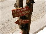 3
3 4
4 5
5 6
6 7
7 8
8 9
9 10
10 11
11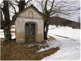 12
12 13
13 14
14 15
15 16
16 17
17 18
18 19
19 20
20 21
21 22
22 23
23 24
24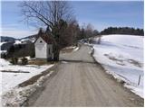 25
25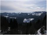 26
26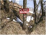 27
27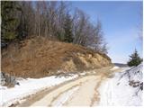 28
28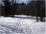 29
29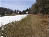 30
30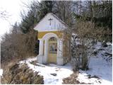 31
31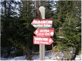 32
32 33
33 34
34 35
35 36
36 37
37 38
38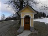 39
39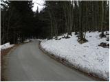 40
40 41
41 42
42 43
43 44
44 45
45 46
46 47
47 48
48 49
49 50
50 51
51 52
52 53
53 54
54 55
55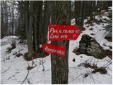 56
56 57
57 58
58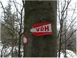 59
59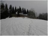 60
60 61
61
Discussion about the trail Ernejčkov graben - Pasja ravan