Ipsos, Pirgi - Pantokrator (via Spartylas and Strinilas - from south side)
Starting point: Ipsos, Pirgi (1 m)
Name of path: via Spartylas and Strinilas - from south side
Time of walking: 2 h 30 min
Difficulty: easy marked way
Altitude difference: 911 m
Altitude difference po putu: 912 m
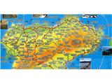
Map: Krf
Recommended equipment (summer):
Recommended equipment (winter):
Views: 1.170
 | 7 people like this post |
Access to the starting point:
Corfu is the largest Greek island in the Ionian Sea, measuring about 65 km long north-south and much narrower wide. In area, it is larger than the better-known Croatian island of Krk. Corfu is very mountainous, extremely green and relatively watery inland. Apart from the main and very busy coastal road Corfu - Lefkimi, the other roads inland are much less busy, mostly asphalted or paved, but also quite narrow. From Corfu, the largest or capital city, which is in the central part of the island, head north, and in Gouvia take the coastal road towards Dassia and Ipsos, where you can find a suitable parking area in the hinterland. The following is a description of the route to the summit by bicycle, so the walking time has been replaced by the cycling time.
Path description:
Cycling - and other more strenuous walking trips in the middle of summer - should be chosen wisely, either early in the morning or in shaded areas, as the heat is really intense here and any major exertion in the middle of the day is really not recommended. It's much easier to rent a scooter, quad bike or car on Corfu than a bike, so - if you're a bike addict, you should come to the island and take your own bike. Greeks are also not used to cyclists in traffic, so take care - if you're on a bike you need to look out for both yourself and the locals in cars, who don't seem to have much regard for a cyclist's weakness compared to motorised vehicles. There are several routes to the highest peak of Pantokrator, for example from the north coast from Acharavi, but we started from the south side from Ipsos or Pirgi. We leave the main coastal road through Pirgi after a good km and turn left for Spartylas (and signs for Episkepsi). To Spartylas there are about 5 km of nice serpentine roads between old olive groves, then the road becomes flatter and we drive another km to a pass and a crossroads where the road turns right for Pantokrator (well marked, with signs for Strinilas next to it). The road continues for about 12 km, up a nice and not too steep incline, in the early morning the hill is still in shade, then the road takes us through the village of Strinilas, and before the village of Petalia there is another turn off to the right, all marked and easy to follow. The last kilometre below the summit, after a short flat stretch, the road becomes a little straighter and narrower, and the asphalt surface is replaced by concrete. At the top there is a cluster of tele-communication antennas, a former Orthodox monastery with a church and a buffet, and truly wonderful views far and wide. Descending back to the ridge, we took the option at the pass of passing through the villages of Sgourades and Zygos, mostly downhill, and a short climb to Sokraki, from where it is a real pleasure to descend down through Agios Markos and towards the coastal starting point on a new very serpentine and scenic road (also built with EU funds). The route described is about 20 km to the top, and about 10 km more on the way back with the circular extension described above. I unintentionally made a comparison with Biokovo, to Sv. Jure from Makarska, but this is at least one step harder than the one described to the Pantokrator in Corfu.

Pictures:
 1
1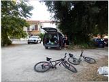 2
2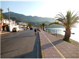 3
3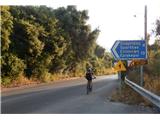 4
4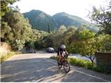 5
5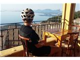 6
6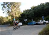 7
7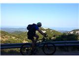 8
8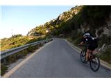 9
9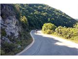 10
10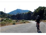 11
11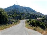 12
12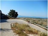 13
13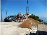 14
14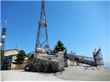 15
15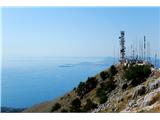 16
16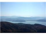 17
17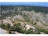 18
18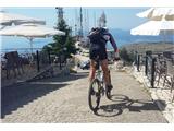 19
19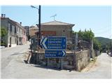 20
20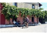 21
21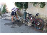 22
22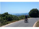 23
23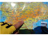 24
24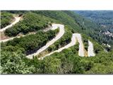 25
25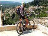 26
26 27
27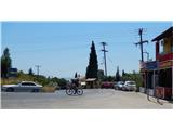 28
28 29
29
Discussion about the trail Ipsos, Pirgi - Pantokrator (via Spartylas and Strinilas - from south side)
|
| SamoK10. 08. 2016 |
Spet en dolgočasen potopis, ki se šverca kot izlet.
|
|
|
|
| gams110. 08. 2016 |
meni pa so ti opisi izletov všeč, avtorju - kar objavi še kaj takih, morda pa še kje bližje naši deželici. V Grčijo pač ne gre vsak.
|
|
|
|
| fpetel111. 08. 2016 |
Popravek!
Ne gre za zahtevno označeno pot, če je vozna cesta do vrha hriba.
Lp.
|
|
|