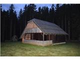
Murijeva planina below Mlinarjevo sedlo - Na Križu (Kokrska Kočna) (on NW ridge on Kočna or peak Na Križu)
Starting point: Murijeva planina below Mlinarjevo sedlo (1200 m)
Name of path: on NW ridge on Kočna or peak Na Križu
Time of walking: 8 h
Difficulty: rock climbing ascent
Altitude difference: 1284 m
Altitude difference po putu: 1500 m
Map: Kamniške in Savinjske alpe, Grintovci
Recommended equipment (summer): helmet
Recommended equipment (winter):
Views: 7.170
 | 4 people like this post |
Access to the starting point:
At Zgornji Jezersko, turn right off the main road into the Makekova Kočna valley. Follow the macadam road and at the parking lot next to the old ski resort continue straight ahead towards the forest. Follow the road up to 1200 m, just before the road flattens out and bypasses Mali vrh. Park in the forest where cart track (below Murijeva mountain pasture) branches off to the left in the route back.
Warning: as the best way down is past Češka hut or Suhadolnik, due to the difficulty, it is necessary to think how to get back to the car; the best way is to use another car, which you have left at one of the above-mentioned places.
Path description:
Follow cart track past Murijeva's mountain pasture under Mlinar's saddle to the hunting hut and from there along the marked trail to Veliki vrh (1700 m), which can be reached in 1 hour and where our ridge begins.
From the Big Peak we immediately stick to the ridge, where for the first hour we follow the marked and sometimes burnt ridge route through a rather large dwarf pines to a saddle with a larch grove. From here onwards, first on the left side of the ridge, then mostly on the right or directly on the ridge, where it is easiest to get through the dwarf pines. After the first steep sections, the ridge stands upright for the first time, and there are quite nice slabs above us, which can be climbed directly or the ridge can be left into a rather broken gully, which resembles an old quarry due to the exceptional rubble and eroded rocks. The easiest way out of the gully is left on the red rubble and back right over it, following the centre of the gully directly back to the ridge. There are a number of ramps - as long as you are surrounded by dwarf pines, most of the passages on the south side are easier, even when crossing the rather airy ridge towers, but once the easiest is on the north side on a shelf about 5 m below the ridge. It can take up to 3h to get here by dwarf pines just for the ridge from the Big Peak.
When you get to the first prominent ridge tower, notice the old chock on the left below it, go past it to the next ridge tower (III), which is not so prominent, but it is quite a hassle to descend from it, descending by rope is best (no chock is needed as the rope can be tightened around the tooth just below the top of the tower). From the notch, start with the first major head in the ridge. It is climbed in a zig-zag, first to the right (at the start follow the indicated passages in the steep grass), then a short shelf to the right and again a wall to the left, but do not follow it to the edge, as there is a rather ugly slab with a fresh break behind it. 10m before the summit, traverse right again (a thickened shelf) to reach the top of this head (I). From here, descend a few metres to the SW side on a clear gully for about 5m to pass under a slab on a nice shelf and climb back up to a ridge, which is immediately followed a few metres later by a retreat right down the grasses. There are steep grasses on the ascent to the next head, and first a 2 m slab in the canyon, which has very nice steps. The easiest way to climb this grassy part is with a crampon, which offers excellent support in the steep grass (especially if the grass or ground is wet). As with the previous head, somewhere around 2/3 of the way up, we traverse right to the edge and follow the edge to the top of the head, where we face the hardest part (the Altarpieces).
Although most descriptions suggest crossing these exposed towers directly, the most beautiful passage is lower down. From the head, return a few metres lower and cross a grassy shelf to a grassy shoulder where a passage opens up under the panels of the Altar Towers. The grassy ridge is not too steep, but we descend it enough to see a beautiful ridge ahead of us, which turns into a ledge (the towers' extremely beautiful but smooth and vertical slabs are above us all the time). Just before the ledge in the wall ends, we are greeted by a wedge in the short wall above the grassy ledge. To the right of it, a distinct crack runs across the slab - especially on its left side there are very nice buttresses, the rock is compact unlike most of the rest of the ridge. At the crack, climb these few metres (III) to a grassy bottom where a gully (left) from the notch between the last Altar Tower and the next shoulder and a beam of light boulders (right) meet. On leaving the crevasse, first go left for a few metres (another steel cable) then cross the grass to the right past a small steel cable into the scree to the right of you (II). At the top of this cairn, an easy passage opens up to the left back to the ridge (thus avoiding all the problems on the Altar's crumbling saw).
Continue a few metres below the ridge, returning to it only after a traverse to the left of a nice sloping slab. When the ridge again becomes too choppy, we go around it on the left, above or through a short gully, which we soon come to again, which serves us with one last problem: a vertical 8 m slab. Two metres above the notch, a sharp shelf goes over the slab to the right, along the edge of which we can find excellent handholds for traversing right to the steep jam (III, maybe IV). Just above the end of the steel cable, there is another old chock on the left edge of the jam, and above it only easier crags await. Follow the ridge to the summit heads, over which you will reach the summit of Na križu (2484 m), which according to old reports was formerly Kokrska Kočna.
From the top follow the ridge to the first notch, then slightly right down below the rib, around it, and then cross the south slopes on light cinders a few metres higher to a distinct saddle with reddish sand and rubble, over which you go to the E side (facing Grintovec) and from which you descend diagonally left down towards the gully, where you find the marked trail to Kokrska Kočna (in reality Na križu) (On the Cross).
Here you decide to continue according to the planned descent, which depends on the mode of transport to the car at the starting point. If this is via Suhadolnik, we descend past the bivouac to Dolce and via Taska. If it is to Jezersko, you have to follow the protected path to the top of Jezerska Koča and then follow one of the protected paths past Česká hut.
The route offers exceptional views, and in the most difficult places the rock is compact enough and extremely rugged. Orientation is not always trivial, especially when climbing in fog, so it's no wonder if you need to backtrack a few metres and take the other side. This is also why there is a wide range in time (depending on how many places you belay), the climb can take anywhere from 7 to 12 hours. Pins and butterflies come in handy for belaying, as they make much faster progress.

Pictures:
 1
1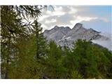 2
2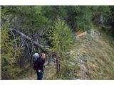 3
3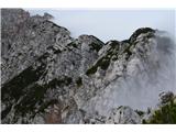 4
4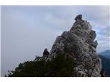 5
5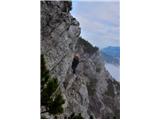 6
6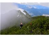 7
7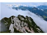 8
8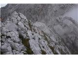 9
9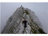 10
10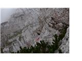 11
11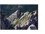 12
12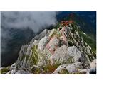 13
13 14
14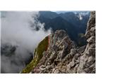 15
15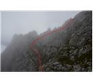 16
16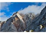 17
17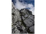 18
18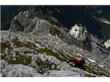 19
19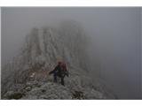 20
20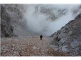 21
21
Discussion about the trail Murijeva planina below Mlinarjevo sedlo - Na Križu (Kokrska Kočna) (on NW ridge on Kočna or peak Na Križu)
|
| dprapr16. 09. 2015 |
Če se prav spomnim, se da tam, kjer je označen spust po vrvi,tudi desno naokoli, brez spusta. Spust ni potreben nikjer.
Ker je to izrazito grebenska smer, se mi zdi škoda zapuščati greben tam, kjer je najbolj "zanimiv". Najbolj delikaten detajl v tem delu (troglavi stolp) ima dobro skalo in se ga da lepo splezati po levi strani navzdol!
Zgoraj, kjer omenjaš morebitno IV, so dobri oprimki, kljub navpični, kratki steni. Moje mnenje je, da je tam še III vprašljiva.
Je pa ta SZ greben po dolžini "plavanja" po borovcih in poplezavanja po skalah res prava zadeva za "grebenarje".
|
|
|
|
| janezs7316. 09. 2015 |
glede spusta se strinjam. tudi sam se med spuscanjem kolega opazil prehod na desni  Oltarskim stolpom sva se izognila, ker sva ocenila, da so obhodi prevec krusljivi... pa se megla je bila tocno takrat tako gosta, da bi jo rezal, tako, da nisem bil povsem preprican, kje je kaj na zadnji steni sem dal oceno na podlagi izkusenj iz plezalnih vrtcov, ker je teza telesa povsem na rokah.. se pa strinjam, da so ravno tam oprimiki fantasticni je pa tudi izpostavljenost ravno pravsnja... kakorkoli, cisti uzitek
|
|
|
|
| dprapr16. 09. 2015 |
Juš, ni nobeno čudo, čuda so v Martuljku!
|
|
|
|
| janezs7316. 09. 2015 |
lahko bi ta greben poimenovali kot "sprejemni izpit" za grebenarje.. do pravih Financarjev je pa še kar daleč...
|
|
|
|
| JusAvgustin16. 09. 2015 |
aja, ja no ne vem omenjate III. mogoče celo IV... Bom šel pogledat, potem pa podam mnenje. Prej ga ne morem, kajne? 
|
|
|
|
| Jovan Cukut16. 09. 2015 |
Ampak po grebenu, Juš, tako kot jaz in ekipa. In le glej, z varovanjem, čeprav bo to zate, kot alpinista z izkušnjami, sprehod.
Srečno. Jovan
|
|
|
|
| ljubitelj gora16. 09. 2015 |
Tisti, ki hočejo lažji greben je JZ, plezanje I stopnje, mogoče kak krajši odsek II. stopnje.
|
|
|
|
| di1. 09. 2020 |
"Normalni pristop. Suhadolnikova pot na Kokrsko Kočno pripelje tik pod greben, ki povezuje Kokrsko Kočno in vrh Na Križu (prehod v Povnovo dolino, 2441 m). Na desno markacije vodijo v zavarovan vršni del Kokrske Kočne, mi pa se obrnemo v levo (JZ), preplezamo nekaj neizrazitih vrhov in se vzpnemo na najvišji vrh: Na Križu. Težave so I. stopnje." (Marijana & Marko); (podobno verjetno tudi LG)
Vprašanje pa je:
Da prideš (v obratni smeri, kot je opisano - torej gledano iz smeri, ko greš čez Grdi graben gor) do melišča na sliki 21, ali torej prečiš nižje in "mimo" Bivaka v Kočni (tako je razumeti podpis pod to sliko)?
(Je pa splošna težava, ker se velikokrat na teh predelih pojavi in zadržuje megla.)
|
|
|