Na Razpotju - Krofička (hunter's way)
Starting point: Na Razpotju (770 m)
| Lat/Lon: | 46,392°N 14,6273°E |
| |
Name of path: hunter's way
Time of walking: 3 h 40 min
Difficulty: difficult pathless terrain
Altitude difference: 1313 m
Altitude difference po putu: 1313 m
Map: Kamniške in Savinjske Alpe 1:50.000
Recommended equipment (summer): helmet
Recommended equipment (winter): helmet, ice axe, crampons
Views: 16.139
 | 2 people like this post |
Access to the starting point:
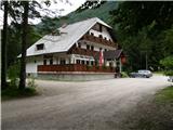
We drive to Luce (to get here from Mozirje or via Kranjski rak) and on to the Logar valley. Shortly after the village Solčava, you will come to a crossroads where the road to the Logarska dolina branches off to the left. Turn left towards the Logar valley (toll) and follow the road to the signs for the hut at Klemenča jama. Park in the parking lot near the Na Razpotju guesthouse. Only guests are allowed to park in front of the guest house.
Path description:
From the parking lot, follow the forest road towards Klemenče jame. After a few minutes' walk, a wide path branches off to the left towards Klemenča Jama. Take this path, which starts to climb. The path, which is quite steep, soon leads to steep slopes, where you cross a slightly exposed ravine with the help of a rope. The path that continues to climb soon leads us to a place where the wall closes the path. Ahead of us we see a cave and above it a marking which directs us into the cave. When we enter the cave, we see that it is not a cave, but a beautifully made tunnel through which we continue. In the tunnel, we have a rope to help us, but we need it more for the descent than for the ascent. On the other side, we cross an exposed ledge on a wide path with a slight incline. The path continues into the forest and climbs steep slopes which are dangerous to slip on when wet. Next, cross another ravine over a small bridge, and then the path leads us to a less steep part of the path, where we join the path from the Planincev home. Continue slightly up the wide path, which soon leads us out of the forest. There is only a short climb up the grassy slope to the hut at Klemenči jama.
From the hut, continue straight in the route Ojstrica along the path, which after a few dozen metres goes into the forest. The path, which climbs moderately to steeply through the forest, leads us higher under rocky cliffs, which are not too crumbly. The path then retreats to the right and leads to a crossroads, where we continue left in the direction of Ojstrica along the Kopinškovi path (right Škarje). Further on, we pass out of the forest onto the slopes covered with dwarf pines and individual larch trees, from which we have a beautiful view towards the northern wall of Ojstrica. Next, pay attention, because soon to the left, from the marked path to Ojstrica, an unmarked hunting trail branches off to Krofičko. When you see cairn (about 10 minutes before the Kopinškova trail crosses to the other side of the ridge), turn left onto a faintly visible path which leads you over a partly rocky and partly grassy slope surrounded by dwarf pines and individual trees to the foot of the north-western cliffs of Krofička. A short, very steep climb follows, which is negotiated by means of a rope, and the path leads to an initially narrow and exposed ridge. Grebenc, which is slightly overgrown with dwarf pines, then quickly widens and, with the help of some fixed safety gear, leads us to probably the most difficult part of the route. With the help of a rope ladder (partially damaged on 12. 6. 2008) we climb the almost vertical and exposed chimney, which is about 10m high. The steepness then suddenly eases and the path leads to sunny meadows (the slope is called Last Meadow), where the path gradually disappears. The ascent continues transversely in a north to north-easterly direction on a gradually steeper and steeper slope. When you reach a fairly steep slope, you stop climbing transversely and continue straight up the very steep slope. If you want to avoid the last steep climb, you can continue a little below the top in a slightly d
Na Razpotju - Klemenča jama 1:10, Klemenča jama - Krofička 2:30.

We can extend the trip to the following destinations: Matkov kot
Pictures:
 1
1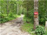 2
2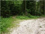 3
3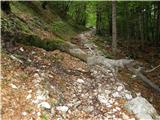 4
4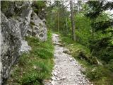 5
5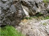 6
6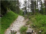 7
7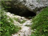 8
8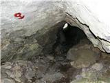 9
9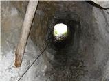 10
10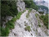 11
11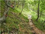 12
12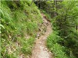 13
13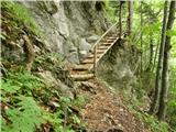 14
14 15
15 16
16 17
17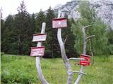 18
18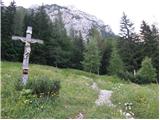 19
19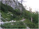 20
20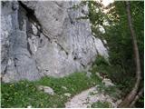 21
21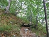 22
22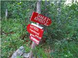 23
23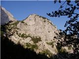 24
24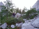 25
25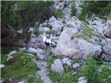 26
26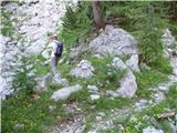 27
27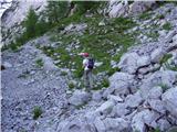 28
28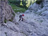 29
29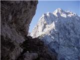 30
30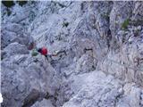 31
31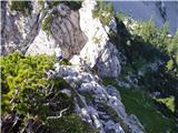 32
32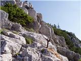 33
33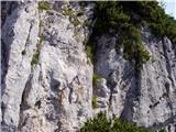 34
34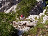 35
35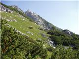 36
36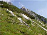 37
37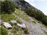 38
38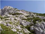 39
39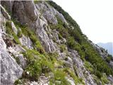 40
40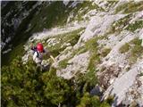 41
41 42
42 43
43
Discussion about the trail Na Razpotju - Krofička (hunter's way)
|
| Jany25. 08. 2008 |
Tudi sam sem poskusil na Krofičko po nemarkirani Lovski poti. Do vzpona na Zadnji travnik je šlo brez težav od tod dalje pa nikakor nisem našel prehoda skozi ruševje na vrh. Po neuspelih poskusih sem se vrnil po isti poti, ki pa je ob sestopu še nevarnejša kot pri vzponu.
Ker vsekakor nameravam v kratkem vso zadevo ponoviti, prosim za pomoč oz. podrobnejši opis drugega dela poti od travnikov do vrha.
Hvala in LP
|
|
|
|
| Tadej25. 08. 2008 |
Če pogledaš sliko, ki je na spodnji povezavi si lahko že od daleč pogledaš najugodnejši prehod med rušjem. Na sliki se vidita dva vrhova (Krofička glavni vrh je desni). http://www.hribi.net/slika.asp?pot=29764
|
|
|
|
| fpetel128. 10. 2008 |
zgleda kr zahtevno tam ko je poškodovana jeklenica. A se lahk samovaruješ na tistem mestu, al vsaj gor potegneš?
|
|
|
|
| Tadej29. 10. 2008 |
Jeklenica še vedno drži, je pa zaradi dveh utrganih klinov precej majava. Malo več previdnosti pa gre. Kar se samovarovanja tiče pa mislim, da ti bo samo v napoto.
|
|
|
|
| garmont3. 07. 2011 |
Danes sem se povzpel po tej poti . Tudi sam nisem našel prehoda skozi rušje, zato sem se odpravil proti vrhu Krofičke skozi škrbino ( na drugi strani je zavarovana pot ). Pot je res izpostavljena , tako, da sem pod škrbino uporabil vrv ( hvala za prusik na vrhu ).Prej omenjena varovala pa so OK.
Lp
|
|
|
|
| krasovc3. 07. 2011 |
Tud sam sem mel probleme. Sicer poteka pot (ce lahko tako recemo) malo bolj na desno od tiste kjer ste sli vi, recimo enih 300 mt bolj naprej. To sem opazil ko sem, prej, sestopil prav kjer ste sli vi gor, pa sam sem bil in ni blo kar tako.
Za naslednje racunate da zadnji del gre kot ravna crta proti vrhu (ni lahko a se da, malo je za poplezat)
|
|
|
|
| Punklc29. 08. 2011 |
Včeraj sem bil na Krofički, ravno po tej poti. Čez Škrbino je pot še kar izpostavljena, vendar varovana. Jeklenica iz zgornje slike majava, samovarovanje bi bilo po moje res le v napoto. Paziti je potrebno, da predno se obsiš na tole jeklenico, da si jo dobro napneš, ker je na sredini višine ovita okoli zabitega klina. Ko pridete na čistino, se odpre lepa pot čez travnike in ruševje proti vrhu. Ko boste pod vrhom (skoraj do konca travnikov)lahko izberete dve poti. Ena gre direkt pod steno Krofičke. Tam bodo potrebne plezalne veščine, drugo, t.j. v desno, sem ubral sam. Pot čez travnike je že nekoliko načeta (vidna). Potrebno se je držati desne smeri in pred prvim ruševjem se najde možic. Kar je mene motilo je to, da sem se moral kljub ruševju ves čas držati desno in iskati nadaljno pot tudi čez ruševje (malo sem zašel). Na koncu te moje poti ter na sliki zgoraj, se dobro vidi vzpon proti vrhu, ki je nekoliko krušljiv. Tik pred vrhom je kratek odcep v levo in že smo zgoraj. Varen korak želim!
|
|
|
|
| b.temlin28. 11. 2011 |
27.11.2011 smo bili po lovski bolj brezpotju na Krofički. Malo težav pred vstopom na pot pod Škrbino, nismo bili sigurni vstopa. Nadaljevanje, po vzponu po visečih jeklenicah smo pa šli diagonalno po pobočju proti sedlu po vrhom Krofičke, nato direktno proti vrhu malo plezarije in nad zadnjimi borovci desno pa na vrh. Snega ni nikjer, je pa bila zaledenela in zasnežena markirana pot ob spustu. Vzpon je zelo zanimiv, ni za vzpon v megli in začetnike, z redkimi možici si nismo nič kaj dosti pomagali, vreme fantastično-kratki rokavi, fotografije na WWW.pdmaticams-drustvo.si.
|
|
|
|
| Avanturistični kozorog21. 06. 2012 |
21.06.2012 - Odcep lepo viden, na poti je možic. (cca.10 min pred Šrbino - 1800 m.n.v.) Čez prvo škrbino lepo nadelana pot s klini in jeklenicami. Višje sta klina še vedno izruvana, vendar ne povzročata težav. Potem diagonalno prečimo travnike, pri steni prvih 50 m.n.v. ob steni, nato v desno do gostega ruševja. Do vrha ruševja plezamo s vsemi štirimi ob ruševju s iskanjem lepih oprimkov in prehodov, a večinoma naravnost navzgor. Vrh je na desno. Srečno
|
|
|