Starting point: Pristava (330 m)
Time of walking: 1 h 15 min
Difficulty: easy marked way
Altitude difference: 468 m
Altitude difference po putu: 468 m
Map: Ljubljana - okolica 1:50.000
Recommended equipment (summer):
Recommended equipment (winter): crampons
Views: 6.990
 | 1 person likes this post |
Access to the starting point:
Pass the Medno Motel, then turn left towards Slavkov's home, after a kilometre turn right towards the village of Žlebe.
After another kilometre, the road splits. You can continue on the left as well as on the right.
The hamlet of Pristava can be reached by either route. Park your car in the hamlet of Pristava above the village of Žlebe.
Path description:
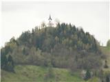
The trail is marked at all times with signs from the tourist board. First you pass the church of St Marjeta, the next sign is the sign, Behind the castle, there are the ruins of a former knight's castle. From there on, the path starts to climb steeper, to a sharp left turn, where a very steep path to Jetrbenk branches off to the left, and along the right path you arrive after a few minutes at a clearing, there is a sign, Gute. Here you can see the view of: the Horn to the west, St. James to the north and, further to the right, Osolnik. You continue along a fairly flat stretch and arrive at a chapel at the crossroads of three paths. The left one leads to the more moderate Jetrbenk, the left one leads from Slavkovy dom, the path to Rog is on the right on macadam, after 500 m you leave the road, turn right, first to Pehar and then to Rog. The view on all sides is breathtaking in clear weather.
Pictures:
 1
1 2
2
Discussion about the trail Pristava - Rog