Rudnik v Topli - Dom na Peci
Starting point: Rudnik v Topli (1080 m)
| Lat/Lon: | 46,4859°N 14,7647°E |
| |
Time of walking: 2 h
Difficulty: easy marked way
Altitude difference: 585 m
Altitude difference po putu: 650 m
Map: Kamniške in Savinjske Alpe 1:50.000
Recommended equipment (summer):
Recommended equipment (winter): ice axe, crampons
Views: 19.198
 | 3 people like this post |
Access to the starting point:
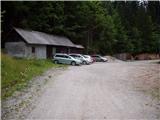
a) Drive to Črna na Koroškem (to get here from Ravenna na Koroškem or from Šoštanj via the Spodnje Sleme pass), then continue to Koprivna. The road continues along the Meži River, and we follow it to a crossroads where the road to the Topla valley branches off to the right. The road continues along the Topla stream, and we follow the ascending road to the parking lot at the entrance to the Topla mine.
b) We drive to Luce (to get here from Mozirje or from Kamnik via the Volovljek (Kranjski Rak) pass), and then continue driving towards the Logar valley. In the village Solčava, leave the main road towards the Logar valley and turn right towards Podolševa, the pass Spodnje Sleme and Črna na Koroškem. The road then loses its asphalt surface, and after a few kilometres we turn right at the crossroads in Podolševa towards Črna na Koroškem. The road, which continues to climb mainly in a transverse direction, leads us after a while to the Spodnje Sleme Pass. From the pass the road starts to descend and we follow it in the direction of Črna na Koroške. After a few kilometres, when we descend into the valley, we turn right at the crossroads towards Črna na Koroškem (Koprivna on the left). We follow the main road down for a short distance, and then the signs for the Tople valley direct us left onto the ascending road. The path ahead leads us along the stream Topla, and we follow the ascending road to the parking lot at the entrance to the mine in Topla.
Path description:
At the end of the parking lot, you will reach a junction of two minor dirt roads, where you take a sharp left in the route Dom na Peci. The road then crosses a clearing above the parking lot and leads us just a little higher to the next crossroads, where we continue to the right (left entrance to the mine - 5 minutes). The way ahead leads us along a road that gradually changes to cart track, which leads us a little further to the next marked crossroads.
Continue along the lower wider cart track (slightly left Knipsovo sedlo), which then crosses a pasture fence and leads to a water trough beyond it. The path then crosses a partly scenic meadow, after which it enters a forest and begins to climb steeply. Higher up, the path leads over a ravine and then begins to climb through a grassy forest. A little higher still, we reach a place where a sign "Newly traced path" directs us to the left up a steep bank (the old path is closed due to an avalanche which prevents safe passage). Climb steeply for a short time, then the path leads to the aforementioned landslide, which is reached higher than the old path. Even on the new route, the crossing is somewhat awkward and dangerous for slipping. On the other side of the avalanche slope, the path starts to climb steeply again and then returns to the old route. The path continues on a moderate ascent, crossing the slopes to the east, and we walk along it to the crossroads at the hunting lodge (the hunting lodge is visible on the right, but it is slightly off the path).
From the crossroads continue in the route Dom na Peci, and after a few minutes the path leads to the next crossroads.
Here we continue directly to Dom na Peci, which is only a few minutes' walk away, or we can continue right to the cave of King Matjaž, which is about a 5-minute walk away. If you continue past the cave, the walk is about 10 minutes longer.

Pictures:
 1
1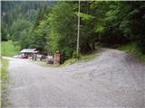 2
2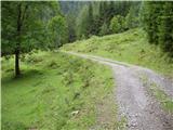 3
3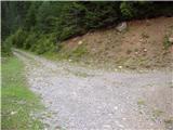 4
4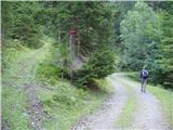 5
5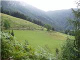 6
6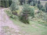 7
7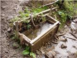 8
8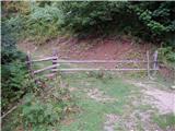 9
9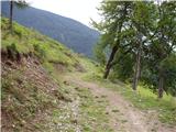 10
10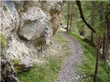 11
11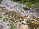 12
12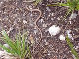 13
13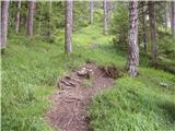 14
14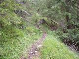 15
15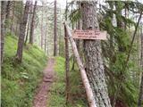 16
16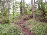 17
17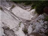 18
18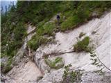 19
19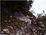 20
20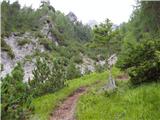 21
21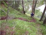 22
22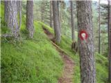 23
23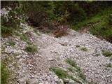 24
24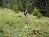 25
25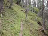 26
26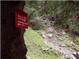 27
27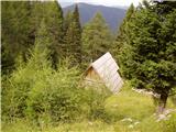 28
28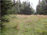 29
29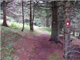 30
30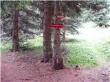 31
31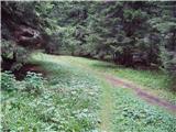 32
32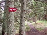 33
33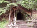 34
34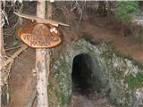 35
35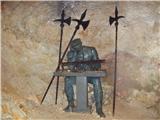 36
36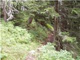 37
37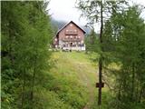 38
38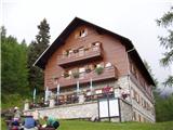 39
39
Discussion about the trail Rudnik v Topli - Dom na Peci
|
| bostjan854. 06. 2010 |
vem da to vprašanje ni ravno na to temo zgoraj,pa vseeno bi vprašal,kako se pride do Božičeve kmetije,v nedeljo grem na Peco,pa če bom že v teh krajih bi še si rad ogledal Rezmanov slap in Božičev slap.
|
|
|
|
| Petr5. 06. 2010 |
če v Črno iz Šoštanja, 2 km pred centrom Črne, 1km pred tablo za Črno, na ovinku (desno hiša) zaviješ levo strmo na makadamsko cesto (oznaka Najevska lipa). iz Črne pa obratno 2 km proti Šoštanju in potem desno za Najevsko lipo. po oznaki kmetija Senčnik desno, sledijo štirje desni oviki. v tretjem je levo Rezmanov, v četrtem pa Božičev slap. 100 m naprej je kmetija Božič. Božičev slap je delno viden že s ceste, Rezmanov pa s ceste ni viden.
|
|
|
|
| bostjan855. 06. 2010 |
Petr,hvala ti,bom poskusil 
|
|
|
|
| Bajtur28. 07. 2011 |
Pozdravljeni! Sem ubral eno družinsko po tej poti. Lepa pot, a žal je bilo vreme bolj kislo. Hvala bogu za pelerino. Tisti nevarni prehod čez grapo je res že bogi. Lesena lojtra iz debel visi samo še na eni točki in bo vsak čas zgrmela v dolino. Priporočam plazenje po vseh štirih tik ob steni. 
|
|
|
|
| megalodon25. 06. 2012 |
Bi šli z družino po tej poti, najmlajši star 4,5 let navajen hoje po planinskih poteh, pa me vseeno zanima kako je zdaj s tem prehodom preko grape(hudournika). Je zrihtano, varno?  Hvala za vsakršno informacijo.
|
|
|
|
| jprim25. 06. 2012 |
Ta pot preko hudournika je že nekaj časa nazaj urejena - nadelana, je pa treba na tem območju pazit na gade.
LP!
|
|
|
|
| megalodon25. 06. 2012 |
 dobra novica (tale o gadih), glede na to, da naši nadebudneži med potjo niso ravno "privezani" na naju z ženo in gredo prav radi tudi sami malo naprej. A lahko kako informacijo več o teh gadih. A so pogosti skozi celotno pot ali samo na tem predelu.  (Sam se jih sicer ne bojim preveč  , čeprav nisem njihov "fan" bolj mi gre zaradi otrok)
|
|
|
|
| jprim25. 06. 2012 |
Srečala sem ga na tem predelu, bil je kar na sami poti, skoraj bi ga pohodila, verjetno še kje drugje, če povem, da sem enega skorah spet pohodila na poti iz Komne proti planini govnjač, umaknil se je zadni čas in potem še ob povratku iz Kuka na mulatjeri, kjer sem slišala samo sikanje - bila sem kar v trenutku v zraku, videl ge je mož, ki je obakrat bil za menoj, komentiral je, 'ta je bil še mladič in pospravljal je miš na poti ... nauk zgodbe, glej pod noge na pot in ne bodi preveč hiter
|
|
|
|
| rifnik2. 06. 2018 |
Pozdravljeni!Zanima me če je v Domu na Peci žig tudi od vrha Pece,Kordeževe glave.Hvala
|
|
|