Starting point: Rudno polje (1347 m)
| Lat/Lon: | 46,3458°N 13,9236°E |
| |
Time of walking: 4 h 10 min
Difficulty: difficult pathless terrain
Altitude difference: 751 m
Altitude difference po putu: 1000 m
Map: Triglav 1:25.000
Recommended equipment (summer): helmet
Recommended equipment (winter): helmet, ice axe, crampons
Views: 15.030
 | 2 people like this post |
Access to the starting point:
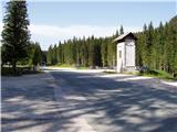
From the motorway Ljubljana - Jesenice take the exit Lesce and follow the road towards Bled. At the traffic lights in Bled, the signs for Pokljuka direct you to the right. Continue through Gorje and past the abandoned ski resort Zatrnik to Rudni Polje on Pokljuka (a large parking lot, a military barracks and a shooting range).
Path description:
At the end of the parking lot, a macadam road branches off to the right with signposts for Triglav. Take this road, which climbs gently and after 10 minutes leads to the ski resort. Continue along the road, from which the marked path to Triglav soon branches off to the left. After a few minutes of moderate ascent, the path leads us to a forest road, which we follow for only a few metres (we can get here by car, which shortens the journey by 20 minutes). The marked path then veers right and climbs steeply for a short time. After ten minutes, the steepness subsides and the path slowly switches to steep slopes. After these steep slopes, the trail descends gently for the most part and turns increasingly to the right. A little further on, we will see mountain pasture Konjščico below us on the left. Our path then stops descending and passes out of the forest between dwarf pines. The path that climbs again then leads us under steep rocky cliffs and soon afterwards leads us to a crossroads where we join the path with mountain pasture Konjščica. There is a short climb and the path leads us to a beautiful valley called Jezerce. Here the path turns left and after a few steps leads us into the narrower area of the TNP. Next, we climb along the small spring towards Studorski Preval. A little higher, cross the torrent and the path turns slightly right into the grassy slopes surrounded by dwarf pines. The path then ascends crosswise to Studorski preval, from which a fine view of the Bohinj side opens up. The way forward initially descends slightly, then crosses the slopes of Veliki Draški vrh and Tosc with some slight ascents and descents. After a while the path leads us to the grassy southern slope of Tosc. Here, the path to Tosc branches off to the right, and just a few metres further on, the path from Uskovnica joins us from the left. Continue straight ahead, still crossing the slopes of Tosc. The path then crosses a short lane of sparse forest in a slight descent and then leads us to steep slopes. A little further on, the path crosses the precipitous slopes of Tosc on an artificially made wide ledge in a gentle descent. As the path is quite wide it does not cause any problems (caution due to falling rocks, rock fall in 2008). The path then climbs slightly again and leads us to a crossroads where we continue to the right in the direction of Vodnikov's home. There is a further walk of about ten minutes without any major ascents or descents to the Vodnik's home. From home, continue straight on in the direction Triglav (right up Bohinjska vratca). The path climbs moderately and crosses the slopes below Vernar. Soon we come across the first small steel cable, which helps us to overcome a short ledge. The way forward climbs on scree and then leads us to a steep rock jump. A well-protected path leads us up steep steps to the top of this jump. There are a few metres of scrambling up the steep slope, and then the path leads to the open areas near the Konjski Preval. This is reached after a short descent. At Konjsko sedlo , identified by a fork in the trail, leave the marked trail to Triglav. Turn right onto a poorly visible path which leads to a meadow where the path finally disappears. Continue south along the meadow. When dwarf pines ends on the left hand side, follow the ridge to the right to the top of the rocky slope of the mountain. There is some easy climbing on the broken rocks of the summit. The last metres are slightly exposed.
Orientation in the last part is difficult, and very difficult in the fog. The crossing is about 15 minutes.
Rudno polje - Vodnikov dom 3:20, Vodnikov dom - Cesar 50 minutes.

Pictures:
 1
1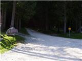 2
2 3
3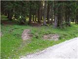 4
4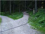 5
5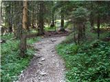 6
6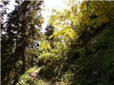 7
7 8
8 9
9 10
10 11
11 12
12 13
13 14
14 15
15 16
16 17
17 18
18 19
19 20
20 21
21 22
22 23
23 24
24 25
25 26
26 27
27 28
28 29
29 30
30 31
31 32
32 33
33 34
34 35
35 36
36 37
37 38
38 39
39 40
40 41
41 42
42 43
43 44
44 45
45 46
46 47
47 48
48 49
49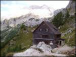 50
50 51
51 52
52 53
53 54
54 55
55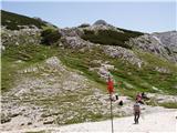 56
56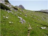 57
57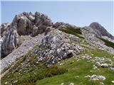 58
58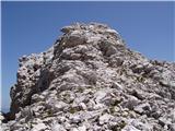 59
59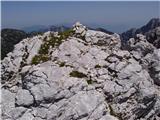 60
60
Discussion about the trail Rudno polje - Cesar
|
| ločanka18. 07. 2014 |
Nisem povsem prepričana, da je ta vrh Cesar. Če berem članek od Janeza Pikona z zgornjim naslovom, je Cesar hrib, ki stoji temu nasproti. Je po obliki precej bolj cesarski in s še lepšim razgledom. Vidi se kot markanten hrib z Malega polja in nam stoji ob desni strani celo pot do Konjkega sedla. Kdo ve pravilni odgovor?
|
|
|
|
| kolosej21. 08. 2018 |
Opis in slike so prave. Zmeda je nastala, ker sta koti za Oklo (2092m) in Cesarja (2098m) na zemljevidu Triglav 1:25000, kjer v prošnji za boljše podatke ne izključujejo možnost napak, zamenjani.
Prosim za pojasnilo ali je potrebno tik pod vrhom Kurice stopiti na veliko skalo v razpoki?
|
|
|
|
| damijanp8. 10. 2018 |
Petkov čudovit dan sva z ženo izkoristila za obisk vrhov v okolici Cesarja. Strinjam se z @ločanka, da je, glede na vse opise, ki jih je mogoče najti, Cesar vrh, ki je nasproti opisanega vrha. Pravzaprav pa je tako vseeno, lepi so vsi. Prav zaradi zmede z imeni, sva z ženo ob povratku obiskala še Veliki Draški vrh, da sva bila lahko vsaj za en obiskan vrh prepričana, kako mu je ime   Nekaj slik je na: Vrhovi v okolici Cesarja - Veliki Draški vrh
|
|
|
|
| Majdag8. 10. 2018 |
lijaneja
17.9.2018 - Cesar je na desni in zakriva Vodnikov dom.... Je napisal lijaneja, torej isti o katerem piše ločanka.
|
|
|
|
| damijanp8. 10. 2018 |
@Majdag: Hvala. Tako se zdi tudi meni, oziroma tako je največkrat navedeno na spletu.
|
|
|
|
| Darxta4. 10. 2023 13:14:03 |
Na izhodišču je malce napačno napisano, da je do Studorskega prevala 1h 30min. In na Studorskem prevalu, da je do Vodnikovega doma spet 1h 30min.
Boljše vodilo je Rudno polje - Studorski preval 2h, Studorski preval - Vodnikov dom 1h 20min.
|
|
|