Suhadolnik - Jezerska Kočna (via Kokrsko sedlo and Dolci)
Starting point: Suhadolnik (901 m)
| Lat/Lon: | 46,3352°N 14,5102°E |
| |
Name of path: via Kokrsko sedlo and Dolci
Time of walking: 6 h 15 min
Difficulty: very difficult marked way
Altitude difference: 1639 m
Altitude difference po putu: 1750 m
Map: Kamniške in Savinjske Alpe 1:50.000
Recommended equipment (summer): helmet
Recommended equipment (winter): helmet, ice axe, crampons
Views: 20.342
 | 3 people like this post |
Access to the starting point:
From the motorway Ljubljana - Jesenice take the exit Kranj - East and follow the road towards Jezersko, but only as far as the village of Kokra. In this village, just a few metres before the road crosses the bridge over the Kokra River, you will see a road leading towards Suhadolnik. The road turnoff is located when we are on the right side of the river (left bank) and the road marker is approximately 7 km. Follow this road to the parking area, which is about 300 m in front of the Suhadolnik farm.
Path description:
At the beginning of the parking lot, you will see mountain direction signs directing you to the road, which will take you to a small crossroads near the Suhadole farm in less than 5 minutes' walk. Here we continue on the road to the right, and we follow it for about 5 minutes, or until we reach the place where the signs lead us to the ascending cart track. We then climb cart track for a short distance, and then the signs direct us to the right onto a footpath which climbs moderately through the forest. Higher up, we return to cart track, which leads us a few metres further to a forest road, which we then follow to its end (it takes about half an hour to get here).
At the end of the road, the marked path splits into two parts. Continue along the left-hand path (to the right, the slightly easier "Old Path"), which climbs further along the folded cart track. A little further on, the markings direct us slightly to the right onto torrential layers of sand, and the path continues through the forest on the other side, where it starts to climb steeply. Higher up, we reach a small cave, and the path beyond it becomes technically difficult. With the help of a rope ladder, we climb a step higher, and the path then continues on a steep slope, where occasionally a wedge helps us. Higher up, the path turns to the right, climbs steep and, especially in the wet, slippery slopes and then leads to an excellently protected crossing. With the help of wooden steps or ladders and the aid of a rope ladder, we climb up the steep slope, which would be very dangerous without the aforementioned fixed safety gear. Higher up, we are helped by a few more pegs, and the route then lays down and crosses a short exposed slope, where we are helped by an emergency fence. Just a little further on, we come to the next ladder, which does not have a belay, but the crossing is not particularly difficult. There is a short descent into a small gully, which is crossed after this. On the other side of the gully we climb steeply (a few staples help us), and then the path slowly lays down and in a few 10 steps of further walking leads us to a place where it joins the slightly easier "Old Path".
There is a short cross-climb and the path leads us to a larger plain where the "old hut" once stood. Cross the tall grasses to the other side of the plain and arrive at a marked crossroads.
Continue straight ahead (left Kočna over Grdi graben) along a moderately steep path, which continues to climb through lane of bushes. Higher up, the path completely lays down for a while, then leads us between dwarf pines, where it starts to climb more steeply. Follow this slightly steeper path, which offers increasingly beautiful views, all the way to the Cojzova koča on Kokrsko sedlo.
From the saddle, continue left in the direction of Grintovec, Kočna and Skute. The path climbs steeply immediately above the saddle and leads us slightly higher to a crossroads where the path to the bivouac under Grintovec and Skuta branches off to the right. Continue straight on the 'main' path, which lays down and turns slightly to the left, where it crosses the slopes of an undistinguished valley called Jama. The path then ascends in a switchback to the top slope of Grintovec - Strehe (this part is very dangerous for slipping in winter), where you reach the next crossroads. Continue left towards Kočna, while the path to the right leads to the top of Grintovec. The path then crosses steep grassy slopes to the west and then begins to descend. Later, the path turns right and continues to descend gently, crossing slightly exposed slopes until it reaches the gentle grassy slopes (Srednji Dolci). Here it joins the path leading over Grdi graben, and a few metres later we are at the crossroads again. Bear right and the path to the left leads to the bivouac below Kočna and Kokrska Kočna. We climb over a grassy slope, which then leads us to a scree slope, which we climb for some time. At the end, the path turns slightly to the left along the scree and leads us into the rocks. There is a short climb slightly to the right to Dolška škrbina (2317m - the lowest point between Kočna and Grintovec). There is also a crossroads on the notch, where we turn left towards Kočna (right Grintovec. The path then leads us along the north side of the ridge and soon leads us to the crossroads again. This time we turn left (straight down Češka koča, right Grintovec) and continue our ascent along the trail, which quickly leads us to one of the most interesting passages in the Slovenian mountains. The trail leads us to a belly-shaped passage through which we have to crawl. The path goes on to a short scree slope, after which we step onto a steeper path, where we are helped by a few wedges and rocks. This increasingly scenic route is then followed to a little spacious summit.
Suhadole - Kokrsko sedlo 2:30, Kokrsko sedlo - Jezerska Kočna 3:45.

We can extend the trip to the following destinations: Kokrska Kočna
Pictures:
 1
1 2
2 3
3 4
4 5
5 6
6 7
7 8
8 9
9 10
10 11
11 12
12 13
13 14
14 15
15 16
16 17
17 18
18 19
19 20
20 21
21 22
22 23
23 24
24 25
25 26
26 27
27 28
28 29
29 30
30 31
31 32
32 33
33 34
34 35
35 36
36 37
37 38
38 39
39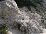 40
40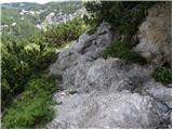 41
41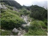 42
42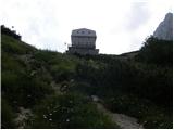 43
43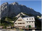 44
44 45
45 46
46 47
47 48
48 49
49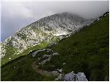 50
50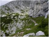 51
51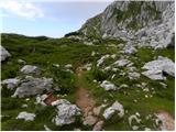 52
52 53
53 54
54 55
55 56
56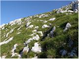 57
57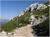 58
58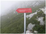 59
59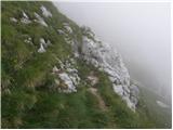 60
60 61
61 62
62 63
63 64
64 65
65 66
66 67
67 68
68 69
69 70
70 71
71 72
72 73
73 74
74 75
75 76
76 77
77 78
78 79
79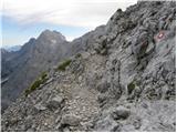 80
80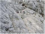 81
81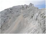 82
82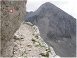 83
83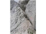 84
84 85
85 86
86 87
87 88
88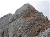 89
89 90
90
Discussion about the trail Suhadolnik - Jezerska Kočna (via Kokrsko sedlo and Dolci)
|
| Hribec14. 08. 2009 |
mogoče je res tehnično najlažja, a če le nimaš strahu pred zajlami je definitivno najkrajša in najlepša varianta od Češke koče.
|
|
|
|
| MBrando20. 10. 2009 |
Bi sel kdo jutri to turo?
|
|
|
|
| CarpeDiem2479. 10. 2014 |
Ta je verjetno res "najlažja", ampak je pa res precej bolj zanimiva KREMŽARJEVA z Jezerskega. 
|
|
|
|
| UplaSporty19. 08. 2023 02:52:23 |
Bomo videli, če še kdaj grem po tej turi. Posebej tisto melišče ni od muh in kaj tam biva. Vam sporočim če iz Ravenske kočne je pa možno priti, iz te ni. TSG. Ponovno pot ni za otroke ker, lahko umrejo.  
|
|
|