The Krma Valley - Dom Planika
Starting point: The Krma Valley (944 m)
| Lat/Lon: | 46,3851°N 13,9071°E |
| |
Time of walking: 4 h 30 min
Difficulty: easy marked way
Altitude difference: 1457 m
Altitude difference po putu: 1471 m
Map: Triglav 1:25.000
Recommended equipment (summer):
Recommended equipment (winter): ice axe, crampons
Views: 52.918
 | 2 people like this post |
Access to the starting point:
Leave the Gorenjska motorway at the Hrušica exit and follow the road towards Kranjska Gora. Just before the village of Dovje, the road branches off to the left and leads to Mojstrana (Vrata, Kot and Krma). Follow the road in the direction of the village of Radovna and the valleys of Krma and Kot. The relatively steep road then takes us past the TNP signboard, after which the road soon lays down and leads us to a crossroads where the macadam road to the valley of Kot branches off to the right. Continue straight ahead on the road, which begins to descend. In the middle of the descent, the road to the Krma valley branches off to the right (straight ahead Radovna). A little further on, you come to the next crossroads, where you continue to the right in the direction of Krma. The macadam road then leads to Kovinarska hut, and we follow it further. Occasionally, a slightly worse road then leads us to the parking lot in front of the gate.
Path description:
From the parking lot, continue past the ramp and follow the winding forest road, closed to public traffic. The minor road continues for a while over extensive gravel, then turns slightly right, where it enters the forest and turns into a rocky cart track. The path climbs gently through the forest for some time, and then, after crossing a slightly larger torrent, it begins to climb steeply through the dense forest. Higher up, the path leaves the forest into lane of dwarf pines, mixed with scrub, and climbs over the above-mentioned slope on rubble. At an altitude of about 1400 m the path lies down and after a further 10 steps leads to a beautiful grassy plain called Vrtača.
On the other side of the plain, the wide path starts to climb again and after about 20 minutes of further walking leads us to Malo polje, where it turns to the right and leads us to a less conspicuous crossroads. Continue on the well-traced path (left Vodnikov dom via Bohinjska vratca), which climbs gently for a while and then leads to a water trough. Next, the path splits into two parts, and we continue straight on the marked path, which leads us over initially grassy, then slightly vegetated slopes to the shepherd's hut at mountain pasture Zgornja Krma.
From the shepherd's hut, continue slightly to the right, along a marked mountain path, which leads us in a few minutes of gentle ascent to a marked crossroads. Continue left in the direction of Planike over Kurica (right Kredarica and Staničev dom) along the path, which starts to climb steeper and steeper. After a few minutes' walk from the crossroads, the path leads to a short rock jump, where it climbs even more steeply. After a few minutes, the steepness eases and the path passes to the gentle slopes north of the less visible Cesar (peak near Kurica). The path continues to turn slowly slightly to the left, where it gradually passes to slightly steeper slopes, over which we climb in a slight cross-climb up to Konjski sedlo (Horse saddle).
From the saddle, continue towards Planika (Vodnikov dom on the left, Kredarica and Staničev dom on the right) along a relatively steep path which climbs steeply westwards. Higher up, the increasingly scenic route leads to an undistinguished ridge, where it turns to the right and transiently lays down a little. The marked path then passes a larger sinkhole on the right and then starts to turn to the left. After about 10 minutes of ascent, the path leads to the Planika lodge under Triglav. Krma - Zgornja Krma 2:30, Zgornja Krma - Konjsko sedlo 1:00, Konjsko sedlo - Planika 1:00.

Pictures:
 1
1 2
2 3
3 4
4 5
5 6
6 7
7 8
8 9
9 10
10 11
11 12
12 13
13 14
14 15
15 16
16 17
17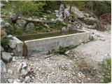 18
18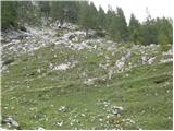 19
19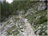 20
20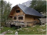 21
21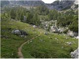 22
22 23
23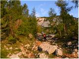 24
24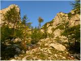 25
25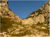 26
26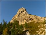 27
27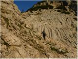 28
28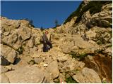 29
29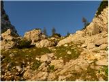 30
30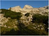 31
31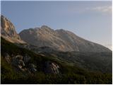 32
32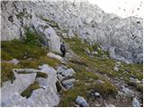 33
33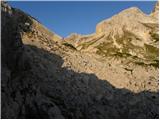 34
34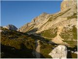 35
35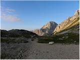 36
36 37
37 38
38 39
39 40
40 41
41 42
42 43
43 44
44 45
45 46
46 47
47 48
48 49
49
Discussion about the trail The Krma Valley - Dom Planika
|
| heinz24. 10. 2008 |
Zanima me ,ali na tej poti razmere v tem trenutku že zahtevajo zimsko opremo- dereze. Koliko je snega in ledu?
Jutri 25.10. se nameravam odpraviti do Planike.
Hvala za odgovore!
|
|
|
|
| Tadej24. 10. 2008 |
Trenutno je pot kopna, tako da zimske opreme ne rabiš.
|
|
|
|
| heinz26. 10. 2008 |
Tadej, hvala za informacijo!
Res je bilo popolnoma kopno, in celo kot je bilo videti, bi enako šlo vse do vrha. Zanimivo je ,kako hitro pobere sneg.
|
|
|
|
| kungočan9. 06. 2011 |
Zanima me od kdaj je odprta Planika, zaradi
rezervacij?
|
|
|
|
| m35759. 06. 2011 |
8.6. sem klical na PD, kjer so mi rekli, da računajo da bodo nekje okoli 20.6. verjetno pričeli z obratovanjem, morda pa tudi kaj prej. Zaradi slabega vremena v teh dneh namreč še niso napotili osebja v kočo. Spodaj so tel. številke.
lp,
matej
Oskrbnica: Irena Klinar 051/614-773
PD: 04/ 57 44 069
|
|
|
|
| kungočan12. 06. 2011 |
Hvala Matej za informacije pa tudi za tel.
številke.Bom poklical ko se bo vreme malo
ustalilo.Lp,
Jure
|
|
|
|
| Pohodnica5617. 07. 2011 |
S sopohodnico bi radi naredili pardnevno turo, iz Planine Blato do Prehodavcev, potem do Tržaske koče na Doliču in naprej do doma Planike in morebiti še do Kredarice.Odvisno od vremena in utrujenosti.
Prosim za malce pomoči, je pot iz Doliča do Doma Planika čez Šmarjetno glavo zelo zahtevna/klini, zajle/. Na hribih sem prebrala, da je delno zahtevna, vendar po slikah sodeč ne morem presoditi, ne bi pa radi nekje na sredini obrnili, ker bi se nama kolena tresla od strahu ali se nama zgodilo kaj nepredvidenega. Kondicijo imava, kar veliko pohodov in malo izkušenj s klini in zajlami.Vsak odgovor bo dobrodošel in z veseljem bova upoštevali nasvete izkušenejših.
Vsem prijateljem hribov lep pozdrav.
|
|
|
|
| pepita25. 07. 2011 |
Pohodnica56,
sama se odpravljam na Triglavska jezera iz soške smeri, in sicer iz Vrsnika (Vas na skali) preko Velikih vrat do koče na Triglavskih in naprej do Prehodavcev in Doliča. Potem pa bomo videli. Odvisno od utrujenosti, volje, vremena.
Saj je veliko poti, po katerih te ni treba biti strah. Pomembno je, da v hribih uživaš.
Lep pozdrav.
|
|
|
|
| mojcej'7225. 07. 2011 |
Karkokoli že kdo roma po gorah, naj prej vedno preveri možnost prenočevanja, čeravno mu začrtani plan ne bi uspel. V poletnem času so koče precej zasedene. Sicer naj ne bi odslovili pohodnika od prenočevanja v koči, zato v skrajnih primerih angažirajo tudi zasilne variante na klopeh v skupnem prostoru, ampak pohodniki lahko veliko storijo že sami, če si pot dobro zorganizirajo prej glede na kondicijo in vreme ter rezervacijo nočitve.
|
|
|
|
| polo1125. 12. 2017 |
v poletnih mesecih nameravam peljati ženo čim bliže Triglavu. Zanima me, če je po tej poti kaj klinov ali jeklenih vrvi, ker se boji višine.
|
|
|
|
| Daaam25. 12. 2017 |
Ni klinov ali jeklenic.. lahko jo pa pelješ tudi na Kredarico..isto nezahtevna pot iz Krme. Bo še bližje Triglavu 
|
|
|
|
| turbo26. 12. 2017 |
@polo11 Če želita čim bližje in ne na vrh, razmisli tudi o poti iz Zadnjice na Dolič in od tam pod očaka. Čudovita pot, razgledna, kar se gneče tiče pa jo je tod manj, kot na Gorenjski strani 
|
|
|
|
| Grenaleva17. 07. 2018 |
Je kdo hodil te dni? Kako je s snežiščem na Kurici? Bolj me zanima za dol. Hvala
|
|
|