Belopeška jezera - Strug (Via della Vita - Vevnica - Strug)
Starting point: Belopeška jezera (929 m)
| Lat/Lon: | 46,4733°N 13,6713°E |
| |
Name of path: Via della Vita - Vevnica - Strug
Time of walking: 9 h
Difficulty: extremely difficult marked way
Altitude difference: 1336 m
Altitude difference po putu: 1600 m
Map: Tabacco 019
Recommended equipment (summer): helmet, self belay set
Recommended equipment (winter):
Views: 23.771
 | 8 people like this post |
Access to the starting point:
From Ljubljana take the Gorenjska motorway to the Hrušica exit. From there, follow the regional road to the Rateče border crossing and continue for a few kilometres to Fužine (Fusine). Here, pass the former chain factory and continue over a bridge. Just after it, there is a marked road turning off (sharp left) towards the Belopeška Lakes. Follow this road to the upper lake, where there is a large parking lot. It takes about 1 hour to get here from Ljubljana.
Path description:
Access to the ferrata :
We will follow the route mountain pasture of the Alpe Vecchia, or the shortest approach to the Via de la Vita. We will follow it up towards Vevnica.
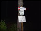
The trailhead and signs can be found at a small inn at the edge of the parking lot. You will soon reach a crossroads, where you continue along the right-hand road marked 513. This leads to the mountain pasture Tamar and continues along its left-hand edge. Shortly after mountain pasture is the next crossroads. Go left here. The waymark is still 513. As you start to climb uphill, watch out for a fork where the dirt track turns into a forest track. If you walk in the dark, this may be a little less visible. The turn-off is marked on a cut spruce tree trunk just off the road (see pictures). Follow the forest path as it climbs steadily up towards the mountain pasture of Alpe Vecchia and, as you leave the forest, you will come to the turn-off for the Via de la Vita ferrata (Via de la Vita ferrata). To get here you can easily walk in the dark (with adequate lighting, of course).
The fork is now well marked and the path to the Via de la Vita ferrata is also well trodden. It starts across a meadow and is clearly visible. The problem comes when the path turns onto rough terrain and traceability is lost. The path runs along the right-hand edge, where red dots can be seen from time to time. Continue towards the large boulder to the right of the rock rib. You MUST NOT turn onto this rib, although there is also a path leading towards it. We continue nicely past the boulder and above it we will catch the marked path again, which turns left above the aforementioned rib. From here on there are no more problems with traceability to the entrance to the ferrata. Problems can be caused by crossing the snowfield shortly before entering, which usually persists all year round.
Ferata Via de la Vita :
The entrance to the ferrata is a short distance before the start of the scree slope, on the left-hand side. It is marked with a red dot. In early summer, it can be blocked by the edge of the snowfield, which makes normal entry impossible.
The start of the route is a story in itself. If you get cold already here, you have no higher ground to look for. The safety belay is just for decoration and is useless. The easiest way to negotiate this rock jump is to free climb the right-hand edge. For the less experienced, belaying with a rope will be very welcome here. Higher up, fixed safety gear is good. The route continues on a ledge system and crosses several rock steps. Climb up towards the central face of the rock massif. The atmosphere is unique and the views are magnificent. We are approaching the most interesting part of the route, unfortunately also the most exposed to the falling rocks that our predecessors usually get. This part starts with a smooth slab of cobbles, on which we can see chains and iron steps from a distance. Here across will be necessary. We grab a chain, find a good place to push off, study the holds and hop . . . . we're over. Careful with the chain. It's not always the best fit, and we can usually only see that when we're over.
The sequel is even more interesting. Following a system of chains and crampons, we ascend almost vertically for a long time to a distinct steel cable where we turn right. Here is the place for the most attractive photos. There is little respite. The climbs and traverses continue until the wall breaks and we reach the scree. The hardest part is behind us. Follow the path and the red dots to the rocky slope in the central part of the gully. On the left is a faded Via de la Vita sign. We have to pass it and start crossing the unguarded rock slope towards the easiest steps. There are plenty of footholds and the slope is not too exposed, so we can progress quickly. Follow the red dots, or ascend towards the top left hand edge. There we see a metal ladder, which is not a problem as it is fully fixed both below and above. Above it, this part of the Via de la Vite ends. Continue to a fork in the path, where the right fork leads to the bivouac and the left fork leads to Vevnica.
Vevnica :
The path to Vevnica is not technically difficult, but it is less visible. In the fog it is practically unrecognisable. The red dots are more sporadic, so it is necessary to see the continuation from a distance. The Fixed safety gear are rare and mostly in good condition. In the initial part of the route it passes over rock steps, but higher up it becomes a ridge traverse over cobbly terrain. Once you reach the saddle, the summit is only a few minutes away.
Strug :
From Vevnica continue in the direction of Ponce. The start is easy. The Vevniška ridge is easily passable and you will quickly reach the end of the ridge. Here you will descend into the Vevniško notch. For a long time, this was the most difficult part of crossing the ridge towards Strug and onwards towards Ponce, as the fixed safety gear completely failed. They were rebuilt a few years ago and are currently in a satisfactory condition. They are damaged in some places (see comments on the pictures), but there are no major problems. This is also the only part of the route that is well protected, as there is no more further on. There are remnants of the old fixed safety gear, but these are extremely unreliable, so use with caution.
After descending into the notch, the ridge traverse begins with places that occasionally require climbing grade 2. We are guided by red dots. Sometimes they are more visible, sometimes less so. If we run out of them, we have gone astray, so it is necessary to go back and look for a continuation. The route always retreats to the Italian side in the problematic parts and can be on very exposed slopes. There is a constant change of ascents, descents, ridges, slopes. The crossing is adrenaline-fuelled and very interesting. When you meet a stone with the inscription Strug along the way, you are practically at the finish line. In a few 10 m you will reach the most isolated mountain of the ridge.
Descent :
There is no classic descent. Strug is usually reached by crossing the ridge from Vevnica to Ponce or in the opposite direction. In a last resort, you can descend to the Zacchi hut on a completely unprotected path for which there is a signpost a few minutes further on from Struga. This descent is really an emergency option, as it requires even more experience than crossing the ridge itself. The route of descent is indicated by rare red dots.

Pictures:
 1
1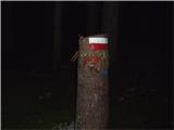 2
2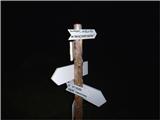 3
3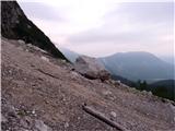 4
4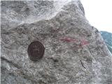 5
5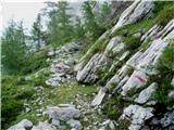 6
6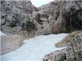 7
7 8
8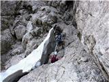 9
9 10
10 11
11 12
12 13
13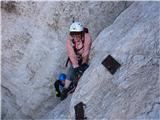 14
14 15
15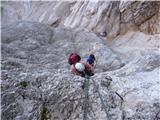 16
16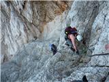 17
17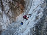 18
18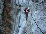 19
19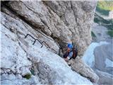 20
20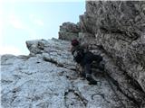 21
21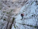 22
22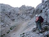 23
23 24
24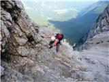 25
25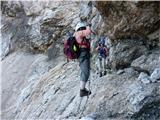 26
26 27
27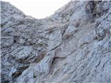 28
28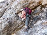 29
29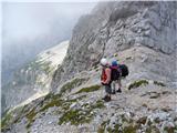 30
30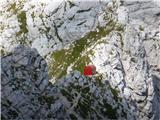 31
31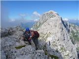 32
32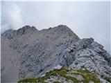 33
33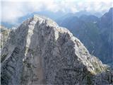 34
34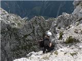 35
35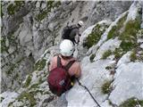 36
36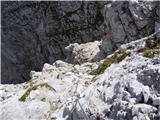 37
37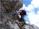 38
38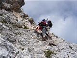 39
39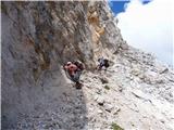 40
40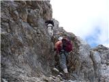 41
41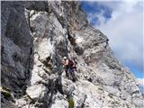 42
42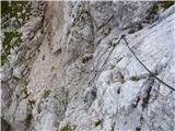 43
43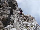 44
44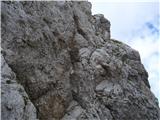 45
45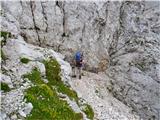 46
46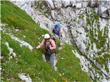 47
47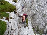 48
48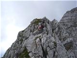 49
49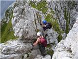 50
50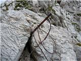 51
51 52
52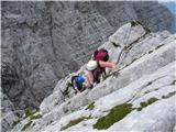 53
53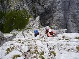 54
54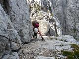 55
55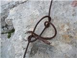 56
56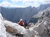 57
57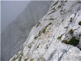 58
58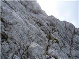 59
59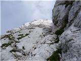 60
60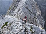 61
61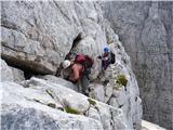 62
62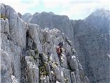 63
63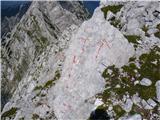 64
64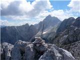 65
65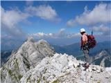 66
66
Discussion about the trail Belopeška jezera - Strug (Via della Vita - Vevnica - Strug)
|
| meta.nacy8. 10. 2010 |
Od kdaj so te slike,a ni Vevnica zaprta?
|
|
|
|
| bagi9. 10. 2010 |
@meta.nancy. Poglej pod *Opozorila*. Avgust 2010, torej slaba 2 meseca. Obvestilo, da je pot zaprta, je tam že dalj časa, nanaša se pa na gornji del ferate kjer moraš prosto prečiti skalno stopnjo (slika 24 in 25). Če imaš izkušnje, ne bo problema.
LP Bagi
|
|
|
|
| meta.nacy11. 10. 2010 |
Bagi,preveč se mi je mudilo gledat te super slike,da sm čist spregledala*Opozorila*,fenks za odg.CAO! 
|
|
|
|
| bagi11. 10. 2010 |
@meta.nancy, ni problema . Če rabiš še kak info,kar na dan z njim. Pozdrav, Bagi
|
|
|
|
| Whbross14. 08. 2011 |
Hvala za odličen opis in foto dokumentacijo. Prav ta prispevek je bil razlog, da sva se včeraj s kolegom odpravila na krožno turo; Belopeška jezera, Vevnica, Strug, Ponce, Belopeška jezera. Ferata je v spodnjem delu odlično opremljena, zgoraj uradno zaprta (problem niso plošče, ki jih omenja prispevek, temveč del med križpotjem za bivak in vršnim grebenom). Od Vevnice do njene škrbine je pot odlično zavarovana (z izjemo dveh nekajmetrskih nezavarovanih delov), naprej pa zahteva pot popolno zbranost, saj so več ali manj vse jeklenice potrgane oz nezanesljive. Za iskušenega gornika bo omenjena tura prava poslastica, za gornika nevajenega velikih izpostavljenosti pa lahko prav mučna izkušnja. Časovnica cca 8-10ur. Srečno in previdno!
|
|
|
|
| _sandra_16. 10. 2011 |
tole pa so slike ja, dobri ste, da vam rata kaj takega preplezat, sploh glede na to, da na določenih težkih delih ni varoval
|
|
|
|
| ljubitelj gora16. 10. 2011 |
Pot iz Belopeški jezer do Vevnice (ferrata) je bila obnovoljena, slike so še stare. Od Vevnice do Ponc pa je stara zgodba, potrgana varovala.
|
|
|
|
| iomejc14. 08. 2012 |
Super slike, super prispevek! Temu se pa reče prava kraljevska tura!
Za trenutne razmere pa ne vem nič, saj sem tole le od daleč opazoval (z V. Ponce). Kapo dol vsem, ki se tega lotite!
|
|
|
|
| redbull1. 10. 2012 |
pri tej poti od belopeških proti vevnici, naprej do struga. Najlažji spust nazaj k jezerom me zanima? da greš naprej proti poncam, pa od tam po lažji poti k jezerom? zanima me če imam prav,al je kaka druga pot(ker po tej poti, ko se gre gor, ne bi šel nazaj), lp
hvala
dejan
|
|
|
|
| ljubitelj gora1. 10. 2012 |
Greš naprej po grebenu do razpotja med Srednjo in Visoko Ponco, tam se lahko spustiš proti jezerom ali pa greš še na Visoko Ponco in se iz vrha spustiš po kratki ferrati, ki se združi z drugo pot. Je pa dolga tura kar kakšnih 10-11 ur z Visoko Ponco vred, 2 ferrati.
|
|
|
|
| turbo1. 10. 2012 |
Najlažje je prek Mangrta in mimo Nogare, najkrajše pa po isti dol. Ni tak bav bav, ne eno ne drugo.
|
|
|
|
| redbull1. 10. 2012 |
v mislih imam to kar si rekel ti matej-to jst mislim,,sam fajn je da ni megle, če je megla se lahk hiter kje zaserješ od vevnice proti poncam,nč markiran. Če se pojavi kateri vikend sončno lepo vreme, potem grem. Se lahk kdo pridruži, če bo v oktobru še lepa sobota, ker potem bo že sneg.
Sem pa hodu že 13 ur, Jalovec in Mangart skupi(tko da sn navajen dolgih tur-1- dan)
lp
dejan
|
|
|
|
| redbull7. 10. 2012 |
zdravo
sestop iz struga(kot zasilna varjanta kot piše zgoraj v opisu). ne vem kdo te poti opisuje, čist lepa pot in ni redkih rdečih pik ampak ogromno pik, lepo markirAN.
Preveč strašite ljudi,pohodnike, pol pa eni to sploh ne obiščejo
lp
|
|
|
|
| ljubitelj gora7. 10. 2012 |
Ti si šel po drugi poti, namreč ferrata Via della Vita se je nahajala bolj desno. Si pa prišel gor med Ponco in Strugom, predvidevam, da je ta pot težja od ferrate na Vevnico.
|
|
|
|
| mukl17. 10. 2014 |
Brutalno
|
|
|
|
| Janez_Radovljica9. 08. 2017 |
živijo, Včeraj prek Vevnice na Strug in nato proti Poncam. De la Vita je v dobrem stanju, s tem da mi je ob izstopu iz zajl uspelo gladko falit rdečo puščico v levo - sledil sem rdečim pikam v desno in prišel na pot 5minut desno od smerokaza. Obiskal bivak in se nato vzpel na Vevnico. Lojtra bo očitno morala počakat na naslednji obisk.  Sestop v škrbino je tudi v redu, edino ena od zarjavelih zajl, ki vodi okrog vogala (in brez katere si ne predstavljam priti tam mimo),že zelo 'hrusta' in ji dam največ še kako leto. Od Struga naprej pa pot relativno normalna. Čudovit dan v gorah, srečal samo 3 pohodnike na Vevnici ter 1 pohodnico na z.ponci. Aja, še vprašanje za poznavalce - kje točno se zavije dol po Kugy-ju? A je to zgoraj omenjeni zasilni sestop,kjer na plošči piše 2uri do Zacchi-ja?
|
|
|
|
| redbull9. 08. 2017 |
Točno tam pri tabli 2h Zacchi. Pot poteka ob skalnatem delu in ne po melišču. Redke rdeče pike in kakšen možic se najde. Priporočljiva za vzpon, vsaj sprva da se pot dobro pozna,
srečno
|
|
|
|
| sebahambi15. 08. 2017 |
Prehodil včeraj to pot in ne priporočam sestopa po kugyevi vsaj ne brez vrvi.Tko kot je povedal že Redbull.Boljše je iti v obratni smeri
Lp
|
|
|
|
| KJ16. 08. 2017 |
Prehodil-a 15.08.2017 - super tura - po grebenu vroče/brez sapice. Varovala OK, edino sestop iz Velike Ponce po ferati (po ITA strani) nama je kmalu od vrha vzel nekaj minut, ker sva iskala smer poti  - miniaturni možicli).
|
|
|