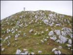
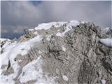
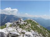
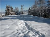
 | Podljubelj (Lajb) - Begunjščica
Begunjščica is a mountain range in Karawanks east of Stol. The highest peak is Veliki vrh, which at over 2000m offers a beautiful view of central...
3 h 30 min |
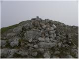
 | Ljubelj - Begunjščica (via Zelenica)
Begunjščica is a mountain range in Karawanks east of Stol. The highest peak is Veliki vrh, which at over 2000m offers a beautiful view of central...
3 h 50 min |
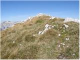
| Tinčkova koča - Begunjščica
Begunjščica is a mountain range in Karawanks east of Stol. The highest peak is Veliki vrh, which at over 2000m offers a beautiful view of central...
3 h 15 min |
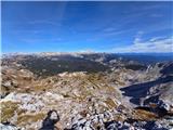
 | Tinčkova koča - Begunjščica (via Poljška planina)
Begunjščica is a mountain range in Karawanks east of Stol. The highest peak is Veliki vrh, which at over 2000m offers a beautiful view of central...
3 h 50 min |
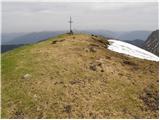
 | Ljubelj - Hochstuhl/Stol (upper way)
At 2236 m, Stol is the highest peak in the Karavanke Mountains. From the summit, which has a registration box and a stamp, we have a beautiful vi...
4 h 50 min |
| Johannsenruhe - Hochstuhl/Stol (via Klagenfurter Hütte)
At 2236 m, Stol is the highest peak in the Karavanke Mountains. From the summit, which has a registration box and a stamp, we have a beautiful vi...
3 h 45 min |
| Ljubelj - Hochstuhl/Stol (via Vatelca or Skleda)
At 2236 m, Stol is the highest peak in the Karavanke Mountains. From the summit, which has a registration box and a stamp, we have a beautiful vi...
5 h |
 | Planina Zajavornik - Viševnik
Viševnik is a 2050 m high mountain rising north-west of Rudno polje on Pokljuka. From the top of the peak where the stamp is located, you have a ...
3 h 30 min |
 | Uskovnica (Lom) - Viševnik (via Srenjski preval)
Viševnik is a 2050 m high mountain rising north-west of Rudno polje on Pokljuka. From the top of the peak where the stamp is located, you have a ...
3 h 15 min |
 | Ljubelj - Vertatscha/Vrtača
Vertatscha is a 2181 m high peak located to the east of Stol. From the top of the peak, on which stands a large wedge, we have a beautiful view o...
3 h 30 min |
| Tinčkova koča - Vertatscha/Vrtača (via Smuška planina in saddle Šija)
Vertatscha is a 2181 m high peak located to the east of Stol. From the top of the peak, on which stands a large wedge, we have a beautiful view o...
3 h 30 min |
| Trate / Johannsenruhe - Vertatscha/Vrtača
Vertatscha is a 2181 m high peak located to the east of Stol. From the top of the peak, on which stands a large wedge, we have a beautiful view o...
4 h |
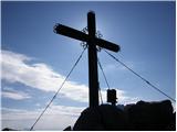
 | Gozd - Storžič (through southwest groove)
Storžič is a 2132 m high mountain located in the western part of the Kamink Savinja Alps. From the top with a cross there are beautiful views of ...
4 h 50 min |
 | Markova raven - Kalška gora (on marked path)
Kalška gora is located between Kalški greben and Kokrsko sedlo. From the top, which is covered with grass, there is a beautiful view towards the ...
5 h 30 min |
| Kokra (Roblek) - Kalška gora (via Kalce)
Kalška gora is located between Kalški greben and Kokrsko sedlo. From the top, which is covered with grass, there is a beautiful view towards the ...
4 h 30 min |
 | Planina Kuhinja - Krn (via jezero v Lužnici)
At 2244 m, Krn is the highest peak of the Krn Mountains, a mountain range that rises steeply above the central part of the Soča River. From the s...
4 h 45 min |
 | Planina Kuk - Tolminski Kuk
Tolminski Kuk is the highest peak of the Lower Bohinj Mountains. The summit, which has a registration box, offers a very nice view. From the top ...
4 h 30 min |
 | Tolminske Ravne - Tolminski Kuk (via Dolina pod Ploščo)
Tolminski Kuk is the highest peak of the Lower Bohinj Mountains. The summit, which has a registration box, offers a very nice view. From the top ...
4 h 35 min |
 | Planina Blato - Zasavska koča na Prehodavcih (via Štapce)
Zasavska koča na Prehodavcih is located on a scenic peak above the Triglav Lakes Valley. The hut, which is open in the summer season, offers a be...
5 h 15 min |
 | Povlje - Bašeljski vrh
Bašeljski vrh is a 1744 m high mountain located between Mali Grintovec and Storžič. From the top, where there is a bench and a registration box w...
4 h |
| Laško - Bašeljski vrh (via Sveti Lovrenc)
Bašeljski vrh is a 1744 m high mountain located between Mali Grintovec and Storžič. From the top, where there is a bench and a registration box w...
3 h 45 min |
 | Ljubelj - Prešernova koča na Stolu (upper way)
Prešernova koča na Stolu, is located just a few metres below the summit of the 2198 m high Mali Stol. From the hut or the nearby Mali Stol, we ha...
4 h 45 min |
| Ljubelj - Prešernova koča na Stolu (via Vatelca or Skleda)
Prešernova koča na Stolu, is located just a few metres below the summit of the 2198 m high Mali Stol. From the hut or the nearby Mali Stol, we ha...
4 h 55 min |
 | Trate / Johannsenruhe - Prešernova koča na Stolu (via Celovška koča)
Prešernova koča na Stolu, is located just a few metres below the summit of the 2198 m high Mali Stol. From the hut or the nearby Mali Stol, we ha...
3 h 40 min |
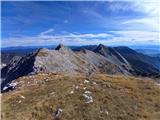
 | Kokra (Roblek) - Kalški greben
Kalški greben is 2224 m high and is the highest peak of the eponymous ridge. The summit, which has a registration box and a stamp, offers a beaut...
3 h 55 min |
 | The Kot Valley - Visoka Vrbanova špica (via Staničev dom)
Visoka Vrbanova špica, is located at the extreme south-western part of the ridge rising above the Kot and Vrata valleys, and higher up between th...
4 h 20 min |
 | Ravenska Kočna - Ledinski vrh (hunter's way)
The mountain is located above Jezersko, on the border with Austria. From the top there is a beautiful view towards the neighbouring Baba to the n...
3 h 30 min |
| Koča pod slapom Rinka - Ledinski vrh
The mountain is located above Jezersko, on the border with Austria. From the top there is a beautiful view towards the neighbouring Baba to the n...
3 h 30 min |
 | Velacher Kotschna/Belska Kočna - Ledinski vrh
The mountain is located above Jezersko, on the border with Austria. From the top there is a beautiful view towards the neighbouring Baba to the n...
3 h 45 min |
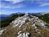
 | Matizovec - Veliko Kladivo
Veliko Kladivo is a 2094 m high peak in the Košuta Ridge, the longest Slovenian ridge. From the summit, which has a registration box and a stamp,...
3 h 20 min |
| Dolina - Veliko Kladivo
Veliko Kladivo is a 2094 m high peak in the Košuta Ridge, the longest Slovenian ridge. From the summit, which has a registration box and a stamp,...
3 h 30 min |
| Dolina - Veliko Kladivo (past the chapel)
Veliko Kladivo is a 2094 m high peak in the Košuta Ridge, the longest Slovenian ridge. From the summit, which has a registration box and a stamp,...
3 h 30 min |
 | Povlje - Mali Grintovec (via Bašeljski vrh)
Mali Grintovec is a lookout mountain located to the east of Storžiča. From the top, where there is a registration box, a stamp and a nice bench, ...
4 h 45 min |
| Laško - Mali Grintovec (via Sveti Lovrenc)
Mali Grintovec is a lookout mountain located to the east of Storžiča. From the top, where there is a registration box, a stamp and a nice bench, ...
4 h 30 min |
 | Povlje - Mali Grintovec
Mali Grintovec is a lookout mountain located to the east of Storžiča. From the top, where there is a registration box, a stamp and a nice bench, ...
4 h 30 min |
 | Planina Kuhinja - Batognica
Batognica is a 2164 m high mountain, which was affected by the Mine War during World War I. Remnants of the mine war between the Italians and the...
3 h 20 min |
| Koča na planini Kuhinja - Batognica
Batognica is a 2164 m high mountain, which was affected by the Mine War during World War I. Remnants of the mine war between the Italians and the...
3 h 15 min |
 | Bele Vode - Jerebica
Jerebica is a mountain located on the border between Slovenia and Itali, between Moznica and the Jezersko Valley. The summit, which has a registr...
3 h 30 min |
 | Planina Blato - Mala Zelnarica (via Štapce)
Mala Zelnarica is a 2310 m high peak located between the Triglav Lakes Valley and the Za Kopica Valley. The summit, which has a registration box ...
5 h 15 min |
 | Hotel Plesnik - Strelovec (via Plesnikova planina)
This scenic peak is located between two Alpine valleys, the Logarska dolina and Robanov Kot. The view from the top is the most beautiful of the m...
3 h 30 min |
 | Tinčkova koča - Bielschitza/Svačica (via Smokuška planina)
Bielschitza is a less prominent peak in the main ridge of the Karavanke. It is located between Vertatscha and Stol and is slightly offset to the ...
3 h 30 min |
 | Ljubelj - Bielschitza/Svačica (upper path)
Bielschitza is a less prominent peak in the main ridge of the Karavanke. It is located between Vertatscha and Stol and is slightly offset to the ...
4 h 20 min |
| Ljubelj - Bielschitza/Svačica (via Vatelca or Skleda)
Bielschitza is a less prominent peak in the main ridge of the Karavanke. It is located between Vertatscha and Stol and is slightly offset to the ...
4 h |
 | Planina Storeča raven - Vogel (below the slopes of Orlove glave)
When you hear the name Vogel, many people first think of the Vogel ski resort, which is located near the peak of the same name. From the north si...
3 h 45 min |
 | Planina Storeča raven - Vogel (via upper station of chairlift Zadnji Vogel)
When you hear the name Vogel, many people first think of the Vogel ski resort, which is located near the peak of the same name. From the north si...
3 h 45 min |
 | Žabnice/Camporosso in Valcanale - Kamniti lovec / Cima del Cacciatore
Kamniti lovec is a popular excursion point above Trbiz. It is well visited due to its short access, which is shortened by a cable car to Višarje....
3 h 15 min |
 | Koča pod slapom Rinka - Velika (Koroška) Baba
Velika is a 2127 m high mountain on the border ridge above the Ravenská Kočna valley on the Slovenian side and above the Bela valley (Belska Kočn...
4 h 30 min |
| Ravenska Kočna - Velika (Koroška) Baba (on hunting path and over Jezersko sedlo)
Velika is a 2127 m high mountain on the border ridge above the Ravenská Kočna valley on the Slovenian side and above the Bela valley (Belska Kočn...
4 h 30 min |
 | Planina Kuk - Vrh nad Škrbino (direct way)
Vrh nad Škrbino is the easternmost two-thousandth peak in the ridge of the Lower Bohinj Mountains. From the top there is a very nice view of the ...
3 h 15 min |
| Tolminske Ravne - Vrh nad Škrbino (on mule track and direct way)
Vrh nad Škrbino is the easternmost two-thousandth peak in the ridge of the Lower Bohinj Mountains. From the top there is a very nice view of the ...
4 h |
 | Weissensee - Eckwand (via Almspitz)
Eckwand is a 2221-metre peak in the Latschur Group. The grassy summit on which the cross stands offers a beautiful view of Gailtaler Alps, Carnic...
4 h 45 min |
 | Untere Valentinalm - Rauchkofel
To the north of Monte Coglians, the highest peak of Carnic Alps, is the 2460 m high Rauchkofel. From the top, where a cross and a signing box sta...
3 h 15 min |
| Untere Wolayeralm - Rauchkofel
To the north of Monte Coglians, the highest peak of Carnic Alps, is the 2460 m high Rauchkofel. From the top, where a cross and a signing box sta...
3 h 45 min |
 | Planina Kuk - Zeleni vrh
Zeleni vrh is a 2052 m high mountain located east of the highest peak of the Lower Bohinj Mountains. The grassy peak, which descends precipitousl...
4 h 5 min |
 | Tolminske Ravne - Zeleni vrh (via Dolina pod Ploščo)
Zeleni vrh is a 2052 m high mountain located east of the highest peak of the Lower Bohinj Mountains. The grassy peak, which descends precipitousl...
4 h 10 min |
 | Čadrg - Tolminski Migovec
Tolminski Migovec is a mountain 1881 m high. Its western slope above the Tolmin valley is the steepest and most picturesque. The southern slope i...
3 h 30 min |
 | Pala Barzana - Monte Raut (CAI 967)
Raut is a 2025 m high limestone lookout over the Friuli plain and the second highest peak of the ridge between Lakes Barcis and Selva. Its striki...
3 h 45 min |
 | Kesselfall - Höhenburg
Höhenburg is a 2108 metre high mountain in the Glockner mountain group in the High Tauern. It is located next to the Moserboden reservoir. From t...
3 h 50 min |
 | Weißenbach - Spitzegel / Negal (25d)
Spitzegel or. Negal (in Slovene) is a 2119 m high mountain in Gailtal Alps in Austria.The narrow ridge is a logical continuation of Dobrač / Dobr...
3 h 40 min |
 | Collina - Cima Ombladet (path 141)
Cima Ombladet is a 2255-metre-high mountain in Carnic Alps, east of Forni Avoltri. From the top of the hill, where there is a small cross, there ...
3 h 20 min |
 | Parkplatz Tappenkarweg - Weißgrubenkopf (Parkplatz Tappenkarweg - Weißgrubenkopf)
...
3 h 30 min |
| Koča pod slapom Rinka - Ledenik pod Skuto
...
4 h 10 min |