 | Planina Podvežak - Planjava (via Srebrno sedlo)
Planjava is a small mountain range to the east of Kamnik saddle. It has two peaks, one eastern and one western. There is a marked trail to the ea...
4 h 15 min |
 | Kraljev dol - Planjava (via Srebrno sedlo)
Planjava is a small mountain range to the east of Kamnik saddle. It has two peaks, one eastern and one western. There is a marked trail to the ea...
4 h 30 min |
 | Ravne - Mittagskogel/Kepa
Kepa, also Jepa, or Mittagskogel in German, is a scenic mountain in the western Karawanks, located on the border ridge between Slovenia and Austr...
4 h 15 min |
 | Iličev rovt / Illitsch Rauth - Mittagskogel/Kepa (path 680)
Kepa, also Jepa, or Mittagskogel in German, is a scenic mountain in the western Karawanks, located on the border ridge between Slovenia and Austr...
3 h |
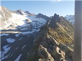
 | Planina Podvežak - Ojstrica (via Kocbekov dom)
Ojstrica, named after its sharp shape, rises steeply above the Korošica River, the Logar Valley and Robanov Kot. From the top, where the registra...
4 h |
 | Planina Podvežak - Ojstrica (via Mala Ojstrica)
Ojstrica, named after its sharp shape, rises steeply above the Korošica River, the Logar Valley and Robanov Kot. From the top, where the registra...
3 h 30 min |
| Planina Ravne - Ojstrica (via Mala Ojstrica)
Ojstrica, named after its sharp shape, rises steeply above the Korošica River, the Logar Valley and Robanov Kot. From the top, where the registra...
4 h 15 min |
| Kraljev dol - Ojstrica (via Mala Ojstrica)
Ojstrica, named after its sharp shape, rises steeply above the Korošica River, the Logar Valley and Robanov Kot. From the top, where the registra...
3 h 45 min |
| Kraljev dol - Ojstrica (via Kocbekov dom)
Ojstrica, named after its sharp shape, rises steeply above the Korošica River, the Logar Valley and Robanov Kot. From the top, where the registra...
4 h 15 min |
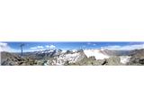
 | Kriška planina - Kalški greben (via Zvoh)
Kalški greben is 2224 m high and is the highest peak of the eponymous ridge. The summit, which has a registration box and a stamp, offers a beaut...
4 h 10 min |
| Dom na Gospincu - Kalški greben (via Zvoh)
Kalški greben is 2224 m high and is the highest peak of the eponymous ridge. The summit, which has a registration box and a stamp, offers a beaut...
4 h 10 min |
| Planina Jezerca - Kalški greben (via Dom na Krvavcu and Zvoh)
Kalški greben is 2224 m high and is the highest peak of the eponymous ridge. The summit, which has a registration box and a stamp, offers a beaut...
4 h 25 min |
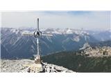
 | Pod Krnico - Koschutnikturm (Košutnikov turn) (eastern way)
Košutna Turn is the highest peak in Slovenia's longest ridge, the Košuta. From the top, you have a beautiful view of the entire ridge. Austria an...
2 h 30 min |
 | Jochalm - Reißkofel (235-1)
Reißkofel is a 2371 metre high mountain in the Zilj Alps. The summit on which the cross stands also has a registration box. The view from the top...
3 h |
 | Jochalm - Reißkofel (path 235)
Reißkofel is a 2371 metre high mountain in the Zilj Alps. The summit on which the cross stands also has a registration box. The view from the top...
3 h 25 min |
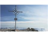
 | Göriach - Scharnock
Scharnock is a scenic peak located in the Schladminger Tauern mountain group. From the summit on which the cross stands, there is a beautiful vie...
3 h 30 min |
 | Plockenpass - Monte Floriz
Monte Floriz is a 2184m high grassy peak located south of the Marinelli hut. From the summit there is a very fine view of the Coglians group, and...
3 h |
 | Sella Nevea - Monte Bila pec
White oven, or Italian. Monte Bila pec is a 2146 m high mountain located to the north of the main Kanin ridge. From the top, where there is a reg...
2 h 45 min |
 | Planina Pecol - Strma peč / Monte Cimone (path 640 via notch Vandul)
Strma peč is located to the west of Jôf di Montasio, specifically between the Reklanica and Dunja valleys. From the summit, where the bivouac onc...
4 h |
 | La Crusc - Lavarella
Lavarella (aka La Varella) is the second highest peak in the Lavarella mountain group. From the summit on which the cross stands, you have a very...
4 h |
 | La Crusc - Lavarella (western summit)
The Lavarella West Peak is a 3,034-metre-high mountain in the Lavarella mountain group. The West Peak is slightly lower than the East Peak, but t...
4 h |
 | Passo Gardena - Cima Pisciadu (path 666)
Cima Pisciadu or Pisciadu Spitze is a 2985 metre high peak in the Sella mountain group. The mountain is located in the northern part of the group...
3 h 40 min |
 | Ristorante Pietofana - Cima Formenton
Cima Formenton is a 2830 m high peak in the Tofana mountain group. The mountain is located to the north of the better known Tofana di Dentro, and...
3 h 40 min |
 | Passo Campolongo - Col di Lana
Col di Lana also known in Italian as Col di Sangue (Blody Mountain), is a 2,452-metre-high mountain located to the west of the Valparola and Falz...
4 h 20 min |
 | Rifugio Ra Stua - Croda del Beco / Seekofel
Croda del Beco (German: Seekofel, Ladin: Sass dla Porta) is a 2,810-metre-high mountain rising steeply above Lago di Braies (Pragser Wildsee). It...
3 h 35 min |
 | Fiames - Punta Fiames
Punta Fiames is a 2240-metre peak located north of Cortina d'Ampezzo. The mountain is particularly popular among those who like protected climbin...
3 h 30 min |
 | Bergheimat - Dachskofel (via Scharnik)
Dachskofel is a 2373m high mountain in Hohe Tauern in Austria above the city of Irschen and near the Lamnitzsee. A wooden cross is placed on the ...
3 h 50 min |
 | Saddle Sedlo - Bobotov kuk
Bobotov kuk is the highest peak of Durmitor. It is the highest peak of the XXXXXX range. The southern approaches are the shortest and the eastern...
3 h |
 | Dolina Dobri do - Bobotov kuk
Bobotov kuk is the highest peak of Durmitor. It is the highest peak of the XXXXXX range. The southern approaches are the shortest and the eastern...
2 h 45 min |
 | Passo Campolongo - Piz Lech Dlace (Lichtenfels)
Peak Piz Lech Dlace (German: Eisseespitze, Italian: Piz Lago Gelato) is located above Lech Dlace Lake (German: Eissee, Italian: Lago Gelato) to t...
3 h 55 min |
 | Passo di Sant'Antonio - Monte Aiarnola (via normale)
Monte Aiarnola is a mountain in the easternmost part of the Sexten Dolomites group. It offers a fine view of the western Carnic Alps, the Marmaro...
3 h 30 min |
 | Cima Sappada - Creton di Tul
Creton di Tul is a 2288 meter high mountain in a mountain group Pesarina Dolomites in the Carnic Alps in Italy, south of a city of Sappada and ju...
3 h 30 min |
 | Cima Sappada - Creta Forata
Creta Forata is a 2462 meter high mountain in a mountain group of the Pesarina Dolomites in the Carnic Alps in Italy, south of a city of Sappada....
4 h |
 | Kühtai - Finsteltaler Schartenkopf (zahodni pristop iz Kühtaia in čez sedlo Finstertal)
(Finsteltaler) The Schartenkopf is an peak in the mountains above Kühtai, which is rather nondescript from the Finstertal saddle, from where it i...
4 h |
 | Oberissalm - Rinnenspitze (običajni pristop mimo Franz-Senn-Hütte)
Rinnerspitze is a beautiful conical mountain rising above the lake of the same name. Although it does not stand out for its height or the difficu...
3 h 45 min |
 | Oberissalm - Vordere Sommerwand (normal path)
The Sommerwand is a relatively long ridge rising like a mighty rock barrier above the upper part of the Oberbergtal valley, hiding from the valle...
2 h 40 min |
 | Sella di Razzo - Clapsavon (via 210 & 212)
Clapsavon is a 2462 m high mountain in Carnic Alps in Italy, and it is situated just short of 1 hour hiking distance to the west from Monte Biver...
3 h |
 | Sella di Razzo - Bivera (via Forcella Chiansaveit, Monte Clapsavon, Forcella de Bivera)
Monte Bivera is a 2474 m high mountain in Carnic Alps in Italy, and it is situated just short of 1 hour hiking distance to the east from Monte Cl...
4 h |