 | Gozd - Tolsti vrh (Ovčja pot over Kriška gora)
Tolsti vrh, located to the west of Storžič, is also the highest peak of the Kriška Gora, a mountain range rising steeply above the central Gorenj...
2 h 30 min |
 | Tominčev slap Waterfall - Dobrča
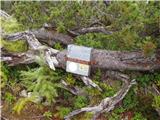
Dobrča is a 1634 m high mountain located between Begunje and Tržič. From the top, where the registration box with the stamp is located, we can se...
3 h |
 | Draga - Dobrča (via Ledena trata)
Dobrča is a 1634 m high mountain located between Begunje and Tržič. From the top, where the registration box with the stamp is located, we can se...
3 h |
 | Hudi Graben - Dobrča (via Lešanska planina)
Dobrča is a 1634 m high mountain located between Begunje and Tržič. From the top, where the registration box with the stamp is located, we can se...
2 h 35 min |
| Hudi Graben - Dobrča
Dobrča is a 1634 m high mountain located between Begunje and Tržič. From the top, where the registration box with the stamp is located, we can se...
2 h 30 min |
 | Grahovše - Veliki Javornik (Ženiklovec)
Veliki Javornik or Ženiklovec is a 1716 m high peak located between Storžič and Stegovnik. From the grassy summit, where the registration box is ...
2 h 45 min |
 | Tržiški graben - Veliki Javornik (Ženiklovec)
Veliki Javornik or Ženiklovec is a 1716 m high peak located between Storžič and Stegovnik. From the grassy summit, where the registration box is ...
2 h 30 min |
| Grahovše - Veliki Javornik (Ženiklovec) (via Rekar)
Veliki Javornik or Ženiklovec is a 1716 m high peak located between Storžič and Stegovnik. From the grassy summit, where the registration box is ...
2 h 45 min |
 | Smrečje - Pečovnik (survey point 1668) (by road)
Pečovnik) is a 1668 m high mountain located between Plešivec (1801 m) and Virnik's Grintovec (1654 m). The grassy peak, located on the border bet...
2 h 45 min |
 | Polja - Ofen/Peč (via Petelinjek)
Peč (also Tromeja), in Italian Monte Forno and in German Dreiländereck or Ofen, is a 1508 m high peak located on the tri-border between Slovenia,...
2 h 45 min |
 | Planina pod Golico - Klek (via Ovčarska koča)
Klek is a 1753 m high mountain located between Rosenkogel and the more famous Golica. The summit, which borders between Slovenia and Austria, off...
3 h |
 | Log - Vošca
Vošca is a 1737 m high peak located west of Trupe's Non. From the grassy summit, we have a beautiful view of Julian Alps, the western Karawanks, ...
2 h 30 min |
 | Srednji Vrh - Vošca (via Zajčnik)
Vošca is a 1737 m high peak located west of Trupe's Non. From the grassy summit, we have a beautiful view of Julian Alps, the western Karawanks, ...
2 h 35 min |
 | Srnjak - Vošca
Vošca is a 1737 m high peak located west of Trupe's Non. From the grassy summit, we have a beautiful view of Julian Alps, the western Karawanks, ...
2 h 45 min |
 | Bela Peč - Vivodnik (past peak Seduc)
At 1508 m, Vivodnik is the highest peak of the Menina mountain pasture, a plateau rising south of Gornji Grad. From the top, where there is a sma...
4 h 20 min |
| Bela Peč - Vivodnik (via Ovčje jame)
At 1508 m, Vivodnik is the highest peak of the Menina mountain pasture, a plateau rising south of Gornji Grad. From the top, where there is a sma...
4 h 25 min |
 | Source of Ljubija - Smrekovec (by road)
Smrekovec is a volcanic mountain on the eastern edge of the Smrekov Mountains. The extensive grassy summit, on which stands a pyramid with a regi...
2 h 30 min |
 | Dolina potoka Žep - Komen
At 1684m, Komen is the highest peak of the Smrekov Mountains, a mountain range bordering Styria and Carinthia. From the top, in good weather, we ...
2 h 30 min |
 | Mislinjski graben (Pestotnik) - Rogla (via Ostruščica)
Rogla is the peak in the middle of the ski resort of the same name. The summit is woded with a small clearing on which stands a lookout tower. Th...
3 h |
 | Smrečje - Pečovnik (by road)
Pečovnik is a 1640 m high peak located in the mountain ridge between Košuta and Virnik Grintovec. The partially vegetated peak offers a beautiful...
2 h 35 min |
 | Ivarčko jezero - Uršlja gora (Plešivec) (Grofovska pot)
Uršlja gora or Plešivec is a lookout mountain between Slovenj Gradec and Črna na Koroškem. On the top or just below it stands the Church of St Ur...
2 h 50 min |
 | Trbiž / Tarviso - Svete Višarje / Monte Lussari (on transport road)
Svete Višarje is a pilgrimage site for Slavs, Germans and Romans. As early as the 16th century, the mountain was called the God's Way of the Thre...
3 h 25 min |
 | Jevšček - Monte Mataiur/Matajur
Monte Mataiur is a scenic mountain located on the border between Slovenia and Itali. From the top, you have a beautiful view of the Kobarid or Br...
2 h 30 min |
 | Poljšica pri Gorjah (Zatrata) - Galetovec (on footpath)
Galetovec is an undistinguished peak in the south-eastern part of the Pokljuka plateau. From the summit, which has a registration box, there is a...
2 h 35 min |
 | Draga - Šentanski vrh (via Ledena trata)
Šentanski vrh, located in the Dobrča mountain range, only 5 minutes away from the main peak, offers a beautiful view of the central Karawanks, th...
3 h 5 min |
 | Hudi Graben - Šentanski vrh (via Lešanska planina)
Šentanski vrh, located in the Dobrča mountain range, only 5 minutes away from the main peak, offers a beautiful view of the central Karawanks, th...
2 h 40 min |
| Hudi Graben - Šentanski vrh
Šentanski vrh, located in the Dobrča mountain range, only 5 minutes away from the main peak, offers a beautiful view of the central Karawanks, th...
2 h 35 min |
 | NC Planica - Glave (by ski jumping hill)
Glave are an undistinguished side ridge of the Ponce, rising steeply to the west of Planica. The highest peak of Glav, which measures 1760m, is c...
2 h 30 min |
| Rateče (Ledine) - Glave
Glave are an undistinguished side ridge of the Ponce, rising steeply to the west of Planica. The highest peak of Glav, which measures 1760m, is c...
2 h 50 min |
 | Gozd Martuljek - Kurji vrh
Kurji vrh is a little visited mountain located southeast of Kranjska Gora. From the summit, which has a registration box, we have a beautiful vie...
3 h |
 | Grant - Jehlc (Špičasta kupa)
For Jehlc we will get different names on different maps, which also differ in height. The locals call the peak Jehlc (1625 m), but on more recent...
2 h 45 min |
| Stržišče - Jehlc (Špičasta kupa)
For Jehlc we will get different names on different maps, which also differ in height. The locals call the peak Jehlc (1625 m), but on more recent...
3 h 30 min |
 | Spodnje Danje - Altemaver (Ratitovec)
Altemaver is the highest peak of Ratitovec at 1678 m. The grassy peak offers a beautiful view of Julian Alps, Jelovica, Karawanks, Kamnik Savinja...
2 h 30 min |
 | Spodnje Danje - Kremant (Ratitovec)
Kremant is a 1654 m high peak located in the western part of Ratitovec. From the top, where a stamp is attached to a metal pole, we have a beauti...
2 h 30 min |
 | Srnjak - Tamarča
Tamarča is a lesser known peak located northwest of Voška. The summit, surrounded by a larch forest, offers a beautiful view of the Martuljka gro...
2 h 30 min |
 | Radovna - Vošni vrh
Vošni vrh is a 1621 metre high mountain located in the ridge of mountains starting at Radovna and ending at Tosc. The peak itself is located in a...
3 h |
 | Kneške Ravne - Grušnica (via Planina na Kalu)
Grušnica is a 1570 m high peak located between Čadrg, the Tolmin valley and Tolminski Ravne. From the top, which descends steeply towards the riv...
4 h 30 min |
 | Javorje - Gradovec (path over Glin)
Gradovec is a 1692 m high peak located north of the ridge of the Lower Bohinj Mountains, above mountain pasture Poljana. From the summit, where d...
3 h 10 min |
 | Jasna - Visoka peč (via Mojčin dom)
Visoka peč is a 1,749-metre-high mountain located south-west of Ciprnik. From the top, which descends steeply towards Planica and on which a smal...
3 h 30 min |
| Kranjska Gora - Visoka peč (via Bedančev dom)
Visoka peč is a 1,749-metre-high mountain located south-west of Ciprnik. From the top, which descends steeply towards Planica and on which a smal...
3 h 25 min |
 | Mislinjski graben (Pestotnik) - Ostruščica
Ostruščica is a 1498 m high peak located west of the ski slopes at Rogla....
2 h 30 min |
 | Trbiž / Tarviso - Florjanka / Monte Florianca (on transport road)
Florjanka is a 1,653-metre-high mountain on the Italian side of the Julian Alps. At the top or just below it, there is a reservoir for snowmaking...
2 h 30 min |
 | Rebrca / Rechberg - Stara gora / Altberg (via Bukovnik)
Stara gora is a 1552 m high peak located north-east of Hochobir, the highest peak of the Obir. A wooden cross and a bench are placed on the summi...
2 h 50 min |
| Rebrca / Rechberg - Stara gora / Altberg (via Rokov vrh)
Stara gora is a 1552 m high peak located north-east of Hochobir, the highest peak of the Obir. A wooden cross and a bench are placed on the summi...
3 h 10 min |
 | Concentration camp - Hajnžev Praprotnik / Zeller Prapotnik
Hajnžev Praprotnik is a 1727 m high peak located on the Austrian side of Karawanks, more precisely between Loibler Baba and the village of Sele-Z...
3 h 15 min |
| Vranček - Hajnžev Praprotnik / Zeller Prapotnik
Hajnžev Praprotnik is a 1727 m high peak located on the Austrian side of Karawanks, more precisely between Loibler Baba and the village of Sele-Z...
3 h 20 min |
| Sele-Zvrhnji Kot (Male) / Zell-Oberwinkel (Male) - Hajnžev Praprotnik / Zeller Prapotnik
Hajnžev Praprotnik is a 1727 m high peak located on the Austrian side of Karawanks, more precisely between Loibler Baba and the village of Sele-Z...
3 h 55 min |
 | Slovenji Plajberk / Windisch Bleiberg - Kosmatica / Kosmatitza
Kosmatica is a 1659 m high peak located entirely on the Austrian side of Karawanks, north of Vrtača. The summit, which is partly covered by fores...
3 h |
 | Veliko Tinje - Veliki vrh (on Pohorje) (via Sveti Urh)
Veliki vrh is a 1344-metre-high peak located above the RTC Jakec - Trije kralji ski resort. The highest point of the peak is located in the fores...
2 h 55 min |
 | St. Vinzenz (St. Vinzenz) - Kleinalpl
...
3 h 35 min |