Zgornji Pobič / Povici di Sopra - Lopič / Monte Plauris (CAI 702)
Starting point: Zgornji Pobič / Povici di Sopra (346 m)
| Lat/Lon: | 46,3824°N 13,2198°E |
| |
Name of path: CAI 702
Time of walking: 5 h 30 min
Difficulty: very difficult marked way
Altitude difference: 1612 m
Altitude difference po putu: 1660 m
Map: Tabacco 027
Recommended equipment (summer): helmet
Recommended equipment (winter): helmet, self belay set, ice axe, crampons
Views: 3.251
 | 4 people like this post |
Access to the starting point:
From central Slovenia, take the Gorenjska motorway to the Hrušica exit. From there, take the main road through the Upper Sava Valley past Rateč to Trbiz / Tarvisio. West of Trbiž, continue on the SS13 trunk road to Udine. At Na Bila / Resiutta, turn into the valley of Resia / Val Resia, through which you go to the turnoff for Lower Pobič / Povici di Sotto (371 m), a little over a bridge over the stream of Resia, and through Lower Pobič, over another bridge over the gravel bed of the stream of Resàrtico, to the upper part of Pobič with its dozen newer houses.
Path description:
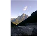
In the southern part of the Upper Pobič, a 2 km long forest maintenance road runs through the valley of the Resàrtico stream, following the bed of the powerful Resàrtico stream with its numerous artificial dams. After a kilometre or so, you leave the road and continue along a winding path through the woods and over numerous boulder-strewn streams. As you enter the beech forest, the slope steepens, so that you follow the keys to the next stream (to the left, a few metres away, a beautiful waterfall with a few pools is hidden behind the boulders), beyond which you reach, in a few steps, the Resartico shelter and the ruins of the former mine buildings.
Continue to the left past the ruins. After about 50 metres of ascent, a path branches off to the right of our route to the nearby entrance of the former mine. From the crossroads, we continue left in the keys on an increasingly steeper slope. Soon we reach the edge of a broken, slightly exposed ravine, where direction signs direct us to the left, while a clearly visible path winds right over the edge.
This is a newer path, following the edge of the gully to a scree rib and then steeply, partly exposed, uphill. To the left turns an old path, which first goes over a jump (Level I), above which it winds in short switchbacks through very steep and exposed grasses to a hanging ladder of a few metres, which is very useful on this slope, especially in the wet. Above it, the slope does not give way at all, so the trees that partly cover the rib are very helpful. Soon we reach a cross path where the newer version of the path described above joins from the right. Both versions are interesting, the newer one is perhaps preferable, but the older one is undoubtedly more ephemeral.
After the junction of the two versions, turn left and follow the sometimes eroded and exemplarily narrow path slightly more steeply uphill. In between, we cross several exposed ravines, where old steel cables hidden in the grass are helpful. Soon the slope widens and we continue briefly through a sparse forest. Higher up, it is replaced by scrub and tall grasses with nettles, betraying that we are on the site of the former mountain pasture Lanis. The track is less visible here in places, but winds in a series of gently sloping, almost horizontal keys. After a few minutes, the tedious search for trail tracks is over, as we soon emerge onto an open grassy slope, which again steepens a little to the nearby Slips saddle (1631 m). At the saddle, the path continues to the left, crossing under the south-western slope of Vogršček down towards the mountains of Ungarina and Confin, and to the right, following the path slightly downhill to avoid the rocky slope of the unnamed southeastern promontory of Lopič (only marked on the map with an elevation of 1858 m; it is easily accessible via the north-western ridge linking it with Lopič). Once around it, go up the steep grasses to the edge of the north-facing precipitous ridge and follow it quite steeply, including small rock ledges in the upper part, to the summit.

Pictures:
 1
1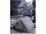 2
2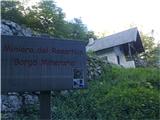 3
3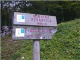 4
4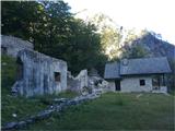 5
5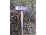 6
6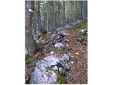 7
7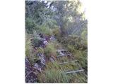 8
8 9
9 10
10 11
11 12
12 13
13 14
14 15
15 16
16
Discussion about the trail Zgornji Pobič / Povici di Sopra - Lopič / Monte Plauris (CAI 702)