Starting point: Planina Krnica (1240 m)
| Lat/Lon: | 46,35274°N 13,50801°E |
| |
Time of walking: 4 h
Difficulty: very difficult pathless terrain
Altitude difference: 1166 m
Altitude difference po putu: 1180 m
Map: Julijske Alpe - zahodni del 1:50.000
Recommended equipment (summer): helmet
Recommended equipment (winter): helmet, ice axe, crampons
Views: 4.230
 | 4 people like this post |
Access to the starting point:
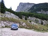
Drive into the centre of Bovec, where from the crossroads by the main square continue along the ascending road, which starts to climb past the post office towards the nearby church. Go around the church on the left and then arrive in Kaninsko vas. Bovec then ends and the road continues westwards for some time. At a small fork, leave the main asphalt road leading to the village Plužna and continue along the road slightly to the right (after the crossroads marked for the Gozdec road). After the nearby homestead, the road splits again, and this time we take the road slightly to the left (slightly to the right Zavrzelno and the starting point of the route to Rombon). We continue to climb on the macadam road, which leads us higher up to the B station of the cable car to Kanin. At the B station, the road turns sharp left, and then, after about 1 km of further driving, a cross-country climb brings us to the next crossroads. At this junction, turn sharp right towards mountain pasture Cirque (Gozdec on the left). Later, the road to stations C and D branches off to the left. We continue straight on until mountain pasture Cirque where there is a small parking lot. The road is in a rather bad condition in the last part towards mountain pasture Cirque.
Path description:
From the parking lot at mountain pasture Cirque turn left onto the marked footpath, which starts to climb and quickly leads into lane of a sparse forest. The forest soon ends and the path continues along mostly grassy terrain, with dwarf pines still growing at first. The path through the valley Cirque turns slowly slightly to the left and then runs north-westwards. Only occasionally a slightly steeper path, but higher up it passes from the grassy slopes to the scree slopes below the slopes of the Lope. The path later climbs a little more and soon leads us to the ski resort at Prevala where there is also a crossroads.
At the Prevala saddle, continue to the right and start climbing up the ski slope towards the upper station of the Italian gondola. Here, first a beautiful view opens up to the west, then to the north where Jôf di Montasio and Viš are visible. As the ski slope turns right, we are joined on the left by route 536 from Nevejski sedlo. There is only a short climb to the top station of the cable car.
At the top station of the gondola, turn left onto an unmarked path that crosses the scree on the northern slopes to the east. The path initially crosses the slopes below the northern face of the Vršiči pod Lopo (Monte Golovec) ridge in a gentle ascent. When you reach the north-western side of the ridge, you can see the Forca sopra Medon to the right. We continue along the path that crosses the slopes to the east. The path continues and occasionally climbs slightly until it reaches a notch on the eastern side of Lopa Peak.
Approximately 10 metres before the notch (the first slightly easier passage from the notch on the north side), turn right up towards the ridge. After an initial very short climb, the terrain flattens out a little and you will see a short gully ahead. There is also some rubble on the slope at this part. Head straight towards the gully. After only a few metres of climbing up the gully, continue left on the ledge.
Once on the ledge, you have two options. After a few metres on the ledge, we can turn right and then climb a few metres to the ridge. If you head right at the right point, the difficulty of the climb does not exceed level 1. Alternatively, you can continue along the ledge to reach the south side of the ridge. On the south side, where the slope is slightly overgrown with grass, continue for a short time on the steep slope below the ridge. When the slope above us becomes a little less steep, turn right onto the ridge.
As you continue along the ridge, the climb becomes less demanding for a while. The cairns are also helpful when walking along the ridge. A little higher up, we come to a steeper slope again. Keep to the left for the initial part of the steep slope and then, about halfway up, cross a steep slope, partly covered with grass, to the right. Some cairns is also helpful for orientation. There is a short steep climb and then we continue to the left and soon reach the ridge again.
Continue walking along the ridge all the way to the summit. There are a few short steep climbs in the last part of the ridge, but they do not present any major problems.
Descend along the ascent route.
For the less experienced, belaying with a rope is recommended on the more difficult parts.

Pictures:
 1
1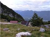 2
2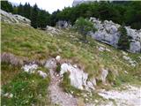 3
3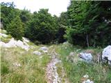 4
4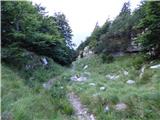 5
5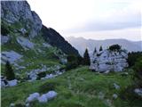 6
6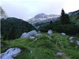 7
7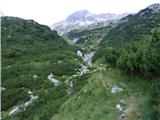 8
8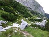 9
9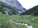 10
10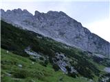 11
11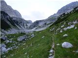 12
12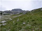 13
13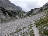 14
14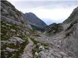 15
15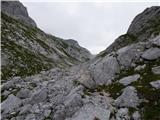 16
16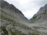 17
17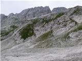 18
18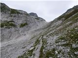 19
19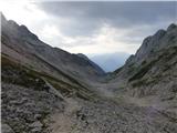 20
20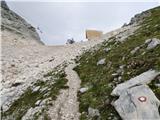 21
21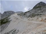 22
22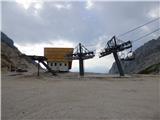 23
23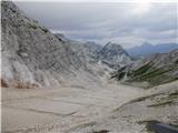 24
24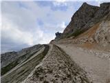 25
25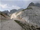 26
26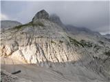 27
27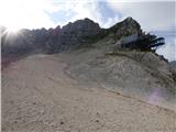 28
28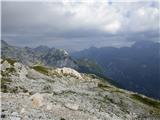 29
29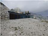 30
30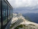 31
31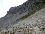 32
32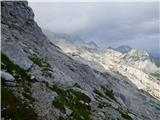 33
33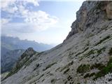 34
34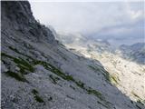 35
35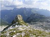 36
36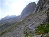 37
37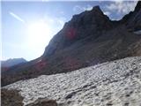 38
38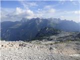 39
39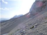 40
40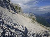 41
41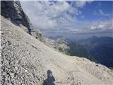 42
42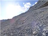 43
43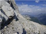 44
44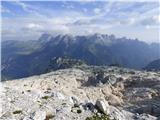 45
45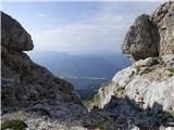 46
46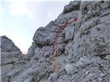 47
47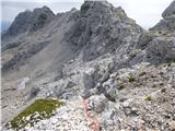 48
48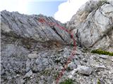 49
49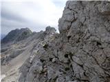 50
50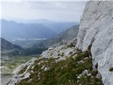 51
51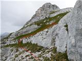 52
52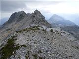 53
53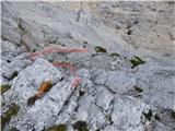 54
54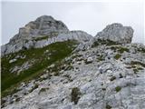 55
55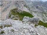 56
56 57
57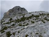 58
58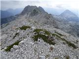 59
59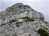 60
60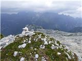 61
61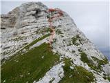 62
62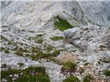 63
63 64
64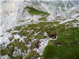 65
65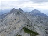 66
66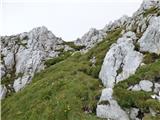 67
67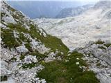 68
68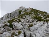 69
69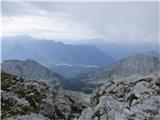 70
70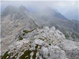 71
71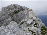 72
72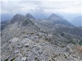 73
73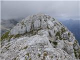 74
74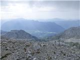 75
75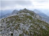 76
76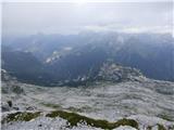 77
77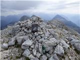 78
78
Discussion about the trail Planina Krnica - Lopa
|
| ljubitelj gora25. 07. 2017 |
Samo opozoril bi, da se avto pusti pri B postaji in peš odpravi, kajti vozit se do Krnice po taki cesti je primerno za terenska vozila.
|
|
|
|
| mirank25. 07. 2017 |
Ni glih tako; do klopce in parkinga, ki se nahaja 400m naprej od odcepa servisne ceste za C postajo se lahko pripelješ z vsakim vozilom. Od tam imaš do Krnice 15min! Preizkušeno zadnjič, ko nam ž. model na žičnici ni hotel prodati karte do B postaje, ker je nima na ceniku  . No, da ne lažem lahko bi kupili komplet:zavijanjezocmi ali pa karto za kolesarje  :
|
|
|
|
| ljubitelj gora25. 07. 2017 |
Da se pripeljat, kaj pa po taki vožnji pravi podvozje vozila. 
|
|
|
|
| gams126. 07. 2017 |
opis je dober, a žal , je avtor pretiraval slikami "pogled nazaj", ker se izgubi smisel in občutek, kako zahteven je vzpon.
|
|
|
|
| dprapr4. 09. 2018 |
Če je že šel vse do Prevale, bi bilo veliko lepše pri sliki 30 po travah pristopiti na greben in po njem do Lope, kot pa po tistih meliščih od zadaj.
|
|
|
|
| darinka42. 09. 2020 |
Po novem je pri B postaji oziroma cesti znak za naprej prepovedano za vsa vozila. Kamot parkiraš pri B postaji.
|
|
|
|
| darinka42. 09. 2020 |
Naprej pa vozijo z džipi tiste , ki se spustijo po zip line. In med spuščanjem so eni bili zelo glasni.
|
|
|
|
| darinka417. 09. 2020 |
Včeraj smo šli s Selle Neveje. Po poti 636. Do odcepa za Prevalo. Nadaljevanje po melišču pod vznožjem Lope. Na vrh , kjer so v pomoč možici in rdeče pike na skalah. Tam je bilo treba pazljivo in previdno. Skoro obvezna je uporaba čelade. Varoval ni. Prosto plezanje. Meni je bil vrh krasen razglednik . Ostalim pa tudi. Sestopili smo po isti poti. Pa nikogar srečali. Občudovali z vrha kar veliko jato mislim da jastrebov , ki so jadrali v zraku. Se spomnim, da so manjši ptiči bili zelo vznemirjeni. Če iščeš samoto je tu zagotovo doma.
|
|
|