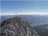
 | Vršič - Jalovec (via Jalovška škrbina)
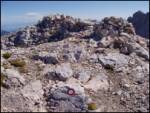
Jalovec is the sixth highest mountain in Slovenia with a height of 2645 m. The summit, which descends steeply towards three Alpine valleys (Loška...
6 h |
| Vršič - Jalovec (via zavetišče pod Špičkom)
Jalovec is the sixth highest mountain in Slovenia with a height of 2645 m. The summit, which descends steeply towards three Alpine valleys (Loška...
6 h 30 min |
 | Vršič - Razor
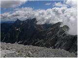
The summit is located above the Alpine valley of Mlinarica. The summit, which is not spacious, has a very nice view. All the peaks above the Kriš...
6 h |
 | Sella Nevea - Visoki Kanin (Via ferrata Rosalba Grasselli)
Visoki Kanin is the highest peak of the Kanin Mountains. From the summit on which the cross stands, you have a beautiful view of the western Juli...
6 h 15 min |
 | Sella Nevea - Visoki Kanin (Via ferrata Divisione Julia)
Visoki Kanin is the highest peak of the Kanin Mountains. From the summit on which the cross stands, you have a beautiful view of the western Juli...
4 h 45 min |
 | Vršič - Prisank / Prisojnik (Jubilejna pot)
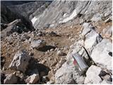
Prisank is a 2547 m high mountain located above the valleys of Mlinarica, Krnica and Suha Pišnica. From the top of the peak, where the registrati...
6 h |
 | Koča na Gozdu - Prisank / Prisojnik (Hanzova pot)
Prisank is a 2547 m high mountain located above the valleys of Mlinarica, Krnica and Suha Pišnica. From the top of the peak, where the registrati...
5 h |
| Erjavčeva koča na Vršiču - Prisank / Prisojnik (via Kajzljeva škrbina)
Prisank is a 2547 m high mountain located above the valleys of Mlinarica, Krnica and Suha Pišnica. From the top of the peak, where the registrati...
5 h |
| Erjavčeva koča na Vršiču - Prisank / Prisojnik (Jubilejna pot)
Prisank is a 2547 m high mountain located above the valleys of Mlinarica, Krnica and Suha Pišnica. From the top of the peak, where the registrati...
6 h 15 min |
| Vršič - Prisank / Prisojnik (via Kajzljeva škrbina)
Prisank is a 2547 m high mountain located above the valleys of Mlinarica, Krnica and Suha Pišnica. From the top of the peak, where the registrati...
4 h 45 min |
 | Aljažev dom v Vratih - Triglavski dom na Kredarici (Tominšek route)
Triglavski dom na Kredarici is Slovenia's highest mountain hut. It is open all year round but only on an emergency basis out of season. From the ...
4 h 50 min |
 | Ravenska Kočna - Dolgi hrbet (past the cableway and on Frischaufova pot)
Dolgi Hrbet is located between Grintovec and Skuta. The precipitous peak offers a beautiful view of the heart of the Kamnik and Savinja Alps. Dol...
5 h |
 | Ravenska Kočna - Dolgi hrbet (umik Žrela and on Frischaufova pot)
Dolgi Hrbet is located between Grintovec and Skuta. The precipitous peak offers a beautiful view of the heart of the Kamnik and Savinja Alps. Dol...
5 h 5 min |
| Ravenska Kočna - Dolgi hrbet (via Štularjeva planina and on path Frischaufova pot)
Dolgi Hrbet is located between Grintovec and Skuta. The precipitous peak offers a beautiful view of the heart of the Kamnik and Savinja Alps. Dol...
5 h |
 | Aljažev dom v Vratih - Begunjski vrh (Tominšek route)
Begunjski vrh is a 2461 m high mountain located in the heart of the highest mountains in the Julian Alps. From the top, which has a registration ...
4 h 50 min |
 | Koča pod slapom Rinka - Kranjska Rinka (via Turski žleb)
Kranjska Rinka is the highest of all Markets. From the top, which has a registration book, you have the best view towards Skuti. The rest of the ...
5 h 5 min |
| Koča pod slapom Rinka - Kranjska Rinka (via Koroška Rinka)
Kranjska Rinka is the highest of all Markets. From the top, which has a registration book, you have the best view towards Skuti. The rest of the ...
5 h 20 min |
| Ravenska Kočna - Kranjska Rinka (Slovenska pot)
Kranjska Rinka is the highest of all Markets. From the top, which has a registration book, you have the best view towards Skuti. The rest of the ...
4 h 35 min |
| Ravenska Kočna - Kranjska Rinka (via Žrelo)
Kranjska Rinka is the highest of all Markets. From the top, which has a registration book, you have the best view towards Skuti. The rest of the ...
4 h 35 min |
| Ravenska Kočna - Kranjska Rinka (hunting path)
Kranjska Rinka is the highest of all Markets. From the top, which has a registration book, you have the best view towards Skuti. The rest of the ...
4 h 50 min |
 | Ruski križ - Pogačnikov dom na Kriških podih (via Kriška stena)
The hut is located on a panoramic hill in the Kriški Podi above Trenta. The hut, which is open in the summer season, also has a large winter room...
5 h 10 min |
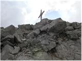
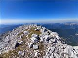
 | Ruski križ - Križ
Križ is a 2140 m high mountain located north-east of the Kriški Podi. From the top, where there is a registration box with a stamp, you have a be...
4 h 45 min |
 | Koča pod slapom Rinka - Koroška Rinka
Koroška Rinka (also Križ) is a 2433 m high mountain rising steeply above Lediny and Okrešlje. From the top, which has a registration box and a st...
5 h |
 | Koča pod slapom Rinka - Koroška Rinka (via Turski žleb)
Koroška Rinka (also Križ) is a 2433 m high mountain rising steeply above Lediny and Okrešlje. From the top, which has a registration box and a st...
5 h |
| Belska Kočna - Koroška Rinka
Koroška Rinka (also Križ) is a 2433 m high mountain rising steeply above Lediny and Okrešlje. From the top, which has a registration box and a st...
4 h 45 min |
| Ravenska Kočna - Koroška Rinka (hunting path)
Koroška Rinka (also Križ) is a 2433 m high mountain rising steeply above Lediny and Okrešlje. From the top, which has a registration box and a st...
4 h 30 min |
 | Koča pod slapom Rinka - Štajerska Rinka (via Turski žleb)
Štajerska Rinka is a 2374 m high mountain rising steeply above Okrešl, more precisely to the east of the more visited Koroška Rinka. From the top...
4 h 45 min |
 | Ravenska Kočna - Štajerska Rinka (Slovenska pot)
Štajerska Rinka is a 2374 m high mountain rising steeply above Okrešl, more precisely to the east of the more visited Koroška Rinka. From the top...
4 h 30 min |
| Ravenska Kočna - Štajerska Rinka (via Žrelo)
Štajerska Rinka is a 2374 m high mountain rising steeply above Okrešl, more precisely to the east of the more visited Koroška Rinka. From the top...
4 h 30 min |
| Ravenska Kočna - Štajerska Rinka (hunting path)
Štajerska Rinka is a 2374 m high mountain rising steeply above Okrešl, more precisely to the east of the more visited Koroška Rinka. From the top...
4 h 45 min |
 | Koča pod slapom Rinka - Turska gora (via Kotliči)
The mountain is located above the Logarska Valley and the Kamniška Bistrica Valley. From the top there is a beautiful view towards the neighbouri...
4 h 30 min |
 | Ravenska Kočna - Mrzla gora (Slovenian way)
This hard-to-reach mountain is located on the border with Austria in the Kamnik and Savinja Alps. From the top you can enjoy a beautiful view of ...
5 h 45 min |
| Koča pod slapom Rinka - Mrzla gora
This hard-to-reach mountain is located on the border with Austria in the Kamnik and Savinja Alps. From the top you can enjoy a beautiful view of ...
4 h 30 min |
| Ravenska Kočna - Mrzla gora (via Žrelo)
This hard-to-reach mountain is located on the border with Austria in the Kamnik and Savinja Alps. From the top you can enjoy a beautiful view of ...
5 h 45 min |
| Ravenska Kočna - Mrzla gora (hunting path)
This hard-to-reach mountain is located on the border with Austria in the Kamnik and Savinja Alps. From the top you can enjoy a beautiful view of ...
6 h |
 | Nassfeld - Creta di Aip / Trogkofel (Uiberlacher Steig)
Creta di Aip is the highest peak in the area of the Mokrine/Nassfeld Pass. The mountain has a sloping summit from which steep precipitous cliffs ...
4 h 30 min |
 | Ski hotel Vogel - Vrh nad Škrbino
Vrh nad Škrbino is the easternmost two-thousandth peak in the ridge of the Lower Bohinj Mountains. From the top there is a very nice view of the ...
4 h 50 min |
 | Reißkofelbad - Reißkofel (via bivouac)
Reißkofel is a 2371 metre high mountain in the Zilj Alps. The summit on which the cross stands also has a registration box. The view from the top...
4 h 30 min |
 | Pecol - Cima di Terrarossa (Leva)
Cima di Terrarossa is a scenic peak located between Jôf di Montasio and Viš. From the summit, which is often full of ibex, you can admire the hig...
4 h 30 min |
 | Sella Nevea - Vrh Krnice
Vrh Krnice is a 2441 m high peak located north-west of Visoki Kanin. From the summit, where the usually empty registration box stands, you can en...
5 h 15 min |
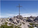
 | Türlwandhütte - Großer Koppenkarstein (via Hunerscharte)
Großer Koppenkarstein is a 2865 metre high mountain in the Dachstein mountain group. It is located above the Schladminger Glacier. From the top w...
4 h 50 min |
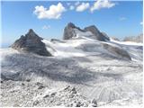 | Türlwandhütte - Kleiner Gjaidstein (via Hunerscharte)
Kleiner Gjaidstein is a 2735 m high peak in the Dachstein mountain group. The peak is located on a ridge between the Schladminger Glacier and the...
4 h 30 min |
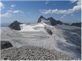 | Türlwandhütte - Hoher Gjaidstein (via Hunerscharte)
Hoher Gjaidstein is a 2,792-metre-high peak in the Dachstein mountain group. The peak is located on a ridge between the Schladminger Glacier and ...
5 h |
 | Ristorante Pietofana - Cima Formenton (via Rifugio Pomedes)
Cima Formenton is a 2830 m high peak in the Tofana mountain group. The mountain is located to the north of the better known Tofana di Dentro, and...
5 h 5 min |
 | Klammbrückl - Weittalspitze (Allmaier Toni Weg)
Weittalspitze is a 2,539-metre-high peak in the Lienz Dolomites. The summit is located south of the mountain pasture Kerschbaumeralm. From the su...
4 h 30 min |
 | Plockenpass - Pilastro del Coglians
Pilastro del Coglians is a 2750 m high peak located east of Monte Coglians on the border between Austria and Itali. There is also a registration ...
4 h 30 min |
 | Rifugio Cercena - Cima Montanel
Cima Montanel is a 2,461-metre-high peak overloking the Piave Valley in the Carnioan Pre-Alps. The summit on which the cross is erected is a rema...
4 h 40 min |
| Rifugio Padova - Cima Montanel (via Forcella di Crodon)
Cima Montanel is a 2,461-metre-high peak overloking the Piave Valley in the Carnioan Pre-Alps. The summit on which the cross is erected is a rema...
4 h 50 min |
 | Plöckenpass - Creta della Chianevate / Kellerspitzen (path 171)
Creta della Chianevate (German: Kellerspitzen) is a 2,769-metre-high peak in the central part of Carnic Alps on the border between Austria and It...
4 h 50 min |
 | Capanna Alpina - Vallon Bianco
Vallon Bianco (Valun Blanch in Ladin) is a 2688 metre high peak above the Valle di Fanes and Val Travenanzes. From the top, where a small cross a...
4 h 20 min |
| Sant'Uberto - Vallon Bianco
Vallon Bianco (Valun Blanch in Ladin) is a 2688 metre high peak above the Valle di Fanes and Val Travenanzes. From the top, where a small cross a...
5 h 5 min |
| Rifugio Pederü - Vallon Bianco
Vallon Bianco (Valun Blanch in Ladin) is a 2688 metre high peak above the Valle di Fanes and Val Travenanzes. From the top, where a small cross a...
4 h 40 min |
 | Capanna Alpina - Furcia Rossa III
Furcia Rossa III is a 2791 m high peak in a slightly more secluded ridge over which the Fridensweg / Via della pace leads. At the top, next to th...
4 h 30 min |
| Rifugio Pederü - Furcia Rossa III
Furcia Rossa III is a 2791 m high peak in a slightly more secluded ridge over which the Fridensweg / Via della pace leads. At the top, next to th...
4 h 50 min |
 | Parkirišče Stupfer v dolini Gaistal - Hohe Munde - western peak (po plezalni poti preko zahodnega grebena)
Hohe Munde is a peak in the Mieming Mountains west of Innsbruck and the home mountain of the town of Telfs, overloked by an imposing rock fortres...
6 h 15 min |
 | Gozdec - Vrh Laške Planje
Vrh Laške Planje (Lasca Plagna) is a 2,448-metre-high peak located on the border ridge between Itali and Slovenia. From the top, you can enjoy a ...
5 h |