Svino - Monte Mataiur/Matajur
Starting point: Svino (250 m)
| Lat/Lon: | 46,2424°N 13,569°E |
| |
Time of walking: 3 h 45 min
Difficulty: easy marked way
Altitude difference: 1392 m
Altitude difference po putu: 1392 m
Map: Julijske Alpe - zahodni del 1:50.000
Recommended equipment (summer):
Recommended equipment (winter): ice axe, crampons
Views: 26.978
 | 3 people like this post |
Access to the starting point:
a) Access from Tolmin: From Tolmin, drive towards Kobarid and take the newly built ring road, which bypasses Kobarid on the right, straight towards the centre. Just before the centre of Kobarid, the road to the village of Svino branches off to the left. The turn-off is marked! Follow this road until it starts to climb. Park in the parking lot on the roadside. If you continue driving to the village of Svino, you have not gained anything as there is no parking there.
b) Access from Bovec: From Bovec drive towards Kobarid and when you get to the bypass past Kobarid turn right into the centre of Kobarid. In the centre of Kobarid, the road to the Robič border crossing turns right. Here continue straight on (slightly left) towards Tolmin but only a few dozen metres to where the road to the village of Svino branches off to the right. Continue as described above.
Path description:
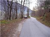
From the parking lot, continue along the road along which you parked. After a good five minute walk you reach the village Svino, where you see the signs for Monte Mataiur to the left and Sužid to the right. Here, continue left between the houses with inconspicuous signs for Monte Mataiur. If you are not sure which way is the right way, it is better to ask someone if you have the opportunity. The right path goes a little further left and soon leads us past the houses and across the pastures after which the path goes into the wods. Further ahead, the markings are more frequent and orientation is easier.
The path then starts to climb steeply and after about half an hour's walk leads us to the wider cart track, which comes from the village of Sužid. The cart track, which has a few switchbacks but is well marked, continues to climb for some time. Before a dilapidated old military bastion, the trail turns left up to Monte Mataiur. Here cart track turns into a steep military mulatier, which takes us up a rather steep slope to less steep slopes. The path then leads us to a newly built forest road which we just cross. On the other side of the road, we climb a few steps and see the shepherd's huts on Svinska mountain pasture in front of us.
On mountain pasture we see the markings mountain pasture Idrsko on the left, mountain pasture Sužid on the right. There are no markers for Monte Mataiur but the route to Monte Mataiur is marked.
The path is found between the huts at mountain pasture and continues along a small unmarked valley moderately uphill. Although the path is marked, it is poorly visible and overgrown in places. After about 15 minutes of walking from mountain pasture you will reach a water tank and near it you will see mountain signs. Here, head straight in the direction of Monte Mataiur along the still poorly visible but marked trail. The trail then leads us across an overgrown meadow behind which we join a beautifully worn path coming from the village Avsa or Livek.
Continue to the right and the path, which climbs moderately, then soon leads us to the next signposts, where we continue left upwards in the direction of Monte Mataiurja. Just a few steps further on, you will reach the border ridge between Slovenia and Itali. Here the path turns right and continues to climb along a wide gently sloping ridge. Follow this path, which leads us through increasingly beautiful views, to the top of Monte Mataiur, which we can already see in front of us. Svino - Svinska planina 2:40, Svinska planina - Monte Mataiur 1:05.

Pictures:
 1
1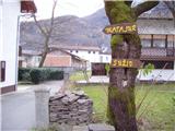 2
2 3
3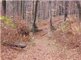 4
4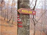 5
5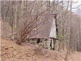 6
6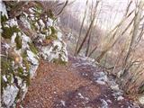 7
7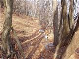 8
8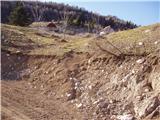 9
9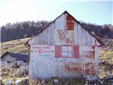 10
10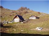 11
11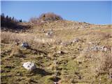 12
12 13
13 14
14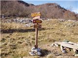 15
15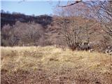 16
16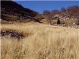 17
17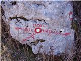 18
18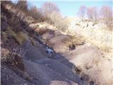 19
19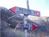 20
20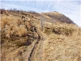 21
21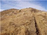 22
22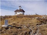 23
23 24
24
Discussion about the trail Svino - Monte Mataiur/Matajur
|
| pier14. 01. 2010 |
V nedeljo nameravam opraviti izlet po tej poti, pa bi prosil, za informacijo o sneznih razmerah in, ce so, tezavnosti pri orientaciji.
Najlepsa hvala
|
|
|
|
| mojcej'723. 08. 2010 |
Včeraj 2.8.2010 sem si izbrala tole verzijo vzpona na Matajur, kot eno izmed točk SLOVENSKE planinske transverzale. Na vrhu pa zgroženo ugotovila, da obstaja le ITALIJANSKA vpisna knjiga, in še ta v neki leseni škatli znotraj cerkvice in popolnjena z vpisi do konca in še na platnicah. O žigu pa ne znotraj, ne zunaj pri razgledni kamniti točki, ne duha ne sluha, tudi plehnata skrinjica je bila prazna. Ali je PD Gorica malo na počitnicah?, ali pa ne vemo več čigav je Matajur - slovenski ali italijanski. In kje je slovenska vpisna knjiga? Na drugi strani v Domu pod Matajurjem (prelaz Pelizzo) sicer v koči imajo žig - trikoten - ampak ne vem če velja za našo transverzalo. Poleg tega na njem piše MONTE NERO, kar bi v prevodu bilo Črni vrh. To pa je tudi naslednji vrh proti zahodu, če se greš italijansko vezijo pohodov. Dočim pa je na kartah Črni vrh vpisan pod italijansko verzijo MONTE FUSCO. Fino bi bilo, če bi bili vrhovi, žigi in karte na mejnih področjih usklajeni. No ja, dan je bil vseeno lep.
|
|
|
|
| mojcej'723. 08. 2010 |
Včeraj 2.8.2010 sem si izbrala verzijo vzpona na Matajur iz vasice Svino. Na vrhu Matajurja kot točke SLOVENSKE transverzale pa zgroženo ugotovila, da obstaja le ITALIJANSKA vpisna knjiga (v leseni škatli znotraj cerkvice) in še ta popolnjena z vpisi do konca in še na platnicah. O žigu pa ne znotraj, ne zunaj pri razgledni kamniti točki, ne duha ne sluha, tudi plehnata skrinjica je bila prazna. Ali je PD Gorica malo na počitnicah?, ali pa ne vemo več čigav je Matajur - slovenski ali italijanski. In kje je slovenska vpisna knjiga? Na drugi strani v Domu pod Matajurjem (prelaz Pelizzo) sicer imajo žig - edini - je pa enakokrat trikoten in na njem piše MONTE NERO (Črni vrh), Rifuggio Pelizzo. Zdaj pa ne vem, kdo je bolj smotan, mi ali oni. Črni vrh je namreč vrh, ki leži še bolj zahodno in je na slovenskih kartah označen kot Črni vrh s prevodom Monte Nero, na italijanskih kartah pa kot Monte Fusco in spodaj s slovenskim prevodom Črni vrh. Fino bi bilo, če bi uskladili vrhove z žigi (PZS)in kartami na mejnih področjih tudi z Geodetskim zavodom. No, tudi brez tega je bil sicer dan lep.
|
|
|
|
| mojcej'723. 08. 2010 |
Ja potem so ga pa ukradli, kaj jaz vem, zdaj ga ni bilo.
|
|
|
|
| klm7. 02. 2013 |
Žig je že 3. 7. 2012 odnesla kavka. Sicer pa zgolj pripomba k zgornjemu opisu: med potjo ne obidemo "propadajoče stare vojaške bajte" še posebej ne vojaške, pač pa propadajoči senik, kakršni so razmetani okrog in okrog Matajurja in gre za tipični arhitekturni tip stavbe, ki je služila za spravilo sena na senožetih. Te se bile še najbolj v uporabi med 50. in poznimi 70. leti prejšnjega stoletja, nakar so se začele postopoma zaraščati.
|
|
|
|
| Skovik8. 10. 2014 |
A je al ni žig na vrhu sedaj?
|
|
|
|
| slavkoo8. 10. 2014 |
Žig na vrhu JE. Tisti "ta železni", je treba imeti s seboj blazinico. Blizu razgledne kamnite točke, treba dobro pogledat, na neki cevi je...
|
|
|
|
| Skovik9. 10. 2014 |
Super, hvala za odgovor 
|
|
|