Zell-Schaida - Hochobir (Ojstrc)
Starting point: Zell-Schaida (1069 m)
| Lat/Lon: | 46,4791°N 14,4675°E |
| |
Time of walking: 3 h
Difficulty: easy marked way
Altitude difference: 1070 m
Altitude difference po putu: 1070 m
Map: Karavanke - osrednji del 1:50.000
Recommended equipment (summer):
Recommended equipment (winter): ice axe, crampons
Views: 23.644
 | 2 people like this post |
Access to the starting point:
a1) From the motorway Ljubljana - Jesenice take the exit Ljubelj (Tržič) and then continue driving towards Klagenfurt / Klagenfurt. After the Ljubelj tunnel, the road starts to descend and we follow it to a crossroads where the road to Borovlje / Ferlach branches off slightly to the right and downwards. The road continues to descend and quickly leads to the aforementioned place, where we soon cross the railway line. Just after the railway line, we join another road, which we follow to the right, and we follow it in the direction of Sele pri Cerkvi / Zell - Pfarre. The road then begins to climb towards the above-mentioned settlement, which is situated at about 950 m above sea level. It then descends gradually to the settlement of Sele - Borovnica / Zell - Freibach and to a crossroads where the road joins the road past the Borovnica dam lake (description a2). Here we continue to the right towards Sele - Schajda / Zell - Schaida and Železna Kapli / Bad Eisenkappel. Follow the road to Železna Kapla only as far as the Schajda / Schaidasattel Alpine Pass, where you park in a well maintained asphalt parking lot. From the tunnel entrance to the starting point is about 33 km
a2) From the motorway Ljubljana - Jesenice take the exit Ljubelj (Tržič) and then continue driving towards Klagenfurt / Klagenfurt. After the Ljubelj tunnel, the road starts to descend and we follow it to a crossroads where the road to Borovlje / Ferlach branches slightly to the right and downwards. The road continues to descend and quickly leads us to the aforementioned place, where we soon cross the railway line. Just after the railway line, we join another road, which we follow to the left (right Sele near Cerkva / Zell - Pfarre (description a1)) and then right at the next slightly larger junction. At the end of Borovlje you reach a roundabout, from which you continue again in the direction of Železna Kaple. Continue driving through the villages of Medborovnica / Unterferlach, Ostrovca / Ostrouza, Trata / Tratten, Glinje / Glainach, Vesca / Dörfl, Ždovlje / Seidolach, Dobrova / Dobrowa, Kočuha / Gotschuchen, Šmarjeta v Rož / Sankt Margareten and Rosental, Dolnja vas / Niederdörfl to the village of Zgornja Vesca / Oberdörfl. Just after the last mentioned village, you will reach a slightly larger crossroads, where you will turn right towards Sele / Zell (Pri Cerkvi / Zell - Pfarre, Borovnica / Freibach and Šajda / Schaida). Continue past the Borovnica dam / Freibach - Stausee, after which the road becomes slightly narrower, and then quickly reaches a point where you join the road from Sele pri Cerkvi (description a1). Here we continue to the left towards Sele - Schajda / Zell - Schaida and Železna Kapli / Bad Eisenkappel. Follow the road to Železna Kapla only as far as the Schajda / Schaidasattel Alpine Pass, where you park in a well maintained asphalt parking lot. From the tunnel entrance to the starting point is about 38. 5 kmb) Via Border crossing Jezerski vrh or Pavličev vrh, drive into Austria and continue to Železna Kapla / Bad Eisenkappel. In Železna Kapla, leave the main road and continue driving to the left in the direction of Obirsko / Ebriach and Sele - Šajda / Zell Schaida. After a few kilometres, we reach a crossroads where the road to Korte / Trögern branches off to the left, and we continue straight ahead and follow the ascending road to the Schaidasattel / Schajda Pass, where we park in the parking lot on the left-hand side of the road. From Border crossing Jezerski vrh to the starting point is just over 28 km and from Border crossing Pavličev vrh about 30 km.
c) First drive to Dravograd, then continue to Border crossing Vič and Labot / Lavamünd in Austria. In the aforementioned town, turn left and then drive towards Pliberk / Bleiburg and Železna Kapla / Bad Eisenkappel. In Železna Kapla turn right towards Obirsko / Ebriach and Sele - Schajda / Zell Schaida. After a few kilometres, we reach a crossroads where the road to Korte / Trögern branches off to the left, and we continue straight ahead and follow the ascending road to the Schaidasattel / Schajda Pass, where we park in the parking lot on the left-hand side of the road. From Border crossing Vič to the starting point is just over 64 km.
Path description:
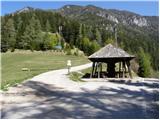
From the parking lot, walk to the nearby pass, and from there continue right towards the Hochobir peak (Hochobir is the highest peak of the Obir). The route takes you past a pleasant rest area at the very beginning, and then along a dirt road, which opens up a beautiful view of the northern walls of the Košuta, Freiberg / Freiberg and beyond. Follow the dirt road from the main road at the Šajda Pass to signposts pointing to the right onto a path that begins to climb through the forest. The trail, which crosses the macadam road 8 times, climbs through the forest most of the time, but in between there are enough clearings, grassy slopes and sparse forest to give us a nice view, especially to the south and west. When you finally leave the road, climb the wooden steps and then emerge from the forest into a larger meadow, where you will see Kacmun's Cross on the right.
At Kacmun's Cross, the path first turns left and leads past the entrance to the tunnel. After the tunnel, the steep path continues straight on to Kravji vrh (across the meadow, a trackless path), and we continue on the marked path, which turns right into the forest. After a few minutes, the mostly spruce forest begins to thin out, and then the path leads us over a pasture fence to a view of the increasingly grassy slopes. The path continues along an undistinguished grassy valley towards Obirsattel. A few steps before reaching the saddle, the marked path turns right (and the unmarked path to Kravji vrh branches off to the left).
Continue climbing gently to moderately along the top slope of Obir, from where you can enjoy beautiful views. A little further on, the path completely flattens out and passes the ruins of the former Rainer's shelter / Rainer Schutzhaus on the left. A little further on, the path joins the path from the Kapel hut / Eisenkappler Hütte. Continue straight ahead and climb up to the 2139 m high summit along the ridge, which is increasingly visible and, especially in the snow, dangerous to slip on.

Pictures:
 1
1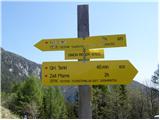 2
2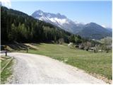 3
3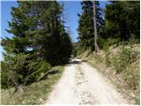 4
4 5
5 6
6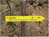 7
7 8
8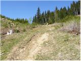 9
9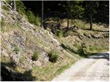 10
10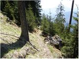 11
11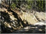 12
12 13
13 14
14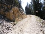 15
15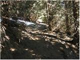 16
16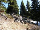 17
17 18
18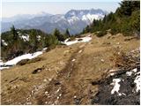 19
19 20
20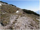 21
21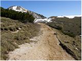 22
22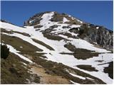 23
23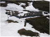 24
24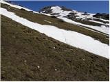 25
25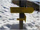 26
26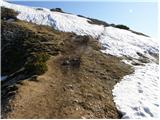 27
27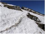 28
28 29
29
Discussion about the trail Zell-Schaida - Hochobir (Ojstrc)
|
| izigov5. 10. 2009 |
Včerajšnji pohod.
Vreme bilo super z vetrom na vrhu.
Lp s Koroške
|
|
|
|
| aonuk16. 10. 2009 |
Odkod pa toliko snega na vrhu ?
|
|
|
|
| izigov6. 10. 2009 |
To so stare slike - snega sedaj ni bilo.  Lp s Koroške
|
|
|
|
| izigov6. 10. 2009 |
Na zgornjem linku so sveže slike od nedelje..
|
|
|
|
| kolosej1. 11. 2011 |
Ob opisani poti na Ojstrc se za zbiralce dvatisočakov nahaja Kravji vrh - 2017m, ki je sicer na zemljevidu PZS Karavanke 1:50000 označen z 2024m. Vrh je v celoti poraščen z rušjem, tako da je potrebno poiskati prehod v Z delu grebena, sledimo labirintu izsekanega rušja, ki nas lahkotno pripelje do vrha, kjer je lep križ z dvojezičnim napisom in vpisna skrinjica.
|
|
|
|
| kitina21. 05. 2012 |
V soboto sem bil gor.Lepa pot z lepimi razgledi.Vreme sonco z nekaj vetra.Lp.
|
|
|
|
| malovrh48. 07. 2012 |
Včerja sem opravil vzpon po opisani poti. Čudovito. Skoraj do vrha nisem srečal nikogar, na vrhu pa več kot 50 planincev. Dodal bi samo še to, da je dostop do izhodišča iz osrednje Slovenije bistevno hitrejši preko Ljubelja kot pa Jezerskega (za več kot 40 min)
lp
|
|
|
|
| PAJKEC30. 10. 2013 |
Osvojil vrh v soboto. Krasna tura, zelo lepo speljana pot, nenaporna in z čudivitimi razgledi.Glede dostopa do Šajde bi se strinjal s prehodnikom, da je najbližje čez Ljubelj, vendar bi dodal, da je še bližje, če se v Borovljah držimo desno za Zell-Pfarre, ker zgoraj opisana pot gre precej okoli.Lahko pa naredimo krog in si ogledamo še lepo dolino Podjuno ter Borovniško jezero.
|
|
|
|
| zajko4. 08. 2014 |
Včeraj iz Šajde na Obir,nazaj pa po grebenu (zelo lepa razgledna pot) na Kravji vrh in spust v dolino.Spust do priključka na markirano pot je zelo strma.Sicer pa zelo lep izlet.Kar zadeva vožnje z avtom,pa je enaka dolžina čez Ljubelj ali čez Jezersko.
|
|
|
|
| ljubitelj gora11. 11. 2018 |
Po tej opisani poti na vrh Obirja, nekaj podrtih dreves na pohodni poti, drugače pa vredu pot je lahka.
|
|
|
|
| michael6616. 08. 2019 |
A mogoče kdo ve,kako bi se s poti iz sedla Šajda na Obir,dalo najlažje mimogrede obiskati še Kravji vrh? 
|
|
|
|
| sh16. 08. 2019 |
Pred časom smo prehodili omenjeno pot, najprej s Šajde na vrh Obirja in ob povratku čez Kravji vrh. Pot je lepo vidna.
|
|
|
|
| J.P.9. 10. 2022 16:25:48 |
Vožnja z avtom je casovno krajsa cez Ljubelj saj zajame vecji kos avtoceste.(ce greste iz Lj npr.) Ojstrc, Kravji vrh in no name vrh umes (morda pa ima ime?!) so izjemno razgledni vrhovi. Eni izmed lepsih. Ojstrc drugace, obljuden vendar ne iz smeri Šajde. Toplo priporočam.
|
|
|