 | Poljana (Završnica) - Hochstuhl/Stol (Žirovniška pot)
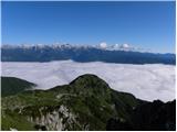
At 2236 m, Stol is the highest peak in the Karavanke Mountains. From the summit, which has a registration box and a stamp, we have a beautiful vi...
4 h 20 min |
 | Poljana (Završnica) - Hochstuhl/Stol (Zabreška pot)
At 2236 m, Stol is the highest peak in the Karavanke Mountains. From the summit, which has a registration box and a stamp, we have a beautiful vi...
4 h 40 min |
 | Zalog - Storžič (below Psica and through southwest groove)
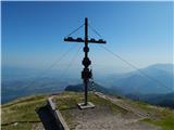
Storžič is a 2132 m high mountain located in the western part of the Kamink Savinja Alps. From the top with a cross there are beautiful views of ...
4 h 35 min |
| Zalog - Storžič (via Planina Javornik and through southwest groove)
Storžič is a 2132 m high mountain located in the western part of the Kamink Savinja Alps. From the top with a cross there are beautiful views of ...
4 h 30 min |
 | Polje - Črna prst
On the northern slope of the Črna prst summit head, you can see the black soil from which the mountain takes its name. Črna prst is known for its...
3 h 45 min |
 | Polje - Črna prst (via Orožnova koča)
On the northern slope of the Črna prst summit head, you can see the black soil from which the mountain takes its name. Črna prst is known for its...
4 h |
 | Podbrdo - Črna prst (via Vrh Bače)
On the northern slope of the Črna prst summit head, you can see the black soil from which the mountain takes its name. Črna prst is known for its...
5 h 25 min |
 | Bohinjska Bistrica - Črna prst (via Orožnova koča)
On the northern slope of the Črna prst summit head, you can see the black soil from which the mountain takes its name. Črna prst is known for its...
3 h 40 min |
| Bohinjska Bistrica - Črna prst (via Planina za Črno goro)
On the northern slope of the Črna prst summit head, you can see the black soil from which the mountain takes its name. Črna prst is known for its...
4 h |
 | Golnik - Tolsti vrh (via Kriška goro)
Tolsti vrh, located to the west of Storžič, is also the highest peak of the Kriška Gora, a mountain range rising steeply above the central Gorenj...
3 h 30 min |
 | Križe - Tolsti vrh (steep path over Kriška gora)
Tolsti vrh, located to the west of Storžič, is also the highest peak of the Kriška Gora, a mountain range rising steeply above the central Gorenj...
3 h 30 min |
| Križe - Tolsti vrh (easier path over Kriška gora)
Tolsti vrh, located to the west of Storžič, is also the highest peak of the Kriška Gora, a mountain range rising steeply above the central Gorenj...
3 h 45 min |
 | Križe - Tolsti vrh (via Ježa)
Tolsti vrh, located to the west of Storžič, is also the highest peak of the Kriška Gora, a mountain range rising steeply above the central Gorenj...
3 h 30 min |
 | Luče - Velika Raduha
At 2062 m, Velika Raduha is the highest peak of Raduha, a mountain range rising steeply to the east of Robanov Kot. From the summit, which has a ...
4 h 40 min |
 | Drežnica - Krn (south way)
At 2244 m, Krn is the highest peak of the Krn Mountains, a mountain range that rises steeply above the central part of the Soča River. From the s...
5 h |
 | Trenta - Zasavska koča na Prehodavcih
Zasavska koča na Prehodavcih is located on a scenic peak above the Triglav Lakes Valley. The hut, which is open in the summer season, offers a be...
4 h 15 min |
 | Mače - Srednji vrh (via Kozjek and Dolga njiva)
Srednji vrh is an 1853 m high mountain located to the east of Storžič. From the top, where there is a bench, a registration box and a stamp, we h...
3 h 30 min |
| Spodnja Kokra - Srednji vrh
Srednji vrh is an 1853 m high mountain located to the east of Storžič. From the top, where there is a bench, a registration box and a stamp, we h...
4 h |
| Mače - Srednji vrh (Mačenska pot and via Cjanovca)
Srednji vrh is an 1853 m high mountain located to the east of Storžič. From the top, where there is a bench, a registration box and a stamp, we h...
3 h 50 min |
| Mače - Srednji vrh (Mačenska pot and via Dolga njiva)
Srednji vrh is an 1853 m high mountain located to the east of Storžič. From the top, where there is a bench, a registration box and a stamp, we h...
3 h 35 min |
| Mače - Srednji vrh (via Kozjek and Cjanovca)
Srednji vrh is an 1853 m high mountain located to the east of Storžič. From the top, where there is a bench, a registration box and a stamp, we h...
4 h |
 | Spodnja Kokra - Bašeljski vrh
Bašeljski vrh is a 1744 m high mountain located between Mali Grintovec and Storžič. From the top, where there is a bench and a registration box w...
5 h |
 | Kraljev hrib - Konj
Konj is a 1803 m high peak located between Velika planina and Presedlje. From the top, we have a beautiful view of the highest peaks of Kamnik Sa...
3 h 30 min |
 | Poljana (Završnica) - Prešernova koča na Stolu (Žirovniška pot)
Prešernova koča na Stolu, is located just a few metres below the summit of the 2198 m high Mali Stol. From the hut or the nearby Mali Stol, we ha...
4 h 5 min |
 | Poljana (Završnica) - Prešernova koča na Stolu (Zabreška pot)
Prešernova koča na Stolu, is located just a few metres below the summit of the 2198 m high Mali Stol. From the hut or the nearby Mali Stol, we ha...
4 h 25 min |
 | Ribčev Laz - Rodica (via Čez Suho)
The mountain is located above Bohinj in the Lower Bohinj Mountains. From the top there is a beautiful view of Julian Alps and Škofjeloško and the...
4 h 15 min |
 | Mače - Mali Grintovec (via Bašeljski vrh)
Mali Grintovec is a lookout mountain located to the east of Storžiča. From the top, where there is a registration box, a stamp and a nice bench, ...
4 h |
| Mače - Mali Grintovec (via Kozjek and Dolga njiva)
Mali Grintovec is a lookout mountain located to the east of Storžiča. From the top, where there is a registration box, a stamp and a nice bench, ...
3 h 30 min |
| Mače - Mali Grintovec (Mačenska pot and via Dolga njiva)
Mali Grintovec is a lookout mountain located to the east of Storžiča. From the top, where there is a registration box, a stamp and a nice bench, ...
3 h 30 min |
| Bašelj - Mali Grintovec (via Bašeljski vrh)
Mali Grintovec is a lookout mountain located to the east of Storžiča. From the top, where there is a registration box, a stamp and a nice bench, ...
4 h |
| Bašelj - Mali Grintovec (via hospital Košuta and over Bašeljski vrh)
Mali Grintovec is a lookout mountain located to the east of Storžiča. From the top, where there is a registration box, a stamp and a nice bench, ...
4 h 10 min |
| Spodnja Kokra - Mali Grintovec
Mali Grintovec is a lookout mountain located to the east of Storžiča. From the top, where there is a registration box, a stamp and a nice bench, ...
4 h 35 min |
 | Mače - Mali Grintovec (via Dom na Kališču)
Mali Grintovec is a lookout mountain located to the east of Storžiča. From the top, where there is a registration box, a stamp and a nice bench, ...
3 h 45 min |
| Bašelj - Mali Grintovec (via Dom na Kališču)
Mali Grintovec is a lookout mountain located to the east of Storžiča. From the top, where there is a registration box, a stamp and a nice bench, ...
3 h 45 min |
| Bašelj - Mali Grintovec (via hospital Košuta and Dom na Kališču)
Mali Grintovec is a lookout mountain located to the east of Storžiča. From the top, where there is a registration box, a stamp and a nice bench, ...
3 h 55 min |
 | Rosenbach - Rosenkogel/Hruški vrh (via Koprivnjak)
Rosenkogel is a 1776 m high mountain located between Frauenkogel and the slightly less known Klek. From the top, where there is a small chapel de...
4 h |
 | Planina Polog - Batognica (via planina Sleme)
Batognica is a 2164 m high mountain, which was affected by the Mine War during World War I. Remnants of the mine war between the Italians and the...
5 h 45 min |
| Planina Polog - Batognica (via Prehodci)
Batognica is a 2164 m high mountain, which was affected by the Mine War during World War I. Remnants of the mine war between the Italians and the...
6 h |
 | Trdnjava Kluže - Rombon
Rombon is a lookout mountain above Bovec. It is known for being the mountain with the most man-made tunnels in Slovenia. During the First World W...
5 h |
 | Ukanc - Šija (via planina Zadnji Vogel)
The peak is located above the Vogel ski slope in the Lower Bohinj Mountains. From the top there is a beautiful view of the neighbouring peaks in ...
4 h 25 min |
 | Ukanc - Šija (via Žagarjev graben)
The peak is located above the Vogel ski slope in the Lower Bohinj Mountains. From the top there is a beautiful view of the neighbouring peaks in ...
4 h |
 | Poljana (Završnica) - Potoški Stol (Žirovniška pot)
Potoški Stol is located between Hochstuhl and Weinasch on the border with Austria. Just a few metres below the grassy peak, a cross is erected. T...
4 h 25 min |
 | Spodnja Kokra - Cjanovca
Cjanovca is the peak east of Storžič and south of Sredni vrh. It is a peak that can be seen from Kranj and the surrounding area. The southern slo...
3 h 45 min |
| Mače - Cjanovca (Mačenska pot and on SE ridge)
Cjanovca is the peak east of Storžič and south of Sredni vrh. It is a peak that can be seen from Kranj and the surrounding area. The southern slo...
3 h 35 min |
| Mače - Cjanovca (over Kozjek and on SE ridge)
Cjanovca is the peak east of Storžič and south of Sredni vrh. It is a peak that can be seen from Kranj and the surrounding area. The southern slo...
3 h 45 min |
| Mače - Cjanovca (Mačenska pot and via Dolga njiva)
Cjanovca is the peak east of Storžič and south of Sredni vrh. It is a peak that can be seen from Kranj and the surrounding area. The southern slo...
3 h 30 min |
 | Zauchen - Hochobir (Ojstrc) (via Kunetov graben)
Hochobir (Hochobir) is the highest peak of a small mountain range called Obir. It is located west of Železna Kapla (Eisenkappel) on the Austrian ...
5 h 5 min |
 | Podkanja vas / Wildenstein - Hochobir (Ojstrc)
Hochobir (Hochobir) is the highest peak of a small mountain range called Obir. It is located west of Železna Kapla (Eisenkappel) on the Austrian ...
5 h |
 | Ukanc - Vogel (via planina Zadnji Vogel)
When you hear the name Vogel, many people first think of the Vogel ski resort, which is located near the peak of the same name. From the north si...
4 h 30 min |
 | Ukanc - Vogel (via Globoko)
When you hear the name Vogel, many people first think of the Vogel ski resort, which is located near the peak of the same name. From the north si...
4 h 15 min |
 | Waidisch / Bajdiše - Ferlacher Horn / Grlovec
Ferlacher Horn is a mountain with a large cross on top. From the top, you have a beautiful view of Karawanks, part of the Julian and Carnic Alps....
3 h 35 min |
 | Glavaš - Dinara (mimo Martinove Košare in po zahodni poti)
At 1831m, Sinjal Peak or Dinara is the highest peak in Croatia. From the top, where there is a signing box and a cross, there is a beautiful view...
4 h 30 min |
| Glavaš - Dinara (mimo zavetišča Drago Grubać)
At 1831m, Sinjal Peak or Dinara is the highest peak in Croatia. From the top, where there is a signing box and a cross, there is a beautiful view...
4 h |
 | Globasnitz - Wackendorfer Spitze
Wackendorfer Spitze is the northernmost two-thousander in the Pec mountain range. From this inconspicuous peak, in fine weather, we can enjoy a m...
4 h 45 min |
 | Globasnitz - Feistritzer Spitze
Feistritzer Spitze is a 2113 m high peak located on the Austrian side of Pec. From the top on which the cross stands, you have a beautiful view o...
5 h |
 | Globasnitz - Končnikov vrh
Končnikov vrh is a 2109 m high mountain located in the central part of Pec. The grassy peak offers a beautiful view along the Pec ridge and the m...
5 h 45 min |
 | Podkanja vas / Wildenstein - Kraguljše
Kraguljše are a 1828 m high peak located in the Obir mountain range. From the spacious summit, on which there is a small wooden bench, we have a ...
4 h 10 min |
 | Ukanc - Visoki Orlov rob (via Žagarjev graben)
Visoki Orlov rob is an 1800 m high peak located in the immediate vicinity of the upper station of the single-seater Šija. The summit, located sli...
3 h 45 min |