Bučan - Veliki vrh (Košuta)
Starting point: Bučan (1010 m)
| Lat/Lon: | 46,4463°N 14,2564°E |
| |
Time of walking: 3 h 50 min
Difficulty: very difficult marked way
Altitude difference: 1078 m
Altitude difference po putu: 1180 m
Map: Karavanke - osrednji del 1:50.000
Recommended equipment (summer): helmet, self belay set
Recommended equipment (winter): helmet, self belay set, ice axe, crampons
Views: 3.090
 | 2 people like this post |
Access to the starting point:
From the motorway Ljubljana - Jesenice take the exit Ljubelj (Tržič) and then continue in the direction of Klagenfurt / Klagenfurt. After the Ljubelj tunnel, the road starts to descend, and we follow it on the Austrian side until the first left turn, where the old Ljubelj road branches off to the right. Park at a suitable place at the junction, or higher up on the Austrian side of the Ljubelj border crossing.
Path description:
From the starting point, take the Old Ljubljana Road, which is closed to public traffic with a traffic sign. The road first climbs moderately over two serpentines and then continues along a stream to the ruins of the former church of St Lenart, next to which stands a slightly larger sign. Here the road turns left and gradually moves away from the valley. The road then opens up to beautiful views of Selenitza and other surrounding peaks. The road continues past a small crossroads, where we take a sharp right along the "main" road, and then cross steep slopes at a moderate incline (risk of falling rocks, or in winter avalanche and slipping). Higher up the road makes a few more serpentines, and then leads us to a marked crossroads.
From the crossroads, continue left towards the marked path to Loibler Baba / Loibler Baba (straight ahead Koča na Ljubelju for about 10 minutes) and continue on the less well marked road. The marked trail soon turns right off the road and climbs steeply at first. The path soon levels out and turns left. There is a cross-climb to the left, on a path that is usually quite slippery. After a few minutes of cross-climbing, the path leads to the border ridge, where it climbs gently to moderately at first, and then climbs quite steeply for a while higher up. During the steep climb, looking back, we get a nice view towards Stolo, Vertatscha, Palco. . . , and the steep path leads us to a metal ladder, where we climb steeply using fixed safety gear. Above the ladder, there are a few more ropes, then the path is laid and the difficult part via the Brown Ovens is behind us. A little further on, we cross a grazing fence, and then the path leads us along the grassy slopes of Grunt. With beautiful views of Lokovnikov Grintovec, Loibler Baba (Ljubeljska Baba), Veliki vrh in the ridge of Košuta and other surrounding mountains, we soon arrive at a marked crossroads, where we continue to the right in the direction of mountain pasture Korošica and Hajnževo sedlo (straight ahead Loibler Baba, slightly to the left Lokovnikov Grintovec).
The path ahead leads along cart track, which descends gently, crossing a few small wells in the process. A little lower down, the hunting trail from the concentration camp Ljubelj joins us from the right, and we continue straight on and within a few minutes of further walking we arrive at mountain pasture Korošica, where on the right-hand side, on a small rise, we see a pasture. Follow the mountain pasture Korošica signs for Hajnževo sedlo, Veliki vrh and Kofce, along the path which leads into the forest with mountain pasture. Continue through the forest, crossing to the right, and the path leads past a wooden trough, after which you will come out onto a grassy slope with a view. On the other side of the meadow, the forest is gradually replaced by dwarf pines, and we only occasionally follow a slightly steeper path to Hajnževo sedlo, which offers a fine view towards Austria.
From the saddle, continue to the right, where you continue along the view ridge for a short time, and then enter the climbing part of the route, where the route starts to climb steeply with the help of fixed safety gear. The technically difficult part is particularly dangerous for slipping in wet conditions, and the path from the saddle onwards is exposed to falling rocks. Higher up, the fixed safety gear ends, and the route leaves the wall onto steep slopes, over which you then climb to Veliki vrh, with increasingly fine views.
Bučan - mountain pasture Korošica 2:15, mountain pasture Korošica - Hajnževo sedlo 30 minutes, Hajnževo sedlo - Veliki vrh 1:05.

Pictures:
 1
1 2
2 3
3 4
4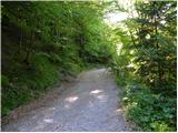 5
5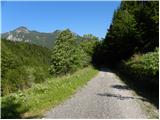 6
6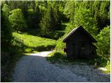 7
7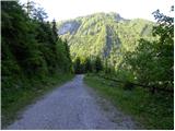 8
8 9
9 10
10 11
11 12
12 13
13 14
14 15
15 16
16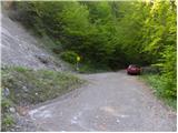 17
17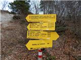 18
18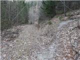 19
19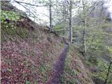 20
20 21
21 22
22 23
23 24
24 25
25 26
26 27
27 28
28 29
29 30
30 31
31 32
32 33
33 34
34 35
35 36
36 37
37 38
38 39
39 40
40 41
41 42
42 43
43 44
44 45
45 46
46 47
47 48
48 49
49 50
50 51
51 52
52 53
53 54
54 55
55 56
56 57
57 58
58 59
59 60
60 61
61 62
62 63
63 64
64 65
65 66
66 67
67 68
68 69
69 70
70 71
71 72
72 73
73 74
74 75
75 76
76 77
77 78
78 79
79 80
80 81
81 82
82 83
83 84
84 85
85 86
86 87
87 88
88
Discussion about the trail Bučan - Veliki vrh (Košuta)