Dolina Ropojana - Maja Jezercë
Starting point: Dolina Ropojana (1150 m)
Time of walking: 6 h 30 min
Difficulty: very difficult marked way
Altitude difference: 1544 m
Altitude difference po putu: 1544 m
Map:
Recommended equipment (summer): helmet
Recommended equipment (winter): helmet, ice axe, crampons
Views: 4.420
 | 3 people like this post |
Access to the starting point:
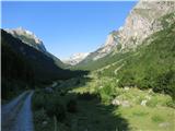
In the centre of Gusinje (Montenegro), follow the sign for Alipaša Springs. After a kilometre, shortly after crossing a bridge, turn left towards the village of Vusanje (Alipaša Springs on the right). Follow the main asphalt road to the end of the village where the road becomes dirt (before the dirt road, there is a waterfall on the right called Grlja). The dirt road, which is in poor condition in some places, leads you through the valley of Ropojan. Along the way (marked with a sign) is the Skakavica Spring, which is worth a stop. Park on the flat part of the valley, about 3 km from the start of the macadam road. If the road is in bad condition, park earlier, which will lengthen the route.
Path description:
From the parking lot, continue along the dirt road, which soon turns into a torrent. Follow the markings, which partly shorten the path across the meadow. Follow the stream to a signpost where the path to the Albanian village of Theth branches off to the right (6h walk), and we continue left along the main cart track, which soon turns sharp left and begins to climb. There are no markings on this part. Soon the path to Theth (unmarked) branches off to the right again, and we continue straight ahead along cart track, which leads us in about half an hour to Karavle Zastan. In summer this is a shepherd's hut where you can refresh yourself with homemade bread and sheep's cheese, and drinks are also available. It is possible to pitch a tent at the caravle and, in case of bad weather, you can sleep inside. At the caravan, continue straight ahead towards the forest, where you will see the markings again. Soon we come to a drinking water spring, and further on to a crossroads where the path for Maja Rosit (4h) branches off to the left, we continue to the right in the direction of Maja Jezercë. The path climbs quite steeply through the forest. As you exit the forest, the path becomes more level and more scenic. Soon we reach a destroyed border stone and enter Albania. It is then that we see the first lakes in the valley of lakes - Buni i Jezercës. The route is mainly on grassy terrain between glacial lakes, which also dry up in summer. The last lake, the so-called Big Lake, is bypassed on the right, on the slope of Maja Bojs. The path, from which there is a fine view of the lake, gradually climbs steeper and steeper to a small pass (Qaf Vogl), behind which there is a snowfield, and we also become more attentive, as the path is poorly marked in this part. After the snowfield, turn left onto the rocky karst terrain, which gradually climbs. In the initial part it is also necessary to climb a little (not difficult). The stone cairns are a great help in orientation. Soon we see our summit for the first time. The path then crosses snowfields and scree and begins to climb again, sometimes in switchbacks, and leads us to the lookout saddle (2330 m) below the summit. From the saddle, the last 400 m of the ascent remain. The route here is on distinctly rocky karst terrain, where we have to climb occasionally. After about half an hour's walk, we reach a snowfield, which leads us to the steepest and most challenging part of the route through the sloping frost. Because of the danger of falling rocks, you should wear a helmet and be careful because of the possibility of slipping, as the rock is brittle and there is a lot of rubble on the path. The path then switches to the western slope and leads us along a rough scree slope to the lookout peak in about half an hour. Dolina Ropojana - Karavla Zastan 1:15h; Karavla Zastan - Veliko Jezero 2h; Veliko Jezero - sedlo pod vrhom 2h; sedlo - vrh 1:15

Pictures:
 1
1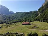 2
2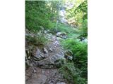 3
3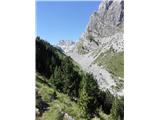 4
4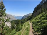 5
5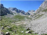 6
6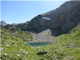 7
7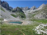 8
8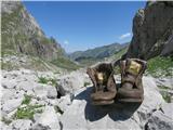 9
9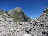 10
10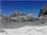 11
11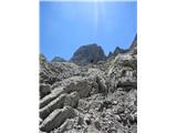 12
12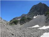 13
13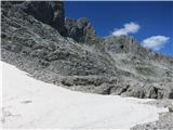 14
14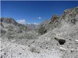 15
15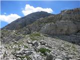 16
16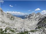 17
17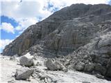 18
18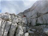 19
19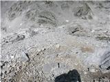 20
20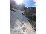 21
21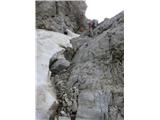 22
22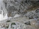 23
23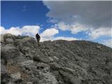 24
24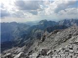 25
25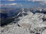 26
26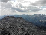 27
27
Discussion about the trail Dolina Ropojana - Maja Jezercë
|
| Trobec17. 08. 2018 |
Oznaka "delno zahtevna označena pot" ne ustreza realnemu stanju (pa ne zato, ker taka oznaka uradno ne obstaja). Pot je vsaj zahtevna, verjetno je še bolj ustrezna oznaka ZZ. Teren je na nekaterih izpostavljenih mestih izredno krušljiv, varoval ni.
Toliko v vednost, da ne bi kdo poti vzel na lahko in bil potem neprijetno presenečen.
|
|
|
|
| Tadej20. 08. 2018 |
Hvala za opozorilo. Sem v opisu spremenil težavnost.
|
|
|