 | Sora - Hom (steep past cemetery)
Hom is a 715 m high peak rising steeply south-west of the village of Sora. The summit, which is partly covered with forest, offers a beautiful vi...
50 min |
 | Briše - Mali vrh
To the west of Polhov Gradec, between the rivers Mala voda and Velika Božna, is a 708-metre-high hill called Mali vrh. From the grassy summit, wh...
1 h 5 min |
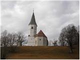 | Okroglice - Sveti Lovrenc above Okroglice
The Church of Saint Lovrenc is located east of Zidanega Most, above the village of Okroglice. From the top of the hill, where the clusius cowslip...
1 h |
 | Gradec - Osojnica
Osojnica is a forested hill located west of Pivka. There is no view from the top, which has a registration box, a stamp and a bench....
45 min |
 | Dobrič (Vedet) - Gora Oljka (by road)
Gora Oljka is a hill located east of Šmartno ob Paki. On the top stands the Church of the Holy Cross, which was built in the mid-18th century. Ju...
50 min |
 | Tržič - Kamnek (Milanova pot)
Kamnek (Kamnik on maps, but also Kamnjek) is a scenic peak above Tržič....
1 h 5 min |
 | Tržič (Slap) - Kamnek (via Dobrivc)
Kamnek (Kamnik on maps, but also Kamnjek) is a scenic peak above Tržič....
1 h |
 | Lučine - Sivka
Sivka is a grassy peak located in the westernmost part of the Polhograje Hills. In good weather, the peak offers a magnificent view from Snežnik ...
50 min |
 | Prelesje - Sivka
Sivka is a grassy peak located in the westernmost part of the Polhograje Hills. In good weather, the peak offers a magnificent view from Snežnik ...
1 h |
 | Planina - Grmada (Planinska gora)
Grmada is an 873m high peak rising west of Planinsko Polje. The summit is overgrown, but from the lookout point just below the summit we have a b...
1 h |
 | Planina (Dolnja Planina) - Grmada (Planinska gora) (via Zavrtniki)
Grmada is an 873m high peak rising west of Planinsko Polje. The summit is overgrown, but from the lookout point just below the summit we have a b...
1 h 5 min |
| Planina (Dolnja Planina) - Grmada (Planinska gora) (via Sv. Duh)
Grmada is an 873m high peak rising west of Planinsko Polje. The summit is overgrown, but from the lookout point just below the summit we have a b...
1 h 5 min |
 | Koroška Bela - Malnež
Malnež is an 846 m high lookout peak of the southern Karavanke mountain range, located on the eastern side of the valley in which the village Kor...
40 min |
 | Zgornja Besnica (Nova vas) - Rovnik (west path)
Rovnik is a 707 m high peak located west of Zgornja Besnica. There is no better view from the top, where there are two benches, a wishing bell an...
40 min |
 | Zgornja Besnica (Nova vas) - Rovnik (east path)
Rovnik is a 707 m high peak located west of Zgornja Besnica. There is no better view from the top, where there are two benches, a wishing bell an...
45 min |
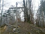
 | Jasen - Ahac
Ahac or St. Ahac is a 799 m high peak located east of Ilirska Bistrica. The summit, which is home to a registration box, a cross and the ruins of...
1 h |
| Vrbovo - Ahac
Ahac or St. Ahac is a 799 m high peak located east of Ilirska Bistrica. The summit, which is home to a registration box, a cross and the ruins of...
1 h |
 | Grad Hošperk - Stari grad
The Old Castle is a 703 m high peak located between Mountain pasture and Uncem. From the summit, where the transmitters are located, the forest a...
40 min |
 | Činžat - Lobnikov vrh
Lobnikov vrh is a forested peak above the Drava Valley, situated between Fala and Ruta. From the east, it loks like a solitary rock due to its di...
1 h |
 | Čepovan (Želinc) - Vrh Skopice
Vrh Skopice is a scenic peak located between the Čepovan valley, the Idrijca valley and the Trebuščice valley. From the top, where there is a reg...
50 min |
 | Brezje nad Kamnikom - Vovar (western way)
An obscure hill in front of the Kamnik mountains. Recently covered by storms, it has been covered with wood harvesting tracks.There is also a sma...
1 h |
| Brezje nad Kamnikom - Vovar (northern way)
An obscure hill in front of the Kamnik mountains. Recently covered by storms, it has been covered with wood harvesting tracks.There is also a sma...
1 h |
 | Log - Pečke (by road)
Pečke is an easily accessible and recently less and less visited peak located north of the main ridge of Pohorje. It receives more visitors only ...
1 h 5 min |
 | Col - Špiček (Špečk)
Špiček (locals call it Špečk) is a peak located north to north-east of Cola. On the summit is a cross in honour of St Hubert and commemorating th...
55 min |
 | Col - Križna gora above Col
Križna gora is a 957 m high peak located north of Cola. The summit, which is forested on the north side, offers a beautiful view to the east, sou...
55 min |
 | Olševek - Apnišče (west path)
Apnišče is a 740 m high mountain located between Možjanca and Štefanja gora. It is the highest point of the Šenčur municipality. There is a bench...
55 min |
 | Olševek - Apnišče (via Šterna)
Apnišče is a 740 m high mountain located between Možjanca and Štefanja gora. It is the highest point of the Šenčur municipality. There is a bench...
55 min |
| Adergas - Apnišče (via Šterna)
Apnišče is a 740 m high mountain located between Možjanca and Štefanja gora. It is the highest point of the Šenčur municipality. There is a bench...
1 h |
 | Blejska Dobrava (cemetery) - Hom pri Bledu (on east slope)
Hom is an 834 m high hill that rises north above the villages Zasip and Podhom near Bled, or south of the village Blejska Dobrava near Jesenice. ...
1 h 5 min |
 | Podhom - Hom pri Bledu
Hom is an 834 m high hill that rises north above the villages Zasip and Podhom near Bled, or south of the village Blejska Dobrava near Jesenice. ...
40 min |
 | Poljane (Spodnje Gorje) - Boršt (by road)
Boršt is a 931 m high vegetated peak located 4 km north-west of Bled, or east of the Mežakla plateau. Between it and the neighbouring peak of Hom...
1 h |
 | Trate (Blejska Dobrava) - Boršt
Boršt is a 931 m high vegetated peak located 4 km north-west of Bled, or east of the Mežakla plateau. Between it and the neighbouring peak of Hom...
1 h |
 | Polhov Gradec - Kucelj above Polhov Gradec (via Ravnek)
Kucelj is a lesser-known peak located between Polhov Gradec and Dvůr pri Polhovem Gradcu. From the 705-metre-high peak, there are views towards G...
1 h |
 | Železniki - Hujska (via Kres)
Hujska is a 706-metre-high peak located above Železniki, more precisely between the Dašnjica and Češnjica streams. On the top there is a bench, a...
45 min |
| Železniki - Hujska
Hujska is a 706-metre-high peak located above Železniki, more precisely between the Dašnjica and Češnjica streams. On the top there is a bench, a...
40 min |
 | Škalske Cirkovce - Smodivnik
Smodivnik is a less visited hill, rising above the Hude hole basin at Dolič on one side and the Velenje basin on the other.There is no summit mar...
45 min |
 | Prevalje - Brinjeva gora (above Prevalje) (via Stations of the Cross)
Brinjeva gora is a popular excursion spot for Prevalj inhabitants, located between the Meža River and the Zelenbreški brok. At the top of the hil...
1 h |
| Prevalje - Brinjeva gora (above Prevalje) (south path)
Brinjeva gora is a popular excursion spot for Prevalj inhabitants, located between the Meža River and the Zelenbreški brok. At the top of the hil...
1 h |
 | Mežica - Štalekarjev vrh (on ski slope)
Štalekarjev vrh is a hill above the former Mežica ski resort. There is no better view from the top, but there is a nice view from the grassy area...
45 min |
 | Selca - Lepo brdo
Lepo brdo is a 778-metre-high hill located above the settlements of Selca and Studeno....
1 h |
 | Lovrenc na Pohorju (cemetery) - Koglerjev vrh (via Hožičev vrh)
Koglerjev vrh is a 698-metre-high, forested peak located south-west of the Šlaus-Kogler organic farm, which is above the village of Lovrenc na Po...
1 h |