Starting point: Povir (410 m)
| Lat/Lon: | 45,6966°N 13,934°E |
| |
Time of walking: 1 h 10 min
Difficulty: easy marked way
Altitude difference: 193 m
Altitude difference po putu: 193 m
Map: Slovenska Istra - Čičarija, Brkini in Kras 1:50.000
Recommended equipment (summer):
Recommended equipment (winter):
Views: 9.652
 | 1 person likes this post |
Access to the starting point:
a) From the Ljubljana - Koper motorway, take the Divača exit and then continue to Divača. From Divača, continue in the direction of Sežana, and after a few kilometres of further driving, you will arrive at Povir, where you will leave the main road and drive left towards the centre of the town. Continue through the centre of the village, then turn left after the railway overpass. Continue past a few more houses and then the asphalt ends. Park a few 100 m further on from the end of the village, in a suitable place on the roadside.
b) First drive to Sežana, then continue along the old road towards Divača. When you reach Povir, leave the main road and drive to the right towards the centre of the village. Continue through the centre of the village, then turn left after the railway overpass. Continue past a few more houses and then the asphalt ends. Park a few 100 m further on from the end of the village, in a suitable place on the roadside.
Path description:
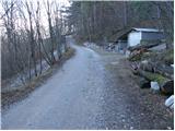
From the starting point, continue along the macadam road, which climbs gently through the forest. The forest soon turns into scrub, and the road, which slowly turns to the right, leads to a marked crossroads, where you continue along the right-hand road in the direction of Stari tabor (Lokev and Strmec on the left). From the crossroads onwards we continue along a rather folded road, which soon leads us to the next crossroads.
Continue straight on in the direction of the easier path to Stari tabor (left the harder path), which only a few metres further on leads us to Hudičkového spodmol, which is only 30 metres from the path.
From the spodmol onwards, walk along the gently sloping road for a while, then reach a small crossroads where you continue along the right, slightly worse road. At the next crossroads, go left, then continue along a much steeper road, which soon turns off to the right, leading to another spodmol (the Spodmol Šprinčnca), which is a 5-minute walk away. Higher up, the road ends, and we continue along the marked path, which is initially joined on the right by a less well-trodden path from the Vilenica cave, and a little further on by a path from the village of Lokev. At both crossroads, continue left and you will easily reach the summit.

We can extend the trip to the following destinations: Stari tabor
Pictures:
 1
1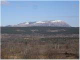 2
2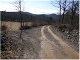 3
3 4
4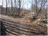 5
5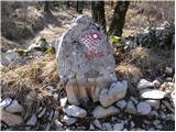 6
6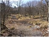 7
7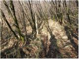 8
8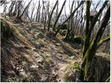 9
9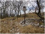 10
10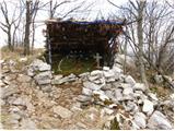 11
11 12
12
Discussion about the trail Povir - Stari tabor
|
| wolphgang21. 02. 2011 |
v petek sem bil med drugim tudi tukaj in moram priznat, da me je kar presenetil z širokim razgledom na prostrano kraško pokrajino
|
|
|
|
| Ingrid7911. 05. 2020 |
Zelo lep sprehod .. Kako blizu imamo tako lepe kotičke. Enkrat moram tudi po težji poti.
|
|
|
|
| darinka44. 09. 2022 18:48:57 |
Zelo lepa tura. Bila sva danes popoldne z Maksijem. Srečala nisva nikogar. Sestopila po daljši oziroma lažji poti. Spotoma šla še na visok hrib. Na vrhu so skale in kamni. Zgubiš se ne , ker je celotna pot markirana.
|
|
|