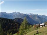
Bukovnik - Lanež (Hojnikova pot)
Starting point: Bukovnik (1327 m)
| Lat/Lon: | 46,434°N 14,7371°E |
| |
Name of path: Hojnikova pot
Time of walking: 2 h
Difficulty: difficult unmarked way
Altitude difference: 598 m
Altitude difference po putu: 600 m
Map: Grintovci 1:25000, KSA 1:50000
Recommended equipment (summer): helmet
Recommended equipment (winter): helmet, ice axe, crampons
Views: 8.353
 | 3 people like this post |
Access to the starting point:
Take the road to Luce (to get here from Mozirje or via Kranjski rak) and follow the road towards the Logar valley, but only as far as the village of Solčava, where you turn right towards Podolševa and Črna na Koroškem. After a while the road ascends and leads to a crossroads, where you turn right in the direction of Črna. Higher up, the road leads to a crossroads at the mountain pass Spodnje Sleme. Here turn right in the direction of Koča na Grohatu and Bukovnik. Soon you will come to the next crossroads, where the forest road to Grohata, closed to traffic, branches off to the left (straight ahead). Park here in one of the small parking lots along the road.
Path description:
From the parking lot, take the upper left-hand road, which crosses the barrier after only a few dozen metres. Just a little further on, you will reach a point where a footpath branches off to the left uphill. The path climbs slightly at first and then crosses the slopes to the south, mostly in a gentle ascent. During the crossing, you cross a number of ravines and some steeper slopes. In some places, there is even a wooden bridge to help us. After a good half an hour's walk, you emerge from the forest onto a forest road. It's just a few steps of a steep climb to Hut na Grohatu.
At the hut, head straight up the slope towards the forest. Look for the trailhead marker on a tree and climb over a pasture fence onto the trail, which runs uphill to the left. Follow this relatively easy-to-follow path through the forest to a small saddle at about 1600 m. At the saddle, turn right and follow the increasingly less visible path to start the ascent below the wall of Lanež. The path goes steeply upwards in some places in the keys and leads us under the most difficult part - the grapple. Here you should put on your helmet, as the gully is loaded with rubble.
The ascent up the rubble gully is quite difficult (grade 1 places), helped by the remnants of the formerly protected path (wedges and crampons). At the exit of the gully we have some very steep climbing on grass, from where it is only a few steps to the top of Lanež.
The descent is even more difficult, so I recommend descending the newly surfaced path over Durce!

Pictures:
 1
1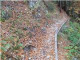 2
2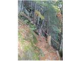 3
3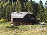 4
4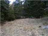 5
5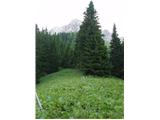 6
6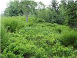 7
7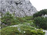 8
8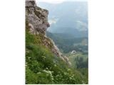 9
9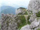 10
10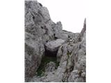 11
11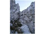 12
12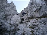 13
13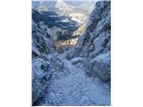 14
14 15
15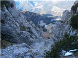 16
16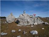 17
17
Discussion about the trail Bukovnik - Lanež (Hojnikova pot)
|
| pohodnik3823. 06. 2013 |
Včeraj po Hojnikovi poti na Lanež,zelo zahtevno saj je grapa zelo založena z gruščem,sestop bi bil vratolomno dejanje,meni je bilo zelo všeč. VIDEO-Po grapi na Lanež-1925m Lp! Tone 
|
|
|
|
| neph7. 07. 2013 |
Odkar je opis poti na tem portalu, se je obisk Hojnikove poti zagotovo povečal, vsaj sodeč po vpisni knjigici na vrhu Laneža
|
|
|
|
| pohodnik387. 07. 2013 |
Sem opazil je kar veliko vpisov,res pa tudi da tisti ki gre na Raduho z Grohata še skoči na Lanež saj je 10 min z poti.
|
|
|
|
| neph8. 07. 2013 |
Zagotovo, veliko ljudi se tudi ne vpiše. Sicer pa sem imel v mislih vpise, kjer izrecno navajajo, da so prišli po Hojnikovi poti.
|
|
|
|
| montura20. 05. 2015 |
Včeraj zelo previdno in skoncentrirano prehodili to pot, čelada obvezna! Na polički pri drugi skobi so ostala oranžna sončna očala  , če/ko jih kdo najde, je vljudno naprošen, da se javi ali jih odloži pri Bukovniku .
|
|
|
|
| mpp18. 07. 2015 |
alternativen OPIS: Od Bukovnika gremo do dostavne ceste, ki pelje k koči na Grohotu in potem takoj po strmi kamniti vlaki proti grebenu, čez čaz se vlaka izravna in zavije v desno čez pobočja, tam zavijemo po peš poti v levo strmo v breg. Pot nas pripelje na Prosenčev vrh. Nato samo sledimo občasno precej zaraščeni poti po grebenu. Razgledi čudoviti. Čez čas se priključi zgoraj opisana pot od koče. Ko pridemo pod steno se držimo v desno. V pomoč so slabo vidne, obledele oznake (puščice). Opis plezalnega dela je zgoraj. Lepa pot, samotna Kje je omenjena vpisna knjiga? Žal nisem imel s seboj škarij za veje, na določenih delih bi prišle prav.
|
|
|
|
| pohodnik3820. 06. 2016 |
Nekaj utrinkov z sobotnega potepanja na tej poti.Bilo je odlično še boljše bi bilo če ne bi rabil hitet zaradi napovedanih ploh-neviht.Le teren je pa bil razmočen od vsakodnevnega dežja. SLIKE in osebni vtisi z poti Lp! Tone
|
|
|
|
| garmont10. 06. 2018 |
Pot je v spodnjem delu, od prečenja pašne ograje naprej zaradi podrtih dreves neprehodna.  Bolje se je na nekoč markiran greben podati brezpotno že prej. Je pa tudi na grebenu podrtih nekaj velikih dreves in je potrebna precejšnja telovadba, da se prebiješ čeznje. 
|
|
|
|
| zokipoki16. 07. 2019 |
Danes na Lanežu po Hojnikovi. Pot je od prečenja pašne ograje pa do sedla, na treh mestih še vedno težje prehodna, vendar z malo telovadbe to ne povzroča težav. V sami grapi pa brez posebnosti.
|
|
|