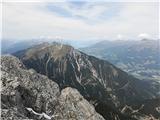
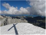
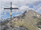
 | Vršič - Prisank / Prisojnik (Slovenian way)
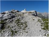
Prisank is a 2547 m high mountain located above the valleys of Mlinarica, Krnica and Suha Pišnica. From the top of the peak, where the registrati...
3 h 30 min |
| Erjavčeva koča na Vršiču - Prisank / Prisojnik (Slovenska pot)
Prisank is a 2547 m high mountain located above the valleys of Mlinarica, Krnica and Suha Pišnica. From the top of the peak, where the registrati...
3 h 45 min |
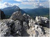
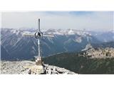
 | Sella Nevea - Prestreljenik (via Rifugio Gilberti)
Prestreljenik is a 2499 m high mountain located in the heart of the Kanin Mountains. From the top, where the Aljaž Tower-shaped registration box ...
4 h 15 min |
| Sella Nevea - Prestreljenik (via 636)
Prestreljenik is a 2499 m high mountain located in the heart of the Kanin Mountains. From the top, where the Aljaž Tower-shaped registration box ...
3 h 45 min |
 | Bodenbauer - Hochstuhl/Stol
At 2236 m, Stol is the highest peak in the Karavanke Mountains. From the summit, which has a registration box and a stamp, we have a beautiful vi...
4 h 30 min |
 | Ljubelj - Loibler Baba/Košutica (via koča na Ljubelju)
Loibler Baba (also Ljubeljska Baba) is a scenic mountain located north of the western ridge of Košuta. From the top, where there is a small cross...
2 h 45 min |
 | Bučan - Loibler Baba/Košutica
Loibler Baba (also Ljubeljska Baba) is a scenic mountain located north of the western ridge of Košuta. From the top, where there is a small cross...
2 h 45 min |
 | Bodenbauer - Vertatscha/Vrtača
Vertatscha is a 2181 m high peak located to the east of Stol. From the top of the peak, on which stands a large wedge, we have a beautiful view o...
4 h 45 min |
 | Koča pod slapom Rinka - Planjava
Planjava is a small mountain range to the east of Kamnik saddle. It has two peaks, one eastern and one western. There is a marked trail to the ea...
4 h 45 min |
| Planina Podvežak - Planjava (via Srebrno sedlo)
Planjava is a small mountain range to the east of Kamnik saddle. It has two peaks, one eastern and one western. There is a marked trail to the ea...
4 h 15 min |
 | Planina Podvežak - Planjava (via Škarje)
Planjava is a small mountain range to the east of Kamnik saddle. It has two peaks, one eastern and one western. There is a marked trail to the ea...
4 h 45 min |
 | Dom pod Storžičem - Storžič (via Škarjev rob)
Storžič is a 2132 m high mountain located in the western part of the Kamink Savinja Alps. From the top with a cross there are beautiful views of ...
3 h |
 | Jekarica - Storžič
Storžič is a 2132 m high mountain located in the western part of the Kamink Savinja Alps. From the top with a cross there are beautiful views of ...
3 h |
| Tržiški graben - Storžič (via Javorniški preval)
Storžič is a 2132 m high mountain located in the western part of the Kamink Savinja Alps. From the top with a cross there are beautiful views of ...
3 h 40 min |
 | Koča pod slapom Rinka - Brana
Brana is a mountain above Kamnik saddle. The view from the spacious summit, which has a registration box and a small cross, is very beautiful. Pl...
3 h 45 min |
 | Erjavčev rovt - Mittagskogel/Kepa
Kepa, also Jepa, or Mittagskogel in German, is a scenic mountain in the western Karawanks, located on the border ridge between Slovenia and Austr...
3 h 50 min |
| Ravne - Mittagskogel/Kepa
Kepa, also Jepa, or Mittagskogel in German, is a scenic mountain in the western Karawanks, located on the border ridge between Slovenia and Austr...
4 h 15 min |
 | Iličev rovt / Illitsch Rauth - Mittagskogel/Kepa (path 680)
Kepa, also Jepa, or Mittagskogel in German, is a scenic mountain in the western Karawanks, located on the border ridge between Slovenia and Austr...
3 h |
 | Kriška planina - Kalška gora (via Zvoh)
Kalška gora is located between Kalški greben and Kokrsko sedlo. From the top, which is covered with grass, there is a beautiful view towards the ...
4 h 45 min |
| Dom na Gospincu - Kalška gora (via Zvoh)
Kalška gora is located between Kalški greben and Kokrsko sedlo. From the top, which is covered with grass, there is a beautiful view towards the ...
4 h 45 min |
 | Podnar / Bodenbauer - Prešernova koča na Stolu
Prešernova koča na Stolu, is located just a few metres below the summit of the 2198 m high Mali Stol. From the hut or the nearby Mali Stol, we ha...
4 h 25 min |
 | Kriška planina - Kalški greben (via Zvoh)
Kalški greben is 2224 m high and is the highest peak of the eponymous ridge. The summit, which has a registration box and a stamp, offers a beaut...
4 h 10 min |
| Dom na Gospincu - Kalški greben (via Zvoh)
Kalški greben is 2224 m high and is the highest peak of the eponymous ridge. The summit, which has a registration box and a stamp, offers a beaut...
4 h 10 min |
| Planina Jezerca - Kalški greben (via Dom na Krvavcu and Zvoh)
Kalški greben is 2224 m high and is the highest peak of the eponymous ridge. The summit, which has a registration box and a stamp, offers a beaut...
4 h 25 min |
 | Bodenbauer - Ovčji vrh (Kozjak) / Geissberg (Kosiak) (direct way)
Ovčji vrh or Kozjak, or Geissberg or Kosiak in German, is a 2024 m high peak located north of the main ridge of the Karavanke Mountains. The peak...
3 h |
| Bodenbauer - Ovčji vrh (Kozjak) / Geissberg (Kosiak) (via Klagenfurter Hütte)
Ovčji vrh or Kozjak, or Geissberg or Kosiak in German, is a 2024 m high peak located north of the main ridge of the Karavanke Mountains. The peak...
3 h 15 min |
 | Bodenbauer - Bielschitza/Svačica
Bielschitza is a less prominent peak in the main ridge of the Karavanke. It is located between Vertatscha and Stol and is slightly offset to the ...
3 h 15 min |
 | Ravenska Kočna - Velika (Koroška) Baba (via Jenkova planina)
Velika is a 2127 m high mountain on the border ridge above the Ravenská Kočna valley on the Slovenian side and above the Bela valley (Belska Kočn...
3 h 30 min |
 | Goldberg - Torkofel
Torkofel is the highest peak of the Jauken lookout ridge, which stretches north of the Ziljska valley. From the top with a cross there is a beaut...
3 h 45 min |
 | Jochalm - Reißkofel (235-1)
Reißkofel is a 2371 metre high mountain in the Zilj Alps. The summit on which the cross stands also has a registration box. The view from the top...
3 h |
 | Jochalm - Reißkofel (path 235)
Reißkofel is a 2371 metre high mountain in the Zilj Alps. The summit on which the cross stands also has a registration box. The view from the top...
3 h 25 min |
 | Reißkofelbad - Kleiner Reißkofel
Kleiner Reißkofel is a 2161 metre high mountain east of Reißkofl. From the summit on which the cross stands, you can enjoy a beautiful view of th...
3 h 30 min |
 | Göriach - Scharnock
Scharnock is a scenic peak located in the Schladminger Tauern mountain group. From the summit on which the cross stands, there is a beautiful vie...
3 h 30 min |
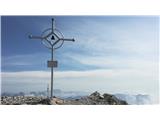
 | Dom v Tamarju - Srednja Ponca / Ponza di Mezze
Srednja Ponca is a 2228m high peak rising steeply above Tamar, Planica and the Mangart valley. From the summit on which the stamp is located, the...
3 h 15 min |
 | Plockenpass - Monte Floriz
Monte Floriz is a 2184m high grassy peak located south of the Marinelli hut. From the summit there is a very fine view of the Coglians group, and...
3 h |
 | Sella Nevea - Monte Bila pec
White oven, or Italian. Monte Bila pec is a 2146 m high mountain located to the north of the main Kanin ridge. From the top, where there is a reg...
2 h 45 min |
 | Planina Pecol - Strma peč / Monte Cimone (path 640 via notch Vandul)
Strma peč is located to the west of Jôf di Montasio, specifically between the Reklanica and Dunja valleys. From the summit, where the bivouac onc...
4 h |
 | Planina Pecol - Strma peč / Monte Cimone (path 641 on the slope of Viene)
Strma peč is located to the west of Jôf di Montasio, specifically between the Reklanica and Dunja valleys. From the summit, where the bivouac onc...
4 h 45 min |
 | Rifugio Pederü - Croda del Beco / Seekofel
Croda del Beco (German: Seekofel, Ladin: Sass dla Porta) is a 2,810-metre-high mountain rising steeply above Lago di Braies (Pragser Wildsee). It...
3 h 45 min |
| Rifugio Ra Stua - Croda del Beco / Seekofel
Croda del Beco (German: Seekofel, Ladin: Sass dla Porta) is a 2,810-metre-high mountain rising steeply above Lago di Braies (Pragser Wildsee). It...
3 h 35 min |
 | Fiames - Punta Fiames
Punta Fiames is a 2240-metre peak located north of Cortina d'Ampezzo. The mountain is particularly popular among those who like protected climbin...
3 h 30 min |
 | Bergheimat - Dachskofel (via Scharnik)
Dachskofel is a 2373m high mountain in Hohe Tauern in Austria above the city of Irschen and near the Lamnitzsee. A wooden cross is placed on the ...
3 h 50 min |
 | Spodnje Sleme - Obel kamen (Olševa)
Obel kamen is a 1911 m high peak located in the Olševa Ridge. On the summit there is a boundary stone marked RS XXII 1, the cross and the registr...
3 h 30 min |
 | Dolina Dobri do - Bobotov kuk
Bobotov kuk is the highest peak of Durmitor. It is the highest peak of the XXXXXX range. The southern approaches are the shortest and the eastern...
2 h 45 min |
 | Passo di Sant'Antonio - Monte Aiarnola (via normale)
Monte Aiarnola is a mountain in the easternmost part of the Sexten Dolomites group. It offers a fine view of the western Carnic Alps, the Marmaro...
3 h 30 min |
 | Cima Sappada - Creton di Tul
Creton di Tul is a 2288 meter high mountain in a mountain group Pesarina Dolomites in the Carnic Alps in Italy, south of a city of Sappada and ju...
3 h 30 min |
 | Cima Sappada - Creta Forata
Creta Forata is a 2462 meter high mountain in a mountain group of the Pesarina Dolomites in the Carnic Alps in Italy, south of a city of Sappada....
4 h |
 | Oberissalm - Vordere Sommerwand (normal path)
The Sommerwand is a relatively long ridge rising like a mighty rock barrier above the upper part of the Oberbergtal valley, hiding from the valle...
2 h 40 min |
 | Gschnitz - Kalkwand (zahodni pristop iz Gschnitza preko Pinnisjocha)
Kalkwand is a large mountain in the eastern part of the Habicht group of the central Stubai Alps. Thanks to its attractive views, the low difficu...
3 h 45 min |
 | Sella di Razzo - Clapsavon (via 210 & 212)
Clapsavon is a 2462 m high mountain in Carnic Alps in Italy, and it is situated just short of 1 hour hiking distance to the west from Monte Biver...
3 h |
 | Sella di Razzo - Bivera (via Forcella Chiansaveit, Monte Clapsavon, Forcella de Bivera)
Monte Bivera is a 2474 m high mountain in Carnic Alps in Italy, and it is situated just short of 1 hour hiking distance to the east from Monte Cl...
4 h |