Pred Belo - Ojstrica (via Skok and Šraj pesek)
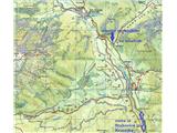
Starting point: Pred Belo (571 m)
| Lat/Lon: | 46,3188°N 14,6005°E |
| |
Name of path: via Skok and Šraj pesek
Time of walking: 6 h
Difficulty: very difficult unmarked way, difficult marked way
Altitude difference: 1779 m
Altitude difference po putu: 1779 m
Map: Grintovci 1: 25.000
Recommended equipment (summer): helmet
Recommended equipment (winter): helmet, ice axe, crampons
Views: 9.752
 | 6 people like this post |
Access to the starting point:
From Kamnik or Stahovica we drive into the valley of Kamniška Bistrica, approx. 2 km further from the parking lot at the lower station of the gondola for Velika planina we drive to the bridge over the Kamniška Bele river and approx. 100 m further on the right side of the road in the forest we drive to a small parking lot where we see the mountain signs and the start of the marked trail to Presedljaj, Konj and Korošica.
It is also possible to take the forest road before the bridge and after about 100 m park above the river, but this path is often muddy and you have to cross the river, which is sometimes not possible due to the higher water level.
Path description:
From the parking lot, continue first along the marked path into the forest, which then soon joins a wide dirt track and runs more or less along the Kamniška Bela riverbed, which is still watery at first, but then has no water on the surface. After about half an hour of comfortable walking you reach a marked crossroads, where you turn left onto an unmarked trail to The Orglice waterfall and a hunting trail over Skok and Šraj pesek, and to the right or straight ahead is a marked trail to Presedljaj, Konja and Korošica.
The track then slowly narrows into a comfortable path that runs right along the usually dry Kamniška Bela riverbed and leads to the lower pools of the Orglice waterfall in just over 10 minutes. Before it, turn right up a less beaten track, which runs along another smaller dry torrent bed and after about 200 m cross it to the left and turn into a steeper forest slope. Usually there are already belays set up at this point, as this approach is also the closest to many climbers below Vežica from the Kamnik side.
The initially quite steep and narrow path soon bends to the left and runs for some time parallel above the torrent, which also brings water for the aforementioned waterfall. The trail is easy to follow, climbs gently and passes through grasses and sparse woods, a little on the right, a little on the left side of the stream and we stick to it until the end, when we come to large rocks and the valley's head. There we cross the riverbed to the right and head back up the steeper forest slope, which then leads us in switchbacks in just over 15 minutes to the base of the Jump, which has three small stepped rocks in succession (difficulty rating II to III). In summer and when there is a drought, the rock is usually dry, and when it is wet it causes further inconvenience, but with some experience and climbing sense you will be able to cope with it; for the descent it is advisable to use a rope (30 m is sufficient) and an abseil, as there are wedges with crampons in two key places for this purpose.
Once you have climbed the Jump, head left above it to rejoin the clearly visible track, which now climbs steeper, first through the grasses and then through the last remnant of the forest. There are also some small rocks on the path in this part and, as we are making detours, we have to be careful not to let any potential ascenters get through them. When you come out of the forest, you will see the mighty walls of Vršakov and Vežica and the Šraj sand scree ahead of you and then to your right. Up the ridge, walk more to the right and closer to the walls, and at the end of the scree slope - opposite a larger rock cavity, climb over a rock step and then over lane of dwarf pines. Shortly afterwards, we get a nice view of the Petkovy meadows below us and the whole of Ojstrica from the south side. The Petkove meadows are indeed a huge, flat and green meadow at this altitude, with the path from Srebrno sedlo (and from the Hut on Kamnik saddle) descending to them from the left, and the compact walls of Lučki Dedec to the right. The path from Petkovi njivy to Kocbekov dom na Korošici is short, but not yet marked from this side, and if you take it on the principle: the shortest is the closest, you may again be faced with the high dwarf pines.
From the beautifully arranged Home on Korošice, the best way to Ojstrica is to do a circular tour, up the east (right) ridge and back along the west or south ridge to the home, and from the home onwards everything is marked and marked.
The route up from the valley is also suitable in summer, as you have shade under Vršaki and Vežica and a pleasant coolness for most of the morning, but you get plenty of sun on the descent in the afternoon, but the way down is still less strenuous.
Walking time: approx. 4 hours to Korošica and another 1. 5 to 2 hours to the summit.

Pictures:
 1
1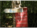 2
2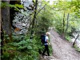 3
3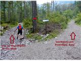 4
4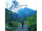 5
5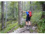 6
6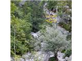 7
7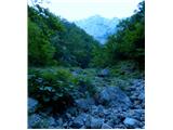 8
8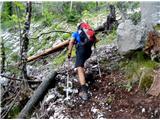 9
9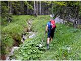 10
10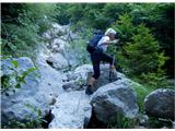 11
11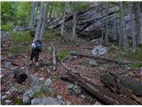 12
12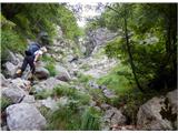 13
13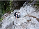 14
14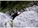 15
15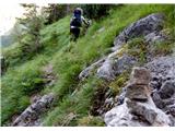 16
16 17
17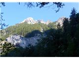 18
18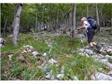 19
19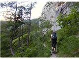 20
20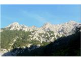 21
21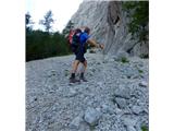 22
22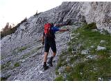 23
23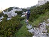 24
24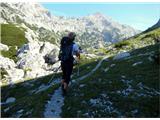 25
25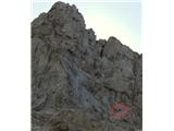 26
26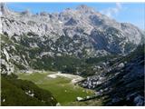 27
27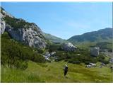 28
28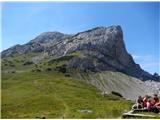 29
29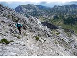 30
30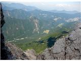 31
31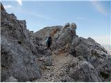 32
32 33
33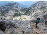 34
34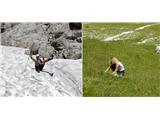 35
35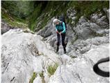 36
36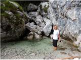 37
37
Discussion about the trail Pred Belo - Ojstrica (via Skok and Šraj pesek)
|
| ljubitelj gora11. 07. 2015 |
Manjka tudi pod zahtevnost: Zelo zahtevno brezpotje vsaj tam, kjer je treba plezat, slika 14-15 pred temi skoki in nad skoki pa je res steza. Slika 13 res je steza v levo a se konča na robu prepada. Vrjetno je steza v levo, ker večina ne najde lažjega prehoda do Korošice in se vrne nazaj v dolino. Povratek mimo Korošice, Presedljaj in v dolino.
|
|
|
|
| franca12. 07. 2015 |
Slika 13: steza se konča. Če gremo po njej do konca, preplezamo par metrov naravnost (desno) navzgor (lahko) in smo v strmem gozdu. Tu je obvoz za skok, kadar je mokra skala. Tudi ta gozdni vzpon ni prav lahek, strmina je precejšnja, kakšnega plezanja pa ni več. Le na koncu je malo teže najti prehod skozi rušje.
|
|
|
|
| klacki12. 07. 2015 |
Sva s punco pred časom opravila to pot, saj je nama tisti del ostal še neraziskan in sva šla in pred skom sva šla še do Kamniške jame (pot lepa, sam strma ko sto bogov, kar grizeš v tist breg), potem pa dol pa spet gor proti Šraj pesku, nisva potem šla naravnost ven čez skoke ampak po poti v levo in nato malo poplezala (tisti, ki niso navajeni malo prezanja naj raje ne hodijo tu čez brez štrika, da se kaj ne zaštrika  !!!), potem pa gasa po celem tistem grebenu in sva prišla do šraj peska, ampak v levo stran melišča potem pa pičila do Korošice na šnopc pa pir , potem pa prek Presedljaja nazaj v Kamniško Super za hodit, mir, ne srečaš žive duše...res lep konec Kamniško -Savinjskih.
|
|
|
|
| gams113. 07. 2015 |
tako kot sem jaz zasledil, se tega Skoka lahko izogneš, če greš čez Najnar štant, ampak kako zahtevno in kako orientacijsko problematično je pa to v primerjavi z opisano potjo, ki je zelo dobro in logično opisana.
|
|
|
|
| garmont13. 07. 2015 |
Lovska steza čez Najnar štant je orientacijsko zahtevnejša od zgoraj opisane poti. Na enem krajšem delu poplezaš (1stopnja),na večih delih pa je izpostavljena. Lahko bi rekel točno tako ,kot že nekdo drug na tem forumu:Kdor ni Skoku dorasel ,se tudi na tej stezi ne bo počutil najbolje.
|
|
|
|
| franca14. 07. 2015 |
V komentarjih (o sliki 13 itd.) ne govorimo o poti čez Najnar štant, ampak o (brez)poti, ki gre skozi gozd levo od Skoka. Tam, kjer pridemo do grape s skokom, gremo še malo levo po poti, splezamo par metrov po skalah v desno in iščemo najboljše prehode po gozdu. V mokrem varneje kot čez Skok, tudi malo lažje.
|
|
|
|
| garmont14. 07. 2015 |
@Gams1 sprašuje o poti čez Najnar štant in ne o obvozu Skoka.
|
|
|
|
| gams114. 07. 2015 |
ali je na tem forumu oz.portalu še kje kaj bolj konkretno napisanega kot piše pod naslovom: Korošica čez Šraj pesek in Najnar štant?!, Garmontove opise sem sicer prebral in pogledal slike, a priznam, da verjetno ne bi našel začetka te poti.
|
|
|
|
| dprapr14. 07. 2015 |
Tu je opis obeh poti (V. Habjan: Brezpotja).
In ocenjeno je z II, kar je seveda realna ocena skoka.
|
|
|
|
| Volk14. 07. 2015 |
Lovska pot čez Najnar štant je seveda neprimerljivo lažja od Skoka. Tudi obvoz, ki ga lepo opisuje franca je malenkost težji od poti čez Najnar štant. Sam Skok je dejansko plezanje II (gladko, dokaj neuporabni stari klini). V sestopu (sploh mokrem) vam zna Skok brez vrvi povzročiti hude težave. Morda le v vednost - GRS je tamkaj posredovala že kar nekajkrat. Lp.
|
|
|
|
| gams116. 07. 2015 |
hvala vsem za komentarje in nasvete; torej, če poenostavim: gor čez Skok se še nekako spleza, za dol pa se ga je povprečnemu planincu brez štrika bolje izogniti in ker tisti obvozi mimo Skoka po desni navzdol niso ziher in tudi pot čez Najnar štant ne, si je od Korošice nazaj najbolje vzeti čas, za enostavnejšo in daljšo varianto hoje po markirani poti mimo Lučkega dedca čez Presedljaj v dolino Kam.Bele.
|
|
|
|
| garmont17. 07. 2015 |
Točno tako.
Si pa ob poti čez "Skok" ogledaš še naravno zmamenitost...Velb,ki v opisu poti ni omenjen.
|
|
|
|
| subaru13. 08. 2015 |
Včeraj prehodil to pot. Dokaj lahko sledljiva, strma in kar dolga.Razen skoka kakšnih težav ni.
Sam skok pa dokaj zoprn, predvsem zaradi gladkih skal. Za povprečnega planinca, ki ni vajen kakšne "plezarije " pa priporočam varovanje z vrvjo. Tudi v suhem. Sestopa čez skok se pa vsaj jaz ne bi lotil brez vrvi.
Drugače pa čudovita turca, mir, drugačni pogledi na Zeleniške špice.
|
|
|