V Koncu - Dolgi hrbet (via Kokrsko sedlo)
Starting point: V Koncu (900 m)
| Lat/Lon: | 46,342°N 14,5682°E |
| |
Name of path: via Kokrsko sedlo
Time of walking: 5 h
Difficulty: very difficult marked way
Altitude difference: 1573 m
Altitude difference po putu: 1700 m
Map: Kamniške in Savinjske Alpe 1:50.000
Recommended equipment (summer): helmet, self belay set
Recommended equipment (winter): helmet, self belay set, ice axe, crampons
Views: 26.707
 | 3 people like this post |
Access to the starting point:
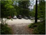
Drive into Kamnik and follow the road towards the Kamnik Bistrica valley. From your home in Kamniška Bistrica, continue driving along the forest road, which takes you higher up to a crossroads where you continue straight ahead (right Jermanca, starting point for Kamniško sedlo). The road then takes you past Žagana peči to the parking lot at the lower station of the cargo cableway to Kokrsko sedlo.
After the new traffic sign, driving from the Kamniški Bistrica hut to the V Koncu parking lot is forbidden, which extends the journey by almost an hour.
Path description:
From the parking lot at the cargo cableway, follow the footpath towards Kokrsko sedlo and Grintovec. The path through the forest climbs gently at first, but this part of the path is short. After a few minutes of walking, the path starts to climb steeply and a little higher up we are helped by the fixed safety gear, which come in handy when the ground is wet and slippery (not difficult in dry conditions). However, the well visible and still steep trail starts to turn slightly to the right higher up. The steepness then eases for a short time and the path leads us out of the forest onto the avalanche slopes below Kokrsko sedlo. Here the path straightens out again and, with increasingly beautiful views (these are the most beautiful of the peaks above the Kamnik Bistrica valley), climbs along the foot of the Kalška gora and Malá vrh walls. Easy to follow, but due to a lot of rocks (slightly overgrown scree) on the way, the path is tiring, and after a good 2 hour walk leads us to Kokrsko sedlo, where Cojzova koča (Cojz's hut) stands.
From the saddle, continue right in the direction of Grintovec, Kočna and Skute. The path climbs steeply immediately above the saddle and leads us slightly higher to a crossroads where the path to the bivouac under Grintovec and Skuta branches off to the right (straight Grintovec over Streha and Kočna). We take this initially slightly less visible path, which leads us in a moderate ascent to a picturesque passage over the Little Necks. Beyond the narrow passage Mala vratca, the path begins to descend a steep and occasionally slightly exposed slope. At the end of the descent, which takes us about 100 vertical metres, we are helped by a few wedges. There is a gully crossing and then a climb through the high mountains to the bivouac below Grintovec.
From the bivouac, we continue along the marked trail, which quickly leads us to a crossroads. Continue straight in the direction of Skute and Grintovec (right Kamniško sedlo, Rinke and Turska gora) along a relatively gently sloping path, which soon leads to the next crossroads. Again, continue along the left path (right Skuta), which leads us further across a karst world full of scrapes and potholes. Next, carefully follow the markings which, after a short climb, lead us to Mlinarsko sedlo, where we join the path from Jezersko. Here we are at a crossroads, where we turn right in the direction of Dolgega hrbta and Skute (Grintovec on the left). From here on we have just over 30 minutes of protected climbing trail to the top of Dolgega hrbta. At first the route leads us over the southern slopes of Long Back, but with the help of numerous fixed safety gear the route quickly leads us back to the ridge. The path continues along the ridge, and in places passes over 1000m precipices. This path, which is a slip hazard in the wet, soon leads to the summit of Long Back. V Koncu - Cojzova koča 2:15, Cojzova koča - bivouac pod Grintovcem 1:15, bivouac pod Grintovcem - Dolgi hrbet 1:30.

We can extend the trip to the following destinations: Štruca,
Skuta
Pictures:
 1
1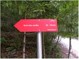 2
2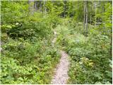 3
3 4
4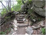 5
5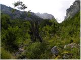 6
6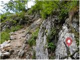 7
7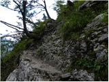 8
8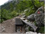 9
9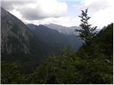 10
10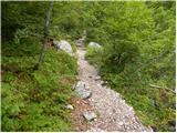 11
11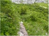 12
12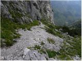 13
13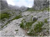 14
14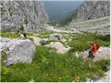 15
15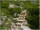 16
16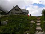 17
17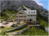 18
18 19
19 20
20 21
21 22
22 23
23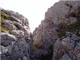 24
24 25
25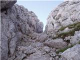 26
26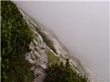 27
27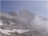 28
28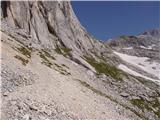 29
29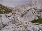 30
30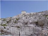 31
31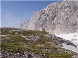 32
32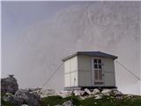 33
33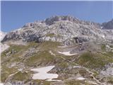 34
34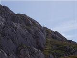 35
35 36
36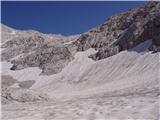 37
37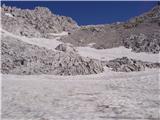 38
38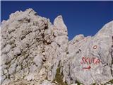 39
39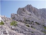 40
40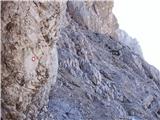 41
41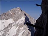 42
42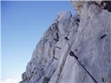 43
43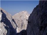 44
44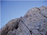 45
45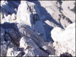 46
46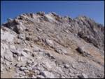 47
47 48
48
Discussion about the trail V Koncu - Dolgi hrbet (via Kokrsko sedlo)
|
| pohodnik3810. 08. 2012 |
Prejšnjo nedeljo prehodil Dolgi hrbet vedar v obratni smeri od Skute do Mlinarskega sedla,zelo zahtevno,je pa pot brez posebnosti varovala pa v dobrem stanju  NEKAJ SLIK Z DOLGEGA HRBTA NEKAJ SLIK Z DOLGEGA HRBTA
|
|
|
|
| nincokl3. 07. 2013 |
Če kdo ve kakšne so kaj razmere na tej poti na dolgi hrbet,bi šel v soboto.....hvala za info..
|
|
|
|
| lenart3. 07. 2013 |
Danes sem šel iz Mlinarskega sedla preko Dolgega hrbta na Skuto. Razmere okej, problem je samo pot iz Skute do bivaka, kjer je eno precej strmo snežišče... brez zimske opreme se mi ne zdi pametno. Tudi ostali so se tukaj obračali
|
|
|
|
| kwhtre4. 07. 2013 |
@lenart: si napisal da je problematična pot od Skute do bivaka zaradi snežišča. Si to mislil bivak pod Skuto ali bivak pod Grintovcem ?
Zato sprašujem, ker sem nameraval ta vikend od Cojzove koče čez mala vratca do bivaka pod Grintovcem in od tam na Skuto, pa me zanima če je še potrebno da s sabo vzamem cepin in dereze.
|
|
|
|
| _sandra_4. 07. 2013 |
če greš iz Skute proti bivaku pod Grintovcem je še sneg, gotovo je tudi lenart to mislil..
|
|
|
|
| navdušena2. 08. 2015 |
Kako pa, če gremo iz Skute neposredno na Dolgi hrbet? Ima kdo fotografije s te poti - kako izgleda?
|
|
|
|
| smatjaz2. 08. 2015 |
Po kateri poti si mislila iti gor in po kateri dol?
|
|
|