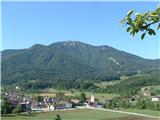
 | Ravne - Črna prst (via Orožnova koča)
On the northern slope of the Črna prst summit head, you can see the black soil from which the mountain takes its name. Črna prst is known for its...
3 h 5 min |
 | Kocenpohar - Črna prst
On the northern slope of the Črna prst summit head, you can see the black soil from which the mountain takes its name. Črna prst is known for its...
2 h 45 min |
| Ravne - Črna prst (via planina za Črno goro)
On the northern slope of the Črna prst summit head, you can see the black soil from which the mountain takes its name. Črna prst is known for its...
3 h 25 min |
 | Zalog - Tolsti vrh
Tolsti vrh, located to the west of Storžič, is also the highest peak of the Kriška Gora, a mountain range rising steeply above the central Gorenj...
3 h |
 | Tržič - Tolsti vrh
Tolsti vrh, located to the west of Storžič, is also the highest peak of the Kriška Gora, a mountain range rising steeply above the central Gorenj...
3 h 15 min |
| Povlje - Tolsti vrh
Tolsti vrh, located to the west of Storžič, is also the highest peak of the Kriška Gora, a mountain range rising steeply above the central Gorenj...
2 h 45 min |
 | Leskova dolina - Snežnik
Snežnik or Veliki Snežnik is the highest peak in the near and far surroundings with a height of 1796 m. It offers a beautiful view over most of S...
3 h 15 min |
 | Mašun - Snežnik
Snežnik or Veliki Snežnik is the highest peak in the near and far surroundings with a height of 1796 m. It offers a beautiful view over most of S...
4 h |
 | Brezje pri Tržiču - Dobrča (via koča na Dobrči)
Dobrča is a 1634 m high mountain located between Begunje and Tržič. From the top, where the registration box with the stamp is located, we can se...
3 h |
 | Zadnja vas - Dobrča
Dobrča is a 1634 m high mountain located between Begunje and Tržič. From the top, where the registration box with the stamp is located, we can se...
3 h |
| Hudi Graben - Dobrča (via Koča na Dobrči)
Dobrča is a 1634 m high mountain located between Begunje and Tržič. From the top, where the registration box with the stamp is located, we can se...
3 h |
 | Slatna - Dobrča
Dobrča is a 1634 m high mountain located between Begunje and Tržič. From the top, where the registration box with the stamp is located, we can se...
3 h |
 | Begunje (Preska) - Dobrča
Dobrča is a 1634 m high mountain located between Begunje and Tržič. From the top, where the registration box with the stamp is located, we can se...
3 h |
 | Bistrica pri Tržiču - Dobrča
Dobrča is a 1634 m high mountain located between Begunje and Tržič. From the top, where the registration box with the stamp is located, we can se...
2 h 55 min |
| Brezje pri Tržiču - Dobrča (by road)
Dobrča is a 1634 m high mountain located between Begunje and Tržič. From the top, where the registration box with the stamp is located, we can se...
2 h 45 min |
 | Tuškov Grič - Blegoš (via Črni vrh)
Blegoš is a 1562 m high mountain located between Selška and Poljane Sora. From the grassy summit, on which there is a stamp and a registration bo...
2 h 45 min |
 | Dom Trilobit - Barentaler Kotschna/Struška
Barentaler Kotschna is a small mountain range located between Stolo or Belščica and Golica. From Veliki vrh, as the highest peak of the mountain ...
3 h |
| Rute (Zavrh) / Bärental - Barentaler Kotschna/Struška (via Bärensattel)
Barentaler Kotschna is a small mountain range located between Stolo or Belščica and Golica. From Veliki vrh, as the highest peak of the mountain ...
2 h 45 min |
 | Tuškov Grič - Porezen (by road)
Porezen is a 1630 m high mountain located between Davča and Baška Grapa. From the top, where a large NOB monument stands, we have a beautiful vie...
3 h 5 min |
 | Raspet - Porezen (on ridge of Cimprovka)
Porezen is a 1630 m high mountain located between Davča and Baška Grapa. From the top, where a large NOB monument stands, we have a beautiful vie...
2 h 45 min |
 | Poče - Porezen (gentle path)
Porezen is a 1630 m high mountain located between Davča and Baška Grapa. From the top, where a large NOB monument stands, we have a beautiful vie...
2 h 45 min |
 | Jesenica - Porezen
Porezen is a 1630 m high mountain located between Davča and Baška Grapa. From the top, where a large NOB monument stands, we have a beautiful vie...
2 h 55 min |
 | Jesenica - Porezen (via Dom na Poreznu)
Porezen is a 1630 m high mountain located between Davča and Baška Grapa. From the top, where a large NOB monument stands, we have a beautiful vie...
3 h |
 | Poče - Porezen (via Labinjske lehe)
Porezen is a 1630 m high mountain located between Davča and Baška Grapa. From the top, where a large NOB monument stands, we have a beautiful vie...
3 h 15 min |
| Poče - Porezen (winter way)
Porezen is a 1630 m high mountain located between Davča and Baška Grapa. From the top, where a large NOB monument stands, we have a beautiful vie...
3 h 25 min |
 | Planina pod Golico - Kahlkogel/Golica (via Suha saddle)
Kahlkogel is an unvegetated peak located north of Jesenice. From the top, which has a registration box, there is a beautiful view of the western ...
3 h |
 | Dom Pristava in Javorniški Rovt - Kahlkogel/Golica (via mountain hut)
Kahlkogel is an unvegetated peak located north of Jesenice. From the top, which has a registration box, there is a beautiful view of the western ...
2 h 45 min |
 | Stara Fužina - Pršivec (direct way)
Lookout Mountain is located above Lake Bohinj. The view is extensive on all sides. Triglav and the mountains around it can be seen, and on the ot...
3 h 45 min |
 | Mače - Javorov vrh (Mačenska pot)
Javorov vrh (also Javorjev vrh according to some records) is a 1434 m high mountain located northeast of Preddvor. From the top, which has a regi...
2 h 50 min |
| Mače - Javorov vrh (via Kozjek)
Javorov vrh (also Javorjev vrh according to some records) is a 1434 m high mountain located northeast of Preddvor. From the top, which has a regi...
3 h |
 | Mače - Bašeljski vrh
Bašeljski vrh is a 1744 m high mountain located between Mali Grintovec and Storžič. From the top, where there is a bench and a registration box w...
3 h 15 min |
| Laško - Bašeljski vrh
Bašeljski vrh is a 1744 m high mountain located between Mali Grintovec and Storžič. From the top, where there is a bench and a registration box w...
2 h 45 min |
 | Bašelj - Bašeljski vrh (via hospital Košuta)
Bašeljski vrh is a 1744 m high mountain located between Mali Grintovec and Storžič. From the top, where there is a bench and a registration box w...
3 h 25 min |
| Bašelj - Bašeljski vrh
Bašeljski vrh is a 1744 m high mountain located between Mali Grintovec and Storžič. From the top, where there is a bench and a registration box w...
3 h 15 min |
| Mače - Bašeljski vrh (via Kozjek)
Bašeljski vrh is a 1744 m high mountain located between Mali Grintovec and Storžič. From the top, where there is a bench and a registration box w...
3 h 30 min |
 | MHE Zabukovec - Bašeljski vrh
Bašeljski vrh is a 1744 m high mountain located between Mali Grintovec and Storžič. From the top, where there is a bench and a registration box w...
3 h 5 min |
 | Dovje - Frauenkogel/Dovška Baba
Frauenkogel is an 1891 m high peak located on the border ridge between Slovenia and Austria. The summit, which has a registration box and a stamp...
3 h |
 | Markova raven - Mokrica (marked way)
Mokrica is a scenic peak to the east of Kompotele. On the top, which is partly covered with dwarf pines, there is a registration book....
3 h 30 min |
 | Črnivec - Lepenatka
Lepenatka is a grassy peak located south of the 1557 m high Rogatec. From the top, which has a registration box and a stamp, we have a beautiful ...
3 h 15 min |
 | Laško - Mali Grintovec (via Bašeljski vrh)
Mali Grintovec is a lookout mountain located to the east of Storžiča. From the top, where there is a registration box, a stamp and a nice bench, ...
3 h 30 min |
| Jekarica - Mali Grintovec
Mali Grintovec is a lookout mountain located to the east of Storžiča. From the top, where there is a registration box, a stamp and a nice bench, ...
2 h 50 min |
 | MHE Zabukovec - Mali Grintovec
Mali Grintovec is a lookout mountain located to the east of Storžiča. From the top, where there is a registration box, a stamp and a nice bench, ...
3 h 50 min |
| Laško - Mali Grintovec (via Dom na Kališču)
Mali Grintovec is a lookout mountain located to the east of Storžiča. From the top, where there is a registration box, a stamp and a nice bench, ...
3 h 15 min |
 | Rosenbach - Rosenkogel/Hruški vrh
Rosenkogel is a 1776 m high mountain located between Frauenkogel and the slightly less known Klek. From the top, where there is a small chapel de...
3 h 50 min |
 | Rosenbach - Rosenkogel/Hruški vrh (via Koprivnjak)
Rosenkogel is a 1776 m high mountain located between Frauenkogel and the slightly less known Klek. From the top, where there is a small chapel de...
4 h |
 | Velacher Kotschna/Belska Kočna - Goli vrh
Goli vrh is a 1787 m high mountain located between the valleys of Ravena and Belska Koča. From the uncultivated summit, on which there is a regis...
2 h 45 min |
 | Baumgartnerhof - Kresišče
Kresišče is a 1839 m high peak located in the main ridge of Karawanks, more precisely between Kepa and Trupe's Non. From the summit, on which sta...
3 h |
 | Zavrzelno - Čukla
Čukla is located above the Bovec basin on the Rombon escarpment. From the top of the pyramid (a monument commemorating the capture of Čukla) ther...
3 h |
 | Koča pri izviru Soče - Vršič vrh
Vršič is a 1737 m high mountain located between the Postman's House and the Vršič Pass. From the top, where the registration box is located, we h...
2 h 40 min |
 | Preval - Koprivnik
Koprivnik is a 1393 m high mountain located between Blegoš and Mladi vrh. The view from the summit, which has a registration box and a stamp, is ...
3 h 15 min |
 | Lipa - Vivodnik
At 1508 m, Vivodnik is the highest peak of the Menina mountain pasture, a plateau rising south of Gornji Grad. From the top, where there is a sma...
3 h 30 min |
 | Golice - Vivodnik
At 1508 m, Vivodnik is the highest peak of the Menina mountain pasture, a plateau rising south of Gornji Grad. From the top, where there is a sma...
2 h 45 min |
 | Črnivec - Vivodnik
At 1508 m, Vivodnik is the highest peak of the Menina mountain pasture, a plateau rising south of Gornji Grad. From the top, where there is a sma...
4 h 30 min |
 | Koča pri izviru Soče - Sovna glava
Sovna glava is a 1750 m high grassy peak located between Prisank and the Vršič Alpine Pass. From the top, you have a beautiful view of the peaks ...
2 h 40 min |
 | Baumgartnerhof - Mallestiger Mittagskogel
Mallestiger Mittagskogel, or Mallestiger Mittagskogel in German, is an 1801 m high mountain located on the northern side of the main Karavanke mo...
3 h 15 min |
 | Robanov kot - Strelovec
This scenic peak is located between two Alpine valleys, the Logarska dolina and Robanov Kot. The view from the top is the most beautiful of the m...
3 h |
 | Mislinja - Rogla (via Tolsti Vrh)
Rogla is the peak in the middle of the ski resort of the same name. The summit is woded with a small clearing on which stands a lookout tower. Th...
4 h 15 min |
 | Mašun - Mali Snežnik
Mali Snežnik is a peak on the west ridge of Snežnika. Vrh, which is covered with dwarf pines, has a fine view of the neighbouring Veliki Snežnik ...
3 h 35 min |
 | Tolminske Ravne - Vogel (on mule track)
When you hear the name Vogel, many people first think of the Vogel ski resort, which is located near the peak of the same name. From the north si...
3 h 30 min |
| Tolminske Ravne - Vogel (on mule track and over Globoko)
When you hear the name Vogel, many people first think of the Vogel ski resort, which is located near the peak of the same name. From the north si...
4 h 15 min |
 | Poštarski dom pod Plešivcem - Uršlja gora (Plešivec) (via Kal)
Uršlja gora or Plešivec is a lookout mountain between Slovenj Gradec and Črna na Koroškem. On the top or just below it stands the Church of St Ur...
2 h 45 min |
 | Ivarčko jezero - Uršlja gora (Plešivec) (Železarska pot)
Uršlja gora or Plešivec is a lookout mountain between Slovenj Gradec and Črna na Koroškem. On the top or just below it stands the Church of St Ur...
2 h 45 min |
 | Ivarčko jezero - Uršlja gora (Plešivec) (via Kozji hrbet)
Uršlja gora or Plešivec is a lookout mountain between Slovenj Gradec and Črna na Koroškem. On the top or just below it stands the Church of St Ur...
3 h |
 | Žerjav - Uršlja gora (Plešivec)
Uršlja gora or Plešivec is a lookout mountain between Slovenj Gradec and Črna na Koroškem. On the top or just below it stands the Church of St Ur...
3 h 15 min |
 | Učja - Monte Guarda/Skutnik
Monte Guarda is a peak located north of the Učje River on the border with Itali. The summit offers a beautiful view of the Kanin mountain group, ...
3 h 45 min |
 | Drežniške Ravne - Krasji vrh (via snežna jama)
Krasji vrh is located between Bovec and Kobarid on the Polovnik mountain ridge. At 1773m, Krasji vrh is also the highest peak of the ridge, offer...
3 h |
 | Podpeca (Helenski potok) - Mala Peca (via Mirjanca)
Mala Peca is the peak above the lodge on the eastern slopes of Pec. From the top, where the viewing platform stands, there is a beautiful view of...
3 h 20 min |
 | Jasna - Ciprnik (via Mojčin dom)
A hidden and scenic peak above the Kranj ski slopes. To the east we can see the Martuljek Mountains and on the other side Jalovec, Ponce, Mojstro...
3 h |
| Kranjska Gora - Ciprnik (via Bedančev dom)
A hidden and scenic peak above the Kranj ski slopes. To the east we can see the Martuljek Mountains and on the other side Jalovec, Ponce, Mojstro...
2 h 55 min |
 | Deutcher Peter / Dajčpeter - Ferlacher Horn / Grlovec
Ferlacher Horn is a mountain with a large cross on top. From the top, you have a beautiful view of Karawanks, part of the Julian and Carnic Alps....
3 h |
 | Livek - Monte Mataiur/Matajur
Monte Mataiur is a scenic mountain located on the border between Slovenia and Itali. From the top, you have a beautiful view of the Kobarid or Br...
3 h |
 | Šmartno na Pohorju - Žigartov vrh (via Bojtina)
At 1346m, Žigartov vrh is the highest peak in the eastern part of Pohorje. An "observation" tower used to stand on the summit, but was erected on...
3 h 15 min |
 | Zadnja vas - Šentanski vrh
Šentanski vrh, located in the Dobrča mountain range, only 5 minutes away from the main peak, offers a beautiful view of the central Karawanks, th...
3 h 5 min |
| Hudi Graben - Šentanski vrh (via Koča na Dobrči)
Šentanski vrh, located in the Dobrča mountain range, only 5 minutes away from the main peak, offers a beautiful view of the central Karawanks, th...
3 h 5 min |
| Slatna - Šentanski vrh
Šentanski vrh, located in the Dobrča mountain range, only 5 minutes away from the main peak, offers a beautiful view of the central Karawanks, th...
3 h 5 min |
 | Begunje (Preska) - Šentanski vrh
Šentanski vrh, located in the Dobrča mountain range, only 5 minutes away from the main peak, offers a beautiful view of the central Karawanks, th...
3 h 5 min |
| Bistrica pri Tržiču - Šentanski vrh
Šentanski vrh, located in the Dobrča mountain range, only 5 minutes away from the main peak, offers a beautiful view of the central Karawanks, th...
3 h |
| Brezje pri Tržiču - Šentanski vrh (by road)
Šentanski vrh, located in the Dobrča mountain range, only 5 minutes away from the main peak, offers a beautiful view of the central Karawanks, th...
2 h 50 min |
 | Brezje pri Tržiču - Šentanski vrh (on path Po robu and via Lešanska planina)
Šentanski vrh, located in the Dobrča mountain range, only 5 minutes away from the main peak, offers a beautiful view of the central Karawanks, th...
2 h 40 min |
 | Libinjska kosa - Sveto brdo
At 1752 metres, Sveto brdo is the second highest peak in Velebit. It is located in the south-eastern part of the mountain range and offers a beau...
3 h 20 min |
 | Furlanovo zavetišče pri Abramu - Suhi vrh (Nanos) (steep path)
At 1313m, Suhi vrh is the highest peak of the karst plateau of Nanos. From the summit, which has a registration box and a stamp (the stamp is cur...
3 h 40 min |
 | Furlanovo zavetišče pri Abramu - Suhi vrh (Nanos) (gentle path)
At 1313m, Suhi vrh is the highest peak of the karst plateau of Nanos. From the summit, which has a registration box and a stamp (the stamp is cur...
3 h 55 min |
| Razdrto - Suhi vrh (Nanos) (gentle path)
At 1313m, Suhi vrh is the highest peak of the karst plateau of Nanos. From the summit, which has a registration box and a stamp (the stamp is cur...
4 h |
 | Rosenbach - Kleiner Frauenkogel/Koprivnjak
Kleiner Frauenkogel (Little Frauenkogel) is a 1754 m high peak located on the Austrian side of the Karavanke Mountains. From the top, where the c...
3 h 30 min |
 | Cave del Predil - Šober / Monte Sciober Grande
Šober is a 1845 m high peak located between Remšendol and the Jezersko Valley. From the top you can enjoy a beautiful view of the nearby Rabeljsk...
2 h 45 min |
 | Rudenska grapa - Gladki vrh (Ratitovec)
Gladki vrh is the most visited peak in the Ratitovec mountain range with an altitude of 1667 m. The uncultivated summit, on which the viewing pla...
4 h |
 | Montemaggiore - Punta di Montemaggiore
Punta di Montemaggiore or Italian. Punta di Montemaggiore is a 1613 m high mountain located above the source of the River Nadija, on the Italian ...
3 h |
 | Baumgartnerhof - Maloško poldne / Mallestiger Mittagskogel
Maloško poldne or Mallestiger Mittagskogel in German is a 1823 m high peak located on the border between Slovenia and Austria, more precisely bet...
2 h 45 min |
 | Susalitch - Zajčnik
Zajčnik (also Blekova) is a 1746 m high peak located northeast of Voška. The partially vegetated peak, which borders between Slovenia and Austria...
3 h 35 min |
| Korpitch - Zajčnik
Zajčnik (also Blekova) is a 1746 m high peak located northeast of Voška. The partially vegetated peak, which borders between Slovenia and Austria...
3 h 35 min |
 | Poče - Medrce (winter way)
Medrce is a 1410 m high peak located between Porezno and Hum. From the top, where the old bunker is located, we have a beautiful view of Kojca, P...
2 h 40 min |
 | Mislinja - Ostruščica (via Tolsti Vrh)
Ostruščica is a 1498 m high peak located west of the ski slopes at Rogla....
4 h 15 min |
 | Podrožca / Rosenbach - Kamnica (Komnica) / Ferlacher Spitze
Kamnica is a lookout mountain located on the Austrian side of Karawanks, more precisely north of Kepe. From the top, where there is a cross, a re...
3 h 55 min |
| Čemernica / Tschemernitzen - Kamnica (Komnica) / Ferlacher Spitze
Kamnica is a lookout mountain located on the Austrian side of Karawanks, more precisely north of Kepe. From the top, where there is a cross, a re...
3 h 40 min |
 | Šmartno na Pohorju - Veliki vrh (on Pohorje)
Veliki vrh is a 1344-metre-high peak located above the RTC Jakec - Trije kralji ski resort. The highest point of the peak is located in the fores...
2 h 45 min |
 | Planina Zajzera - Krniška glavica / Jof di Sompdogna (path 639 and 652)
Krniška glavica (Jof di Sompdogna) is a 1,889-metre-high peak in the Western Julian Alps, north of Jôf di Montasioa. There is a cross on the look...
3 h 10 min |
 | Zelovo - Svilaja (mimo Umaca)
...
3 h |
 | Oberort - Messnerin
...
2 h 45 min |
| Oberort (parkirišče Zeleno jezero) - Messnerin (Kamplsteig)
...
3 h 30 min |
 | Seetal - Voisthalerhütte
...
2 h 50 min |