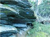
 | Dom pod Storžičem - Tolsti vrh
Tolsti vrh, located to the west of Storžič, is also the highest peak of the Kriška Gora, a mountain range rising steeply above the central Gorenj...
2 h |
 | Bistriška planina - Dobrča
Dobrča is a 1634 m high mountain located between Begunje and Tržič. From the top, where the registration box with the stamp is located, we can se...
1 h 30 min |
 | Črni Kal - Blegoš (by road, via hut)
Blegoš is a 1562 m high mountain located between Selška and Poljane Sora. From the grassy summit, on which there is a stamp and a registration bo...
1 h 30 min |
 | Črni kal - Blegoš (via Prva ravan)
Blegoš is a 1562 m high mountain located between Selška and Poljane Sora. From the grassy summit, on which there is a stamp and a registration bo...
1 h 20 min |
 | Hunting cottage (Davča) - Porezen
Porezen is a 1630 m high mountain located between Davča and Baška Grapa. From the top, where a large NOB monument stands, we have a beautiful vie...
1 h 45 min |
| Cimprovka (Davča) - Porezen (by road)
Porezen is a 1630 m high mountain located between Davča and Baška Grapa. From the top, where a large NOB monument stands, we have a beautiful vie...
2 h 15 min |
 | Podhočar - Porezen
Porezen is a 1630 m high mountain located between Davča and Baška Grapa. From the top, where a large NOB monument stands, we have a beautiful vie...
1 h 50 min |
 | Volovljek - Kranjska reber
Kranjska reber or Peak Kašna planina (1435 m) is a volcanic mountain. From the top, where the registration box with the stamp is located, we have...
1 h 20 min |
 | Črnivec - Kranjska reber
Kranjska reber or Peak Kašna planina (1435 m) is a volcanic mountain. From the top, where the registration box with the stamp is located, we have...
1 h 30 min |
 | Korensko sedlo - Ofen/Peč
Peč (also Tromeja), in Italian Monte Forno and in German Dreiländereck or Ofen, is a 1508 m high peak located on the tri-border between Slovenia,...
2 h |
 | Korensko sedlo - Ofen/Peč (on marked path)
Peč (also Tromeja), in Italian Monte Forno and in German Dreiländereck or Ofen, is a 1508 m high peak located on the tri-border between Slovenia,...
2 h |
 | Dom pod Storžičem - Bela peč
The mountain, which is known mainly by climbers, is located north of Storžič on the slopes of Konjščice. From the top there is a beautiful view o...
2 h |
| Dom pod Storžičem - Bela peč (via Javorniški preval)
The mountain, which is known mainly by climbers, is located north of Storžič on the slopes of Konjščice. From the top there is a beautiful view o...
2 h 5 min |
 | Na kopiš - Bela peč (via Spodnja and Zgornja Konjščica)
The mountain, which is known mainly by climbers, is located north of Storžič on the slopes of Konjščice. From the top there is a beautiful view o...
2 h |
 | Leška gmajna - Lepenatka
Lepenatka is a grassy peak located south of the 1557 m high Rogatec. From the top, which has a registration box and a stamp, we have a beautiful ...
1 h 15 min |
 | Javorje - Stari vrh (via Koča na Starem vrhu)
Stari vrh is a 1217 m high mountain located above the ski resort of the same name. There is no view from the summit itself due to the forest, but...
1 h 35 min |
 | Javorje - Stari vrh (via Prehodi)
Stari vrh is a 1217 m high mountain located above the ski resort of the same name. There is no view from the summit itself due to the forest, but...
1 h 30 min |
 | Zgornja Sorica - Dravh
Dravh is a 1547 m high peak located between Sorica and Soriška mountain pasture. From the uncultivated summit, we have a beautiful view of Škofje...
1 h 30 min |
 | Hunting cottage Vojkovo - Vojkova koča na Nanosu
Vojkova koča is located on the southern edge of the Nanoše plateau, close to Pleše, a peak that is clearly visible from the motorway. From the hu...
1 h 45 min |
 | Furlanovo zavetišče pri Abramu - Vojkova koča na Nanosu
Vojkova koča is located on the southern edge of the Nanoše plateau, close to Pleše, a peak that is clearly visible from the motorway. From the hu...
2 h |
 | Kramarica - Smrekovec (via Bukov stan)
Smrekovec is a volcanic mountain on the eastern edge of the Smrekov Mountains. The extensive grassy summit, on which stands a pyramid with a regi...
1 h 30 min |
| Kramarica - Smrekovec (by road)
Smrekovec is a volcanic mountain on the eastern edge of the Smrekov Mountains. The extensive grassy summit, on which stands a pyramid with a regi...
1 h 30 min |
 | Predmeja - Kucelj na Čavnu
Kucelj is located on the southern slopes of Trnovo Forest, north-west of the Vipava valley. From the uncultivated summit on which the cross stand...
2 h |
| Predmeja (tunnels) - Kucelj na Čavnu (via Koča na Čavnu)
Kucelj is located on the southern slopes of Trnovo Forest, north-west of the Vipava valley. From the uncultivated summit on which the cross stand...
2 h 15 min |
 | Krnica - Kucelj na Čavnu (via Veliki Rob)
Kucelj is located on the southern slopes of Trnovo Forest, north-west of the Vipava valley. From the uncultivated summit on which the cross stand...
1 h 40 min |
 | Predmeja - Mali Modrasovec
Mali Modrasovec is a peak north of the house on Čavno in the Trnovo forest. On the top, surrounded by wods, there is a small house and a control ...
1 h 25 min |
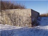 | Predmeja - Veliki Modrasovec (by road)
Veliki Modrasovec is located in the southern part of the Trnovo Forest near Predmeja. On the top of the hill is an old military building which yo...
1 h 20 min |
 | Predmeja - Veliki Modrasovec
Veliki Modrasovec is located in the southern part of the Trnovo Forest near Predmeja. On the top of the hill is an old military building which yo...
1 h 35 min |
| Predmeja (tunnels) - Veliki Modrasovec
Veliki Modrasovec is located in the southern part of the Trnovo Forest near Predmeja. On the top of the hill is an old military building which yo...
1 h 50 min |
 | Predmeja - Mali Golak
Mali Golak is the highest of the Golaks. It was named not because it was the smallest but because it had the smallest mountain pasture. On the ma...
2 h |
 | Mala Lazna - Mali Golak
Mali Golak is the highest of the Golaks. It was named not because it was the smallest but because it had the smallest mountain pasture. On the ma...
1 h 25 min |
 | Škrbina - Mali Golak
Mali Golak is the highest of the Golaks. It was named not because it was the smallest but because it had the smallest mountain pasture. On the ma...
2 h |
 | Kozarnice - Srednji Golak (via Mali Golak)
Srednji Golak is located between Mali and Veliki Golak on the plateau of the Trnovo Forest above Predmeja. The summit is covered with dwarf pines...
1 h 50 min |
 | Lokve - Poldanovec
Poldanovec is located in Govce on the northern edge of Trnovo plateau. Govci are quickly rising above Gorenje Trebuše valley. Poldanovec is not t...
1 h 30 min |
 | Turški klanec - Mrzovec
Mrzovec is the most expressing peak in heart of Trnovo plateau. His position offers us great view, but is also limited with high trees. Thats why...
1 h 30 min |
 | Grda draga - Mali Snežnik
Mali Snežnik is a peak on the west ridge of Snežnika. Vrh, which is covered with dwarf pines, has a fine view of the neighbouring Veliki Snežnik ...
1 h 30 min |
| Sviščaki - Mali Snežnik
Mali Snežnik is a peak on the west ridge of Snežnika. Vrh, which is covered with dwarf pines, has a fine view of the neighbouring Veliki Snežnik ...
1 h 50 min |
 | Dom na Paškem Kozjaku - Basališče (Paški Kozjak)
Basališče is the highest peak of Paško Kozjak. There is a bench and a registration box at the top. Due to the forest, there is no view....
2 h |
 | St. John the Baptist on Ojstrica - Huhnerkogel/Košenjak
Huhnerkogel lies north of Dravograd and the River Drava on the border with neighbouring Austria. Huhnerkogel is accessible on foot or by car from...
1 h 30 min |
 | St. John the Baptist on Ojstrica - Huhnerkogel/Košenjak (via Bivak Piramida)
Huhnerkogel lies north of Dravograd and the River Drava on the border with neighbouring Austria. Huhnerkogel is accessible on foot or by car from...
2 h |
 | Jezero Sobote / Stausee Soboth - Huhnerkogel/Košenjak (po označeni poti)
Huhnerkogel lies north of Dravograd and the River Drava on the border with neighbouring Austria. Huhnerkogel is accessible on foot or by car from...
2 h |
 | Avsa - Mrzli vrh (on Matajur) (old path)
Mrzli vrh is a 1358-metre high peak located in the Matajur Mountains. From the top, where there is a viewing platform and a registration box with...
1 h 25 min |
 | Plajberški graben / Bleiberger Graben - Sinacher Gupf / Psinski vrh
Sinacher Gupf (on maps we mostly see the name Psinski vrh) / Sinacher Gupf is a peak located north of the main chain Karawanks, more precisely no...
1 h 35 min |
 | Strugarjach / Strugarje - Sinacher Gupf / Psinski vrh
Sinacher Gupf (on maps we mostly see the name Psinski vrh) / Sinacher Gupf is a peak located north of the main chain Karawanks, more precisely no...
1 h 30 min |
 | Planinski dom Vrhe - Črni vrh (Čemšeniška planina)
Črni vrh is the highest peak of Čemšeniška mountain pasture and with a height of 1204 m it is the second highest peak in the Posavje - Zasavje hi...
1 h 30 min |
 | Ljubelj - Polna peč
Polna peč, also marked on maps as Ravna peč, is located above the Ljubljana Tunnel. From the top, which is somewhat precipitous, there is a beaut...
1 h 15 min |
 | Bučan - Polna peč
Polna peč, also marked on maps as Ravna peč, is located above the Ljubljana Tunnel. From the top, which is somewhat precipitous, there is a beaut...
1 h 30 min |
 | Kampelc - Javornik above Črni vrh
Javornik is a forested peak located southeast of Črnji Vrho. In 1972, a lookout tower was erected on the summit, which reaches above the treetops...
2 h 15 min |
 | Repna dolina - Javornik above Črni vrh
Javornik is a forested peak located southeast of Črnji Vrho. In 1972, a lookout tower was erected on the summit, which reaches above the treetops...
1 h 45 min |
 | Vodice (Mali Školj) - Javornik above Črni vrh
Javornik is a forested peak located southeast of Črnji Vrho. In 1972, a lookout tower was erected on the summit, which reaches above the treetops...
1 h 30 min |
 | Kalce - Veliki Javornik (Javorniki)
Veliki Javornik is a 1,268-metre-high peak in the forested hills called the Javorniki. The vast forests of the Javorniki stretch from Postojna to...
1 h 30 min |
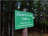 | Koča na Šumiku - Žigartov vrh
At 1346m, Žigartov vrh is the highest peak in the eastern part of Pohorje. An "observation" tower used to stand on the summit, but was erected on...
1 h 55 min |
 | Pohorje cable car - Žigartov vrh (via Razglednik)
At 1346m, Žigartov vrh is the highest peak in the eastern part of Pohorje. An "observation" tower used to stand on the summit, but was erected on...
2 h 15 min |
 | Platak - Snježnik (via grlo)
Snježnik is a scenic mountain in the western part of Gorski Kotar. The summit offers a beautiful view of the Kvarner islands, the Gulf of Reška, ...
1 h 30 min |
| Platak - Snježnik (via crest)
Snježnik is a scenic mountain in the western part of Gorski Kotar. The summit offers a beautiful view of the Kvarner islands, the Gulf of Reška, ...
1 h 30 min |
 | Bistriška planina - Šentanski vrh
Šentanski vrh, located in the Dobrča mountain range, only 5 minutes away from the main peak, offers a beautiful view of the central Karawanks, th...
1 h 35 min |
 | Preval Vrh Ravni - Kojca
Kojca is a scenic peak rising south of Baška Grape. The hay pile on the top offers a beautiful view of the Lower Bohinj Mountains, the Škofjelošk...
1 h 20 min |
 | Zakojca - Kojca
Kojca is a scenic peak rising south of Baška Grape. The hay pile on the top offers a beautiful view of the Lower Bohinj Mountains, the Škofjelošk...
1 h 45 min |
 | Koča na Starem vrhu - Mladi vrh (via Stari vrh)
Mladi vrh is the senior neighbour of the better known Stari vrh, from which it is separated by a saddle. The top is covered with a sparse beech f...
1 h 40 min |
 | Črni Kal - Mladi vrh (via Koprivnik)
Mladi vrh is the senior neighbour of the better known Stari vrh, from which it is separated by a saddle. The top is covered with a sparse beech f...
2 h 15 min |
| Preval - Mladi vrh
Mladi vrh is the senior neighbour of the better known Stari vrh, from which it is separated by a saddle. The top is covered with a sparse beech f...
2 h |
 | Podkraj - Križna gora (Hrušica) (gentle path)
Križna gora is a 1162 m high peak located north of the village of Podkraj. From the top of the lookout tower, you can enjoy a beautiful view over...
1 h 20 min |
 | Podkraj - Sveti Duh (Hrušica)
The Sveti Duh Church is located just a few metres below the eponymous peak on the slopes of the forested Hrušice, a mountain range between Col, L...
1 h 15 min |
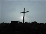
 | Koča na planini Stador - Kobilja glava
Kobilja glava is a 1475 m high peak located east of Tolmin. From the top with a cross, we have a beautiful view of the Krn, the Lower Bohinj Moun...
1 h 15 min |
 | Korensko sedlo - Kamnati vrh/Steinberg (by road)
Kamnati vrh is a 1621 m high mountain located north of Kranjska Gora. The grassy summit, on which the bench is located, is not visible due to the...
2 h |
 | Ledine - Gladki vrh (Ratitovec) (via planina Klom)
Gladki vrh is the most visited peak in the Ratitovec mountain range with an altitude of 1667 m. The uncultivated summit, on which the viewing pla...
1 h 55 min |
 | Torka - Gladki vrh (Ratitovec)
Gladki vrh is the most visited peak in the Ratitovec mountain range with an altitude of 1667 m. The uncultivated summit, on which the viewing pla...
1 h 20 min |
 | Torka - Altemaver (Ratitovec)
Altemaver is the highest peak of Ratitovec at 1678 m. The grassy peak offers a beautiful view of Julian Alps, Jelovica, Karawanks, Kamnik Savinja...
1 h 35 min |
 | Koprivna (Kumer) - Topitza
Topitza, or Topitza in German, is a 1649 m high peak located northeast of Železna Kapla. From the summit, on which the cross stands, we have a be...
2 h 10 min |
| Podkraj - Srednja gora (Hrušica) (east path)
Srednja gora is a 1275 m high peak located in the central part of the forested Hrušice. The peak is covered with forest, and just a few minutes w...
1 h 30 min |
| Podkraj - Srednja gora (Hrušica) (west path)
Srednja gora is a 1275 m high peak located in the central part of the forested Hrušice. The peak is covered with forest, and just a few minutes w...
1 h 45 min |
 | Podkraj - Streliški vrh (Hrušica) (east path)
Streliški vrh is a 1266 m high mountain located in the central part of the forested Hrušice. From the top, which is partly covered with forest, w...
1 h 30 min |
| Podkraj - Streliški vrh (Hrušica) (west path)
Streliški vrh is a 1266 m high mountain located in the central part of the forested Hrušice. From the top, which is partly covered with forest, w...
1 h 20 min |
 | Ravne - Cerk
At 1192 m, Cerk is the highest peak of Borovška Gora, a mountain range located between the Kolpa River valley and Goteniškje Snežnik. From the to...
1 h 30 min |
 | Solarji - Nagnoj
At 1193 m, Nagnoj is the second highest peak of the Kolovrat, a mountain range located between Tolmin and Venetian Slovenia. From the top, where ...
1 h 40 min |
 | Soriška peč - Žbajnek
Žbajnek is a 1538 m high peak located west of Ratitovec. The grassy peak, surrounded by a rare forest, offers a beautiful view of Julian Alps, Ka...
1 h 30 min |
 | Dom na Paškem Kozjaku - Štrukljev vrh
Štrukljev vrh is one of the three main peaks of Paški Kozjak, a 10 km long, narrow and very steep limestone mountain range between the Paka and H...
1 h 30 min |
 | Avsa - Srednji vrh (on Matajur) (old path)
Srednji vrh is a 1320-metre high grassy peak located in the Matajur mountain range. The summit, which is a take-off point for paragliders, offers...
1 h 20 min |
 | St. John the Baptist on Ojstrica - Kozji vrh (at Košenjak)
Kozji vrh is a 1383-metre-high peak located above Pernice, and its height makes it the highest peak in the municipality of Muta....
1 h 35 min |
 | Chortata - Egklouvi road - Stavrota (Lefkada)
Stavrota or Elati mountain is a 1182 m high mountain on the Greek island Lefkada. The island, which lies in Ionian sea, is also known as Lefkas o...
1 h 50 min |
 | Koča na Šumiku - Veliki vrh (on Pohorje)
Veliki vrh is a 1344-metre-high peak located above the RTC Jakec - Trije kralji ski resort. The highest point of the peak is located in the fores...
2 h |
 | Teichalm (Teichalmsee) - Rote Wand (spodnja pot)
Rote Wand is a 1505 m high mountain in the Graz mountain range in Styria, Austria. It is named "Rote Wand" (red wall) after the southeast-facing ...
2 h 15 min |
| Teichalm (Teichalmsee) - Rote Wand (zgornja pot)
Rote Wand is a 1505 m high mountain in the Graz mountain range in Styria, Austria. It is named "Rote Wand" (red wall) after the southeast-facing ...
2 h 15 min |
 | Mönichkirchen - Steinerne Stiege
Steinerne Stiege is a less prominent peak in the Wechsell mountain range....
1 h 35 min |
 | St. Vinzenz (St. Vinzenz) - Dreieckkogel
...
1 h 35 min |
 | Planinski dom Orlove stine - Svilaja (mimo Umaca)
...
2 h |
 | Malovan - Čardak (Tremzina)
...
2 h |
 | Nechnitz - Gerlerkogel (čez Gschaidberg)
...
2 h 15 min |
 | Teichalm (Angerwirt) - Osser
...
1 h 20 min |
 | Teichalm (Harrerhütte) - Osser
...
1 h 35 min |
 | Straßegg - Hochschlag
...
1 h 45 min |