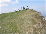
 | Tomčeva koča na Poljški planini - Begunjščica
Begunjščica is a mountain range in Karawanks east of Stol. The highest peak is Veliki vrh, which at over 2000m offers a beautiful view of central...
2 h 50 min |
 | Planina Jezerca - Veliki Zvoh (via Dom na Krvavcu)
Veliki Zvoh is the highest point of the Krvavec ski resort. The cable car does not quite reach the top, but it is only a few metres short of the ...
1 h 40 min |
 | Mrzli studenec - Veliki vrh (Košuta)
Veliki vrh, with a height of 2088 m, is the westernmost two-thousander in the longest Slovenian ridge - the Košuta. From the summit, where there ...
2 h 15 min |
 | Rudno polje - Viševnik
Viševnik is a 2050 m high mountain rising north-west of Rudno polje on Pokljuka. From the top of the peak where the stamp is located, you have a ...
2 h |
 | Pri Rupah - Mrežce (direct way)
Mrežce is a prominent peak near Lipanski vrh which can be seen on the other side of the ravine between the two peaks. As the slopes towards Poklj...
1 h 40 min |
 | Planina Zajavornik - Mrežce
Mrežce is a prominent peak near Lipanski vrh which can be seen on the other side of the ravine between the two peaks. As the slopes towards Poklj...
1 h 55 min |
| Šport hotel - Mrežce
Mrežce is a prominent peak near Lipanski vrh which can be seen on the other side of the ravine between the two peaks. As the slopes towards Poklj...
2 h 40 min |
 | Planina Zajavornik - Mrežce (gentle path)
Mrežce is a prominent peak near Lipanski vrh which can be seen on the other side of the ravine between the two peaks. As the slopes towards Poklj...
2 h |
 | Pri Rupah - Lipanski vrh
The summit is located above Blejska koča on the mountain pasture of Lipanca. From the summit, which descends precipitously towards the Krma valle...
1 h 45 min |
 | Medvedova konta - Debela peč
Debela peč is a 2014 m high mountain that rises steeply above the Krma valley on one side and descends gently towards the vast Pokljuka forests o...
2 h 15 min |
 | Pri Rupah - Debela peč
Debela peč is a 2014 m high mountain that rises steeply above the Krma valley on one side and descends gently towards the vast Pokljuka forests o...
2 h 15 min |
| Strmec - Debela peč (via Spodnja Brda)
Debela peč is a 2014 m high mountain that rises steeply above the Krma valley on one side and descends gently towards the vast Pokljuka forests o...
2 h 45 min |
| Planina Zajavornik - Debela peč
Debela peč is a 2014 m high mountain that rises steeply above the Krma valley on one side and descends gently towards the vast Pokljuka forests o...
2 h 30 min |
| Strmec - Debela peč
Debela peč is a 2014 m high mountain that rises steeply above the Krma valley on one side and descends gently towards the vast Pokljuka forests o...
2 h 30 min |
 | Strmec - Debela peč (old path)
Debela peč is a 2014 m high mountain that rises steeply above the Krma valley on one side and descends gently towards the vast Pokljuka forests o...
2 h 15 min |
 | Planina Loka - Velika Raduha
At 2062 m, Velika Raduha is the highest peak of Raduha, a mountain range rising steeply to the east of Robanov Kot. From the summit, which has a ...
1 h 55 min |
 | Snežna jama - Velika Raduha
At 2062 m, Velika Raduha is the highest peak of Raduha, a mountain range rising steeply to the east of Robanov Kot. From the summit, which has a ...
1 h 45 min |
 | Bukovnik - Velika Raduha (via Durce)
At 2062 m, Velika Raduha is the highest peak of Raduha, a mountain range rising steeply to the east of Robanov Kot. From the summit, which has a ...
2 h 50 min |
| Planina Vodol - Velika Raduha
At 2062 m, Velika Raduha is the highest peak of Raduha, a mountain range rising steeply to the east of Robanov Kot. From the summit, which has a ...
2 h 40 min |
 | Medvedova konta - Brda (west path)
Brda is a scenic peak located between Pokljuka and Krma. From the top, where a stamp is attached to a metal pole, we have a beautiful view toward...
2 h |
| Medvedova konta - Brda (east path)
Brda is a scenic peak located between Pokljuka and Krma. From the top, where a stamp is attached to a metal pole, we have a beautiful view toward...
2 h |
 | Planina Zajavornik - Brda (east path)
Brda is a scenic peak located between Pokljuka and Krma. From the top, where a stamp is attached to a metal pole, we have a beautiful view toward...
2 h 15 min |
 | Pri Rupah - Brda (west path)
Brda is a scenic peak located between Pokljuka and Krma. From the top, where a stamp is attached to a metal pole, we have a beautiful view toward...
2 h |
 | Pri Rupah - Brda (east path)
Brda is a scenic peak located between Pokljuka and Krma. From the top, where a stamp is attached to a metal pole, we have a beautiful view toward...
2 h |
 | Valvasorjev dom - Prešernova koča na Stolu (Žirovniška way)
Prešernova koča na Stolu, is located just a few metres below the summit of the 2198 m high Mali Stol. From the hut or the nearby Mali Stol, we ha...
2 h 45 min |
 | Kriška planina - Vrh Korena (via Planina Koren)
Vrh Korena is located between Zvoh and Kalški greben near the Krvavški ski slopes. From the top there is a beautiful view towards the highest pea...
2 h 15 min |
| Dom na Gospincu - Vrh Korena (via Dolga njiva)
Vrh Korena is located between Zvoh and Kalški greben near the Krvavški ski slopes. From the top there is a beautiful view towards the highest pea...
2 h 25 min |
| Planina Jezerca - Vrh Korena (via planina Koren)
Vrh Korena is located between Zvoh and Kalški greben near the Krvavški ski slopes. From the top there is a beautiful view towards the highest pea...
2 h 30 min |
 | Kriška planina - Kompotela
Kompotela is a peak near Mokrica and the summit of Koren. The grass and dwarf pines covered peak has a beautiful view towards Grintovec, Skuta, B...
2 h 15 min |
| Planina Jezerca - Kompotela
Kompotela is a peak near Mokrica and the summit of Koren. The grass and dwarf pines covered peak has a beautiful view towards Grintovec, Skuta, B...
2 h 30 min |
 | Medvedova konta - Debeli vrh above Lipanca
Debeli vrh is a 1962 m high mountain located in a ridge of mountains rising steeply above the Krma valley. From the top, where a stamp is attache...
2 h 15 min |
| Rudno polje - Debeli vrh above Lipanca (via Kačji rob)
Debeli vrh is a 1962 m high mountain located in a ridge of mountains rising steeply above the Krma valley. From the top, where a stamp is attache...
2 h 45 min |
 | Planina Zajavornik - Debeli vrh above Lipanca
Debeli vrh is a 1962 m high mountain located in a ridge of mountains rising steeply above the Krma valley. From the top, where a stamp is attache...
2 h 30 min |
 | Planina Podvežak - Veliki vrh (Veža) (via Prag)
Velika vrh is a 2110 m high mountain located in the central part of the Dleskovška plateau. From the top of the peak, where there are two registr...
2 h 20 min |
 | Planina Ravne - Veliki vrh (Veža) (via Zelene trate)
Velika vrh is a 2110 m high mountain located in the central part of the Dleskovška plateau. From the top of the peak, where there are two registr...
2 h 15 min |
| Planina Ravne - Veliki vrh (Veža) (via Dolga trata)
Velika vrh is a 2110 m high mountain located in the central part of the Dleskovška plateau. From the top of the peak, where there are two registr...
2 h 30 min |
| Kraljev dol - Veliki vrh (Veža) (via Planina Vodole)
Velika vrh is a 2110 m high mountain located in the central part of the Dleskovška plateau. From the top of the peak, where there are two registr...
2 h 35 min |
 | Eisenkappler Hutte - Hochobir (Ojstrc)
Hochobir (Hochobir) is the highest peak of a small mountain range called Obir. It is located west of Železna Kapla (Eisenkappel) on the Austrian ...
1 h 35 min |
 | Rifugio Nordio - Osternig (Ojstrnik) (direct way)
Osternig) is the easternmost peak in Carnic Alps, exceeding 2000m. It is located on the border between Austria and Itali, near Trbiž (Tarvisio). ...
2 h 10 min |
| Rifugio Nordio - Osternig (Ojstrnik) (via Lom)
Osternig) is the easternmost peak in Carnic Alps, exceeding 2000m. It is located on the border between Austria and Itali, near Trbiž (Tarvisio). ...
2 h 15 min |
| Rifugio Nordio - Osternig (Ojstrnik) (via Sella Pleccia)
Osternig) is the easternmost peak in Carnic Alps, exceeding 2000m. It is located on the border between Austria and Itali, near Trbiž (Tarvisio). ...
2 h 10 min |
 | Johannsenruhe - Ovčji vrh (Kozjak) / Geissberg (Kosiak) (southwest path)
Ovčji vrh or Kozjak, or Geissberg or Kosiak in German, is a 2024 m high peak located north of the main ridge of the Karavanke Mountains. The peak...
2 h 30 min |
| Trate / Johannsenruhe - Ovčji vrh (Kozjak) / Geissberg (Kosiak) (southeast path)
Ovčji vrh or Kozjak, or Geissberg or Kosiak in German, is a 2024 m high peak located north of the main ridge of the Karavanke Mountains. The peak...
2 h 35 min |
 | Planina Kuk - Vogel (direct way)
When you hear the name Vogel, many people first think of the Vogel ski resort, which is located near the peak of the same name. From the north si...
2 h 45 min |
 | Waldheim Hütte - Zirbitzkogel (Seetal Alps) (direct way)
At 2396m, Zirbitzkogel is the highest peak in the Seetaler Alps. The summit, on which stands a cross and a viewing platform, offers a beautiful v...
2 h 2 min |
| Winterleiten parking - Zirbitzkogel (Seetal Alps)
At 2396m, Zirbitzkogel is the highest peak in the Seetaler Alps. The summit, on which stands a cross and a viewing platform, offers a beautiful v...
2 h 17 min |
 | Tonnerhütte - Zirbitzkogel (Seetal Alps)
At 2396m, Zirbitzkogel is the highest peak in the Seetaler Alps. The summit, on which stands a cross and a viewing platform, offers a beautiful v...
2 h 32 min |
 | Waldheim Hütte - Fuchskogel (Seetal Alps) (via Wildsee)
Fuchskogel is a peak south of Zirbitzkogel in the Seetaler Alps. The summit is vast and mostly covered with grass. More precisely, the summit is ...
2 h 30 min |
| Tonnerhütte - Fuchskogel (Seetal Alps)
Fuchskogel is a peak south of Zirbitzkogel in the Seetaler Alps. The summit is vast and mostly covered with grass. More precisely, the summit is ...
2 h 20 min |
 | Waldheim Hütte - Scharfes Eck (Seetal Alps) (direct way)
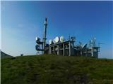
Scharfes Eck is the peak on which the Austrian meteorological radar station stands. The unpopular peak offers a beautiful view of the neighbourin...
2 h 30 min |
| Winterleiten parking - Scharfes Eck (Seetal Alps)
Scharfes Eck is the peak on which the Austrian meteorological radar station stands. The unpopular peak offers a beautiful view of the neighbourin...
2 h |
 | Walischeben - Weißenstein (Packalpe)
Weissenstein is a grassy mountain interspersed with wire fences. From its inconspicuous summit there is a fine view of the neighbouring Ameringko...
1 h 45 min |
 | Salzstiegelhaus - Weißenstein (Packalpe)
Weissenstein is a grassy mountain interspersed with wire fences. From its inconspicuous summit there is a fine view of the neighbouring Ameringko...
2 h 20 min |
 | Walischeben - Ameringkogel (Packalpe)
Ameringkogel is a grassy peak on which a cross is placed and on which a registration box is placed. At 2187m, it is also the highest peak in the ...
1 h 55 min |
| Salzstiegelhaus - Ameringkogel (Packalpe)
Ameringkogel is a grassy peak on which a cross is placed and on which a registration box is placed. At 2187m, it is also the highest peak in the ...
2 h 30 min |
 | Walischeben - Großenberg (Packalpe) (via Ameringkogel)
Großenberg is the northernmost of the two-thousanders in the Packalp chain. The vast grassy summit on which the triple cross stands offers a beau...
2 h 25 min |
| Walischeben - Großenberg (Packalpe)
Großenberg is the northernmost of the two-thousanders in the Packalp chain. The vast grassy summit on which the triple cross stands offers a beau...
2 h 20 min |
| Salzstiegelhaus - Großenberg (Packalpe)
Großenberg is the northernmost of the two-thousanders in the Packalp chain. The vast grassy summit on which the triple cross stands offers a beau...
2 h 55 min |
 | Walischeben - Hofalmkogel (Packalpe) (via Weissenstein)
Hofalmkogel is a less prominent peak in the ridge from Großenberg to Speikkogel. The summit is broad and mostly covered with grass. From the top ...
2 h 5 min |
 | Salzstiegelhaus - Hofalmkogel (Packalpe)
Hofalmkogel is a less prominent peak in the ridge from Großenberg to Speikkogel. The summit is broad and mostly covered with grass. From the top ...
1 h 50 min |
 | Jakobe - Petzen (Kordeschkopf) (Peca (Kordeževa glava)) (easy path)
Kordeževa glava, better known as Peca is the highest summit in the mountain chain Peca. It is located on the border with Austria above Mežiška do...
2 h 15 min |
 | Zadnji travnik - Govca (Olševa)
Govca is the highest peak of the Olševa, a mountain range rising above Koprivna, Solčava and Remschenik (Remschenik / Remschenig is a valley on t...
1 h 45 min |
 | Planina Ravne - Velika Zelenica (via Zelene trate)
Velika Zelenica is the highest peak of the Dleskovská Plateau and the view is accordingly. The most beautiful is the nearby Ojstrica, below which...
2 h 15 min |
 | Planina Podvežak - Velika Zelenica (via Prag)
Velika Zelenica is the highest peak of the Dleskovská Plateau and the view is accordingly. The most beautiful is the nearby Ojstrica, below which...
2 h 30 min |
| Planina Ravne - Velika Zelenica (via Dolga trata)
Velika Zelenica is the highest peak of the Dleskovská Plateau and the view is accordingly. The most beautiful is the nearby Ojstrica, below which...
2 h 30 min |
 | Dolinza Alm/Planina Dolnica - Starhand
Starhand is a scenic peak on the eastern part of Carnic Alps near the better known Ojstrnik. From the top you can enjoy a beautiful view of the J...
1 h 40 min |
| Koutschitz Alm/Kočiška planina - Starhand (by road)
Starhand is a scenic peak on the eastern part of Carnic Alps near the better known Ojstrnik. From the top you can enjoy a beautiful view of the J...
2 h 15 min |
 | Waldrast - Großer Speikkogel (Koralpe)
At 2140m, Großer Speikkogel is the highest peak of the Golice/Koralpe, a mountain range located east of Wolfsberg. From the top, where a cross an...
2 h |
 | Waldrast - Großer Speikkogel (Koralpe) (ob robu planote Großes Kar)
At 2140m, Großer Speikkogel is the highest peak of the Golice/Koralpe, a mountain range located east of Wolfsberg. From the top, where a cross an...
2 h 45 min |
 | Lading - Speikkogel (Saualpe)
Speikkogel is an unmarked peak in the long mountain pasture ridge of the Sow. The expansive summit offers a fine view of the nearby Großer Sauofe...
2 h 25 min |
 | Lading - Ladinger Spitze (Saualpe) (via Wolfsberger Hütte)
Ladinger Spitze, or Ladinger Spitze in German, is the highest peak of the mountain pasture Sow/Saualpe at 2079m. From the summit on which the cro...
2 h 45 min |
 | Heidi Alm - Klomnock
Klomnock is the house mountain of the Nockalmstraße Alpine road, which leads to the Schiestelscharte Pass (2024m). From the summit on which the c...
2 h 15 min |
 | Turracher Höhe - Kaserhöhe
Kaserhöhe is a scenic peak located in Austrian Carinthia in the heart of the Krkonoše Alps. On the spacious peak, which is partly covered with gr...
2 h 20 min |
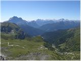 | Rifugio Bai de Dones - Rifugio Nuvolau (Trincee)
The Rifugio Nuvolau mountain hut is located on the peak of the same name, south-west of Cortina d'Ampezzo. From the top, in fine weather, you can...
2 h 50 min |
| Rifugio Bai de Dones - Rifugio Nuvolau (via Rifugio Cinque Torri)
The Rifugio Nuvolau mountain hut is located on the peak of the same name, south-west of Cortina d'Ampezzo. From the top, in fine weather, you can...
2 h 35 min |
 | Rifugio Tolazzi - Monte Floriz
Monte Floriz is a 2184m high grassy peak located south of the Marinelli hut. From the summit there is a very fine view of the Coglians group, and...
2 h 25 min |
 | Pri Rupah - Okroglež
Okroglež is a dwarf pines vegetated peak located between Debela peč and Brdy. From the summit, which has a stamp (without a registration book), w...
1 h 55 min |
 | Rudno polje - Okroglež
Okroglež is a dwarf pines vegetated peak located between Debela peč and Brdy. From the summit, which has a stamp (without a registration book), w...
2 h 55 min |
 | Bukovnik - Lanež
Lanež is a less distinct peak located in the eastern part of Raduha. The spacious peak offers a beautiful view of the nearby Mala Raduha, Olševa,...
2 h 20 min |
 | Koprein-Petzen - Wackendorfer Spitze
Wackendorfer Spitze is the northernmost two-thousander in the Pec mountain range. From this inconspicuous peak, in fine weather, we can enjoy a m...
2 h 30 min |
| Koprivna (Kumer) - Wackendorfer Spitze
Wackendorfer Spitze is the northernmost two-thousander in the Pec mountain range. From this inconspicuous peak, in fine weather, we can enjoy a m...
2 h 55 min |
 | Koprein-Petzen - Feistritzer Spitze
Feistritzer Spitze is a 2113 m high peak located on the Austrian side of Pec. From the top on which the cross stands, you have a beautiful view o...
2 h 30 min |
| Koprivna (Kumer) - Feistritzer Spitze (Austrian path)
Feistritzer Spitze is a 2113 m high peak located on the Austrian side of Pec. From the top on which the cross stands, you have a beautiful view o...
2 h 55 min |
 | Koprivna (Kumer) - Končnikov vrh (slovenska pot)
Končnikov vrh is a 2109 m high mountain located in the central part of Pec. The grassy peak offers a beautiful view along the Pec ridge and the m...
2 h 55 min |
 | Jakobe - Končnikov vrh (easy path)
Končnikov vrh is a 2109 m high mountain located in the central part of Pec. The grassy peak offers a beautiful view along the Pec ridge and the m...
2 h 45 min |
 | Volkzeinalm - Hochalmspitze (Villgraten)
Hochalmspitze is a 2797 m high peak located in the south-western part of High Tauern in the Villgraten mountain group. It is much less popular am...
2 h 45 min |
 | Planina Podvežak - Mala Ojstrica
Mala Ojstrica is a featureless peak located between Ojstrica, Molička mountain pasture and Korošica. From the top, where there is a registration ...
2 h 30 min |
 | Rifugio Selvapiana I.Lunelli - Croda Sora I Colesei / Arzalpenkopf (via Forcella Popera)
Croda Sora I Colesei or Arzalpenkopf in German is a 2321 m high mountain located on the eastern edge of the Sextens Dolomites / Dolomites di Sest...
2 h 30 min |
| Rifugio Selvapiana I.Lunelli - Croda Sora I Colesei / Arzalpenkopf (via Belvedere)
Croda Sora I Colesei or Arzalpenkopf in German is a 2321 m high mountain located on the eastern edge of the Sextens Dolomites / Dolomites di Sest...
2 h 30 min |
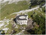 | Rifugio Selvapiana I.Lunelli - Belvedere (Creston Popera)
Belvedere is a 2125 m high peak located on the slopes of the Creston Popera ridge, a famous World War I battlefield. A stone semicircle is erecte...
1 h 40 min |
 | Heidi Alm - Mallnock
Mallnock is a 2226 m high peak located north of St. Oswald in the Krkonoše Alps. From the top with a cross, you can enjoy a beautiful view of the...
2 h 30 min |
 | Heidi Alm - Mallnock (via Klomnock)
Mallnock is a 2226 m high peak located north of St. Oswald in the Krkonoše Alps. From the top with a cross, you can enjoy a beautiful view of the...
2 h 45 min |
 | Rifugio Rio Gere - Rifugio Tondi
Chalet Rifugio Tondi is located a few metres below the summit of Monte Ciasadio, the highest point of the Faloria ski resort. The hut has a very ...
2 h 15 min |
 | Obertauern - Gamsleitenspitze
Gamsleitenspitze is a 2359 metre high mountain in the Radstadt Tauern mountain group. From the summit, which is located above the Obertauern ski ...
2 h |
 | Sadnighaus - Sadnig (direct way (path 150))
Sadnig or Hoher Sadnig is a relatively easily accessible and scenic mountain in the eponymous Sadniggruppe (German: Sadniggruppe), which is the s...
2 h 45 min |
 | Zadnji travnik - Obel kamen (Olševa)
Obel kamen is a 1911 m high peak located in the Olševa Ridge. On the summit there is a boundary stone marked RS XXII 1, the cross and the registr...
2 h 15 min |
 | Klippitztörl - Kienberg (Saualpe) (via Geierkogel)
Kienberg is a 2050 m high peak in the Svinja mountain pasture / Saualpe massif. The grassy summit offers a beautiful view over most of the Svinsk...
2 h 50 min |
 | Waldrast - Steinschneider (ob robu planote Großes Kar)
...
2 h 20 min |