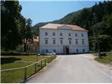
Studenice - Source of Topli (Studeniški) potok
Starting point: Studenice (260 m)
| Lat/Lon: | 46,2999°N 15,6138°E |
| |
Time of walking: 5 min
Difficulty: easy marked way
Altitude difference: 35 m
Altitude difference po putu: 35 m
Map: Posavsko hribovje Boč - Bohor 1:50.000
Recommended equipment (summer):
Recommended equipment (winter):
Views: 4.117
 | 1 person likes this post |
Access to the starting point:
a) From the route of Ljubljana, leave the motorway at Slovenske Konjice and drive through Žič, Loč and Zbelovo to the centre of Poljčany. In the centre, turn right in the direction of Studenice and after about three kilometres reach Studenicee, where you continue to the right over the bridge over the Dravinja River into the central part of the settlement. Park safely in front of the monastery complex.
b) From Maribor, leave the motorway at Slovenska Bistrica, where signs direct you to Poljčane. In the centre, turn left towards Studenice and after about three kilometres reach Studenice, where you continue right over the bridge over the Dravinja River into the central part of the settlement. Park safely in front of the monastery complex.
c) From the direction of Ptuj, Kidričevo via Ptujska gora, Majšperk and Makole, arrive at Studenice, where you continue left over the bridge over the Dravinja river into the central part of the settlement. Park safely in front of the monastery complex.
Path description:
After a short tour of the central part of Studenice, we continue to the left of the monastery complex by the parish. In the passageway/underpass between the churchyard and the Studenice wine-growers' association, continue up the cart track along the stone walls. The path to Studenice castle also branches off to the left, higher up and soon again to the left along the path is a small stream with water flowing in a wooden trough. Further along the path on the right, enter through the iron gates, the old nun's cemetery of the Dominican and Magdalene nuns who have marked the history of Studenice over the turbulent centuries. Further along the path, to the left, a stone/wooden well and the remains of the iron/concrete skeleton of a quarry. Somewhere the only "stranger", which somehow blended into the environment. A few more steps and the spring/springs of the stream are more or less rich in water. The world higher up is typically somewhere similar to a karst, limestone area and their water content depends on precipitation, melting snow. A few benches in an oasis of silence, peace and a small wooden footbridge for crossing the stream at higher water levels and this is also somewhere the goal of the short route, suitable for practically everyone.

Pictures:
 1
1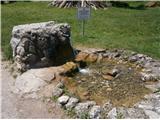 2
2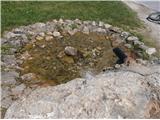 3
3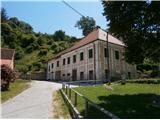 4
4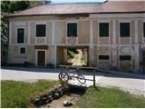 5
5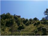 6
6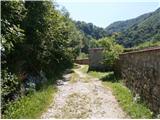 7
7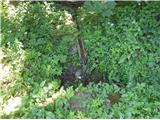 8
8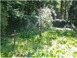 9
9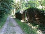 10
10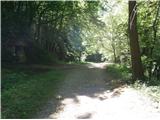 11
11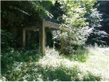 12
12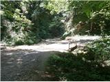 13
13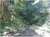 14
14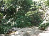 15
15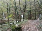 16
16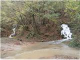 17
17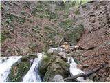 18
18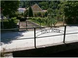 19
19
Discussion about the trail Studenice - Source of Topli (Studeniški) potok
|
| bruny6. 09. 2014 |
Do izvirov danes. Vodnatost zelo podobna kot je na slikah 16,17 in 18. Aktivni vsa četverica, tudi skrajno levi. Tretji in četrti kot ponavadi ob večji vodnatosti kalna, nekoliko rjava/blatna voda. V nadaljevanju danes visoko nad izvire v svet Boča in Plešivca, kjer se tvori to kar silovito vodovje...V okolici Formile izrazito ponikne v sistem podzemnih vod. Morda kej več v razmerah!?...
|
|
|
|
| bruny29. 03. 2015 |
Danes začetek in zaključek po opisani poti. Zelo živahno je bilo danes v Studenicah in ob tej poti. Nabiralci prvi ,,poljščine,,v letu - čemaža so nabirali zdravilno rastlino. Prav je tako, naj se živi z naravo čeprav nekoliko višje je čemaž še bolj izrazit...
|
|
|
|
| bruny23. 05. 2015 |
Višje v svet Boča po opisani poti danes popoldan in tudi sestop...Vodnatost izvirov močna po nekaj dnevnih izdatnih padavinah...izviri še nekoliko bolj vodnati kot na slikah 16,17 in 18. Lp
|
|
|
|
| bruny16. 01. 2016 |
Popoldan v eni od snežnih ploh, ki so se ,,podile,, po Boču in ob reki Dravinji kratka kolesarska do izvira Studeniškega/Toplega potoka in nazaj v Poljčane. Ob zaključku še kratek odsek ob potoku Bela med Zgornjimi Poljčanami in sotočjem z reko Dravinjo. Ja Boča je bilo danes zelo malo, nekaj več je bilo ob vodi, ki se v glavnem nabira ravno iz Boča v obeh potokih. Tudi nekaj snežne podlage je bilo za mini januarski snežni vtis... Izvir Studeniškega/Toplega potoka in nekaj malega ob potoku Bela pred sotočjem z Dravinjo, 16.01.2016Lp
|
|
|
|
| bruny18. 10. 2020 |
Boč je  nalilo in izvir  dokaj vodnat...
|
|
|
|
| bruny13. 12. 2020 |
Ob izviru/ih potoka višje v svet Boča. Vodnatost ,,močna,, ampak nekoliko manj kot na fotkah zgoraj...Višje danes še ni bila odjuga v pravem pomenu...
|
|
|
|
| bruny31. 12. 2020 |
Še vedno zelo vodnati, tudi danes...Taljenje snega višje in obilje padavin je pravi recept za ta svet podoben kraškemu...
|
|
|
|
| bruny30. 05. 2021 19:08:43 |
Danes. Vodnati so. Padavin je bilo v maju res veliko...
|
|
|
|
| bruny26. 12. 2021 18:36:36 |
Ob izviru danes višje v svet Boča. Nekaj centimetrov svežega snega in kar vodnati so...
|
|
|
|
| bruny8. 05. 2022 18:54:08 |
Izjemno vodnat izvir danes...Nočno deževje, tudi v v obliki neviht je bilo izdatno...
|
|
|
|
| bruny7. 06. 2022 13:18:38 |
Ni bil vodnat danes. Izsušen pa tudi ne...
|
|
|
|
| bruny18. 12. 2022 17:07:18 |
Ob izviru višje v svet Boča...Vodnat je bil!
|
|
|
|
| bruny16. 04. 2023 18:31:09 |
Danes popoldan...Vodnati in aktivni kar trije od štirih izvirov...
|
|
|
|
| jprim18. 04. 2023 11:55:06 |
@ bruny
No, pa smo bili spet na terenu, vendar tokrat ni bilo kolesarjev na poti, občasno je tudi pršilo.
V domu gužva, vendar ni bilo planinske druščine, temveč neka zabava. Tega dne sva srečala eno pohodnico.
Res pa je lepo za pogledat te izvire.
LP!
|
|
|
|
| bruny7. 01. 2024 14:35:05 |
Izjemno vodnati danes. Aktivni trije od štirih izvirov. Temperatura rahlo nad lediščem in še je rahlo deževalo...
|
|
|