Zgornje Radvanje - Mariborska koča
Starting point: Zgornje Radvanje (328 m)
| Lat/Lon: | 46,5339°N 15,5991°E |
| |
Time of walking: 2 h 15 min
Difficulty: easy unmarked way
Altitude difference: 758 m
Altitude difference po putu: 820 m
Map: Pohorje 1:50.000
Recommended equipment (summer):
Recommended equipment (winter):
Views: 33.672
 | 2 people like this post |
Access to the starting point:
The lower station of the Pohorje funicular is located on the south side of Maribor in Radvanje. It can be reached from several directions, and there are signposts or icons for Pohorje at major junctions in Maribor. If you arrive in Maribor by the southern entrance road, follow it through Hoče and turn left at the traffic lights at the shopping centres (direction Radvanje), continue along Lackova cesta and follow the signs. City bus No. 6 also runs to the station below.
Path description:
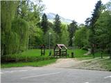
On the west side of the parking lot, cross the stream over a wooden bridge, then immediately follow the right-hand side around a small pond and turn into the woods. The stream on our left, from which we can also move away, but not too far, serves as an orientation guide for the correct direction along the many paths. Follow the path gently uphill through the forest until you reach a dirt road (* 15 min).
Turn right here and continue walking along the path, crossing the cable car route above us, spotting the spring of the stream on the right hand side of the road, and after a further 100 m turn right off the road into the woods, as indicated by the signpost for St. Bolfenk and Bellevue (* 5 min).
The path winds up through the beech forest and quickly leads to a wide paved path which turns right. Mountain bikers also use this trail for downhill riding, watch out for them, there are also jumps for them on the right hand side. At first the path becomes a slope and on the left edge you reach a small rise above the 4th pillar of the funicular, which you can see below you (* 10 min).
From here you have two options to continue:
*** You can continue straight ahead on the clearly visible path along the ski slope called Jonatanka, the path first descends a little and then starts to climb quite steeply and continuously until you reach a small forest which splits the hitherto single route into two Y-shaped sections. Go around the copse on the right-hand side and you will come to cart track, which crosses the route perpendicularly, with a stream running parallel to cart track. This route is slightly shorter than the other variant mentioned below, but it is also steeper and more boring.
*** Alternatively, turn left into the woods and follow the path up to the right. For orientation, use the recessed cart track on your left, which runs parallel to the path. At the point where the cart track ends, our path turns right. The path becomes more level and leads to a wider forest path, which you follow uphill until you emerge from the forest and join the path from the previous variant just below the fork (* 25min).
Choose one of the options to continue from the fork:
*** Cross cart track, go steeply uphill for a few minutes, then the path levels out a bit and from this point you can already see the top station of the funicular. Continue along the well-marked path through the clearing, followed by a very steep climb, and you will pass the former FIS stand to reach the top station of the funicular. This used to be the venue of women's skiing competitions, hence the name "old Fiska" among hikers for this part of the trail.
*** Alternatively, you can continue through the grove to the left up the cart track, reach the Jonatanka, which turns right uphill and left past the lower station of the Bolfenk ski lift. Following a clearly visible path through the meadow during a moderate ascent, follow the edge of the forest on your right, part of the path is also parallel to the cycle path (caution!), when the path becomes flatter and turns right, you will also see the upper station of the funicular. (* 20 min).
From the upper funicular station, follow the marked path from the western edge of the parking lot along a track parallel to the road, then turn right into the woods. When you reach the crossroads where the marked path turns left to Mariborska koča, we take the opportunity to continue straight ahead and up the meadow to the lookout tower ( * 20 min). Continue on the marked path through the woods to the west towards Areh, look out for the marked turnoff for Mariborska koča (* 5 min). Continue on the marked path through the woods towards Areh (* 5 min). Continue on the marked turnoff for Mariborska koča (* 5 min). Turn left down here and follow the otherwise few signs along a clearly visible path, just before the end you will reach an asphalt road, turn right at the junction and in a few minutes you will reach the finish (* 15 min).

Pictures:
 1
1 2
2 3
3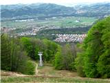 4
4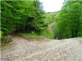 5
5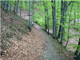 6
6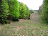 7
7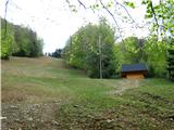 8
8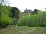 9
9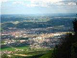 10
10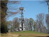 11
11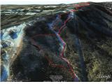 12
12
Discussion about the trail Zgornje Radvanje - Mariborska koča
|
| gasilec13. 10. 2009 |
V navedenem opisu je kot orientacijska točka naveden 4. steber Pohorske vzpenjače (slika št.4). Po porušitvi 8. stebra Pohorske vzpenjače (19.07.09)se je začela gradnja nove krožno-kabinske žičnice in sedaj so odstranjeni vsi nosilni stebri stare žičnice, tako da ima ta slika še samo "zgodovinsko" vrednost.Ko bo postavljen novi steber, bom sliko zamenjal.
Lep pozdrav!
|
|
|
|
| pohodnik3820. 11. 2011 |
Včeraj v soboto pobegnil iz te turobne megle po tej poti ki jo jaz opravim malce drugače...več pa si lahko ogledate na tej povezavi.
|
|
|
|
| pohodnik3824. 03. 2012 |
Danes 24.marca na lepo soboto pa sem ga ucvrl kar na Pohorje zaradi bolj slabe vremenske napovedi kar se je v drugi polovici dneva tudi potrdilo...pot brez problemov nikjer več snega tu in tam se pojavi kaka flehica in malo blata....nekaj slik pa na tej povezavi.
|
|
|
|
| potpodnoge3. 05. 2017 |
Uf, gledam letnico zadnjega zapisa. Če prideš z Gorenjske in želiš na Pohorje s tem, da začneš spodaj pri gondolski žičnici na Pohorje pa prideš pri zgornji postaji gondolske žičnice, kar je lepo videti na spletni kameri (druga slika kamere od zgoraj navzdol), a greš mimo Trikotne jase? Ta slika se mi zdaj pomladi zdi tako lepa, živo zelene barve, da ne bi smel iti mimo, brez, da bi se tu ustavil. Seveda je pa cilj zgornja gondolska postaja. Gornji opis, da grem mimo ribnika drži? Ali se začne nad hotelom Habakuk? Vem, da domačini to obvladate, saj je videti vsak dan izletnike, ampak za nas od malo dalj, pa ni vse skupaj tako enostavno, saj vemo, da je Pohorje širok pojem. Z avtom sem že bil zgoraj prelezel vse okoli do Mariborske koče, Areha in okolice, zdaj je pa treba to turo iz dna opraviti še peš, kar pa bo prvič. Hvala za odgovor.
|
|
|
|
| martin43. 05. 2017 |
Hoj,
drži, pot se začne desno od ribnika ( parkirišče, če prideš iz smeri Mb je desno), pot je shojena, strma. Ko prideš iz gozda, pod gondolo, samo rahlo desno, potem boš hodil cca 5-7 min po ravnini, kjer se začne prava strmina Jonatan proge, če želiš nadaljevati v smeri stare zelo strme Fis proge(videl boš stari kontr. stolp), se držiš bolj desno, pot te bo pripeljala do Zg. postaje gond.žičnice.
|
|
|
|
| dprapr5. 05. 2017 |
Če želiš mimo trikotne jase, je najboljša varijanta kar po smučarskih progah - od spodnje postaje vzpenjače po položni ali od hotela Arena po strmi, kjer prideš naravnost navzgor do jase.
Naprej lahko potem nadaljuješ kjerkoli. Ali po gozdnih stezicah, ki jih je veliko ali pa nadaljuješ po progi mimo koče Luka do zgornje postaje vzpenjače.
|
|
|
|
| potpodnoge11. 05. 2017 |
Hvala lepa obema za napotke.
|
|
|