Smolnik - Veliki Šumik waterfall (through valley of Lobnica - Holcarska pot)
Starting point: Smolnik (440 m)
Name of path: through valley of Lobnica - Holcarska pot
Time of walking: 2 h 10 min
Difficulty: difficult marked way
Altitude difference: 510 m
Altitude difference po putu: 510 m
Map: Pohorje 1:50.000
Recommended equipment (summer):
Recommended equipment (winter): ice axe, crampons
Views: 21.809
 | 4 people like this post |
Access to the starting point:
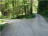
Smolnik is a settlement on the western side of Ruse, geographically stretching from Žigartovo vrh past Falski rybnik almost to Klopne vrh. From the centre of Ruse, head straight west along the asphalt road to Činžat odn. Lovrenc, passing the cemetery on the right. In Smolnik, before a typical railway viaduct, the road turns sharp right and then left into a roundabout, and just after the roundabout turn sharp left and follow the narrow asphalt road into the Lobnice valley. Continue along the road for about 3 km (measured from the roundabout), mostly straight ahead, until you reach a point where the asphalt road turns sharp right upwards at an almost 180 degree angle. At this point, a forest road branches off in a straight direction, and there are clearly visible signs for the mountain trail as well as other signposts, so it is difficult to miss this spot. So turn right onto this forest road and after 150-200 m there is a suitable place on the left where you can park your car. Should this space be occupied, there is another suitable parking space on the left after about 0. 2 km.
Path description:
The route is not difficult to navigate, just stick to the valley flor, which has been carved by the Lobnica River over millions of years, and further shaped by ice ages and weather events. Walk smothly along the gently ascending forest road on the left bank of the Lobnica, its murmur accompanying you to your destination. In a narrow and deep valley, surrounded by steep and woded areas, there is only enough space for the Lobnica and the forest road, which quickly turns into a cart track, which is interrupted in a few places by landslides. The entire route of our route was once the longest waterhole in Slovenia - the Lobniška riža. It was used for timber harvesting from 1838 to 1959, and was 17 km long with all its branches. Apart from the Lobnice, water from artificial lakes built for this purpose (the Black Lake at Pohorje and the Silent Lake or Falski Pond) was also used for supplementary watering. Apart from these two lakes, there are practically no visible remains of the rice paddy today, and little or nothing remains of the sawmills that were located in the Lobnice valley and which are commemorated by signs along the route (Cebe's, Švajger's and Upper Globokar's sawmills).
Towards the end of the valley, the path briefly crosses over to the right bank of the Lobnice, but then quickly turns back to the left bank, and soon a sign points out the remains of Marinč's sawmill on the right. Apart from part of the wall, note the brick remains of the water intake system above the ruin with the inscription "Marinc-1930" carved on it (*60 min). For a short time continue walking along cart track until the markings direct us with cart track right up into the forest (* 10 min), a few minutes further in the current direction is on the right bank of the Lobnice River the Reberska bajta, a former dwelling of forest workers. The path quickly becomes steep, we walk high above the Lobnica (caution - slip hazard!), we pass to the top of the ridge, the steepness eases and we reach the place where the path from Zg. Continue straight ahead, the dark green isolated rocks along the path become more and more frequent and merge into the rocks above us, called Jelenska peč (Deer Furnace). For botanists, this is an interesting site for the rusty mallow, which is common in Slovenia only on Pohorje, as it needs acidic soil to grow. The entire surroundings and the rocks are covered with lush vegetation, which is not intentionally disturbed by man in order to preserve the original mixed Pohorje forest. The dangerous torrential ravine is crossed via a wooden footbridge, which is the longest bridge on Slovenian mountain trails with a length of 14. 5 m. It was built by the markacists of Podravje in 2002, as indicated on the information board in front of the bridge. If you want to see the waterfall in its entirety from the lower side, you have to go down the slope a little before the footbridge to Lobnice (unmarked, caution!) near the place where you can see the remains of a suspension footbridge, which was attractively routed directly above the waterfall, but unfortunately was destroyed by natural forces some time ago. A few metres higher above the waterfall, the markacists have built a replacement footbridge, over which we continue our journey along the right bank of the Lobnice, our view

Pictures:
 1
1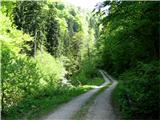 2
2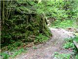 3
3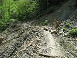 4
4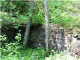 5
5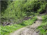 6
6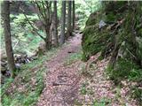 7
7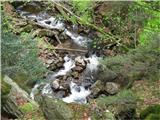 8
8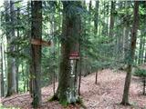 9
9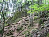 10
10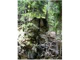 11
11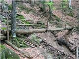 12
12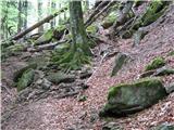 13
13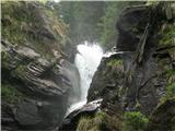 14
14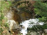 15
15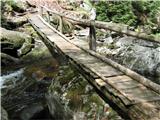 16
16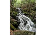 17
17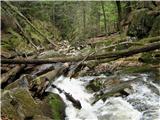 18
18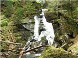 19
19
Discussion about the trail Smolnik - Veliki Šumik waterfall (through valley of Lobnica - Holcarska pot)
|
| Micika17. 08. 2010 |
Ta izlet mi pomeni saj sem blizu doma rada se sprehajam po teh poteh ko sem bila še mlada lepo je imeti tako lepi kraj ki leži na vrhu Pohorja!  
|
|
|
|
| dizzy444420. 09. 2014 |
Pozdravljeni, najprej bi rad pohvalil avtorja saj je res izjemno natančno in lepo opisal pot. Imam pa še neo vprašanje, danes sem šel na to pot ampak žal nisem moral prečkati --->slapišča potoke Verna, katerega prečimo s pomočjo jeklenice<--- saj je pravzaprav bil celotn pod vodo. Ali je potrebno počakati na naslednje leto oz brezdežje ali je stalno pod vodo?
|
|
|
|
| joža x21. 09. 2014 |
Sam hodim že nekaj let( velikokrat) po tej poti pa sem še vedno lahko prečkal Verno,mnogokrat tudi pozimi,mi je pa seveda jasno ,da ob takšnih POVODNIH,ki smo jim priča zadnje tedne,zdaj to ni mogoče. 
|
|
|
|
| navdušena15. 07. 2015 |
Kako je zdaj s potjo mimo slapov - zavarovano? Je OK, prehodna, nevarna,...?
|
|
|
|
| anjap26. 08. 2016 |
Včeraj bila na poti. Odlično prehodna. Ta prav cajt za it gor.
|
|
|
|
| seinfeld17. 07. 2017 |
Včeraj smo opravili to pot, prekrasno. Poteka ves čas ob vodi, zelo razgibana, nenavadne skale ob poti. Kljub nedelji, smo srečali malo ljudi, spremljalo nas je le bučanje Lobnice. Od parkirišča do slapu in nazaj, je točno 10km. Pot je enostavna, nezahtevna, primerna tudi za manjše otroke, le na nekaj delih je potrebno biti malo bolj previden. Morda bi pri zgornjem opisu le dodal, da kmalu po delu kjer se usmerimo naravnost navzgor(slika 7), se markirana pot s kolovoza usmeri levo in je na začetku precej zaraščena. Smo bili v dvomih, če smo pravilno zavili.
Zelo priporočam.
|
|
|
|
| Snecer15. 01. 2019 |
V nedeljo sem prehodil to pot (Smolnik-Šumik-Areh-Bellevue), je v redu označena oziroma markirana, tako da težav ni bilo. Snega je bilo malo, na nekaterih delih je potrebno biti previden zaradi poledenelosti, npr. pri prečkanju potokov.
|
|
|
|
| Stone28. 07. 2021 13:37:15 |
|
|
|
|
| Samoyedka26. 06. 2022 22:18:41 |
PD Ruše, je mogoče kaj novega glede poti? Je še vedno neprehodna?
|
|
|
|
| Tadej1. 07. 2022 06:44:47 |
Na spletni strani PZS piše, da je pot zaprta. Sem šel pa včeraj mimo po zgornji strani, pa ni bilo nobenega obvestila, o tem, da je pot zaprta.
Sem pa v praksi že večkrat opazil, da dajo včasih obvestilo o zaprti poti samo na spodnjo stran in če delaš krožno pot izveš šele v dolini, da si hodil po zaprti poti.
|
|
|
|
| m3pisnik4. 07. 2022 07:24:39 |
Prejšnji teden sem tekal iz Smolnika ob Lobnici po poti katera gre na Šumik. Ko se pot za Šumik odcepi v gozd je tabla, da je pot zaprta.
|
|
|