 | Preval - Polhograjska Grmada
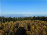
Polhograjska Grmada is an 898 m high peak located in the heart of the Polhograjski Dolomiti. The summit, which has a registration box with a stam...
2 h 45 min |
 | Gabrje - Polhograjska Grmada
Polhograjska Grmada is an 898 m high peak located in the heart of the Polhograjski Dolomiti. The summit, which has a registration box with a stam...
2 h 20 min |
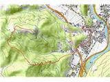
 | Rakovica - Archangel Gabriel (Planica)
Planica is an 824 m high peak located north of Škofja Loka, between Krizna Gora and Planica. From the top, where the Church of St. Gabriel the Ar...
2 h 30 min |
 | Vrhnika-Tankovska cesta - Koča na Planini nad Vrhniko (Circular path Vrhnika-Planina-Lintvern-Vrhnika)
Planina above Vrhnika is for hers inhabitants something like Šmarna gora for inhabitants of Ljubljana. It is 733 metres high and is reachable fro...
2 h 20 min |
 | Litija - Janče (via Širmanski hrib)
Janče is a 792-metre-high peak located between the Sava River and the valley of the Besnica Stream. From the top, where the mountain lodge stands...
3 h 30 min |
 | Moravče - Slivna (Pivkelj)
Slivna or Pivkelj (also Pivkelj turn) as this peak is also called is located south of Limbarska Gora. Pivkelj is also the highest point of the Mo...
2 h 30 min |
 | Divje jezero - Hleviška planina (via Prižnica)
Hleviška planina (also Hleviška planina) is a slightly overgrown but still very scenic peak. From the top, which is the house mountain of Idrija,...
2 h 30 min |
 | Prebold - Reška planina
Reška planina is a peak in Posavsko hribovje, located southwest of Prebold. The marked trail does not lead to the summit, but to a nearby viewpoi...
3 h |
 | Štore - Resevna
Resevna is a peak located south of Šentjur. On the top is a 20m high lookout tower, which gives us a beautiful view of almost the whole of Sloven...
2 h 30 min |
 | Štore - Tolsti vrh above Celjska koča (via Bojanski graben)
Tolsti, according to some records also Tovsto vrh, is located above the Celjska koča ski resort. The summit, which has a registration box and a s...
2 h 30 min |
 | Hotovlja - Sivka (via Pasja ravan)
Sivka is a grassy peak located in the westernmost part of the Polhograje Hills. In good weather, the peak offers a magnificent view from Snežnik ...
3 h |
 | Hrastnik - Klobuk (via Ravne)
Klobuk is a scenic peak located northeast of Hrastnik. The summit, which has a registration box and a stamp, offers a beautiful view of the valle...
2 h 25 min |
 | Jelovec - Žavcarjev vrh
Žavcarjev vrh is a 915m high mountain located north of the River Drava on the slopes of Kozjak. As the peak is completely overgrown, there is no ...
2 h 25 min |
 | Gorjuša - Murovica (via Dobovlje)
Murovica is a popular excursion point, accessible from the Posavina side, Domžale or from the Moravška valley. There is a bench and a registratio...
2 h 40 min |
 | Zazid - Golič (via Lipnik)
Golič is a grassy ridge stretching from Kojnik to the Slovenian-Croatian border and continuing to Žbevnica on the Croatian side. Due to the relat...
2 h 30 min |
 | Zazid - Golič (via Kojnik)
Golič is a grassy ridge stretching from Kojnik to the Slovenian-Croatian border and continuing to Žbevnica on the Croatian side. Due to the relat...
2 h 30 min |
 | Rakovica - Špičasti hrib
Špičasti hrib (Špičasti vrh on maps) is an 837 m high peak located to the west of Sveti Jošto above Kranj. There is no view from the top, which h...
2 h 20 min |
 | Zazid - Kavčič (via Lipnik)
Kavčič is a grassy peak located above the village of Rakitovec on the Slovenian Croatian border. From the top, where there are two crosses and a ...
2 h 30 min |
 | Mlinše - Pleše (via Zasavska Sveta gora)
Pleše is an 866 m high peak located between the Marela Ski Resort and Zasavska Sveta Gora. From the top, where the NOB monument is located, you h...
2 h 30 min |
 | Braslovško jezero - Grmada (Dobrovlje)
Grmada is an 898 m high forested peak located in the south-eastern part of the Dobrovlje plateau. The summit, on which the stamp is located, is n...
2 h 25 min |
| Letuš - Grmada (Dobrovlje)
Grmada is an 898 m high forested peak located in the south-eastern part of the Dobrovlje plateau. The summit, on which the stamp is located, is n...
2 h 25 min |
 | Kozje - Debeli vrh (Bohor) (via Vetrnik)
Debeli vrh is a 921-metre-high peak on Bohor between Veliki Koprivnik and Oslice. It is overgrown with dense forest, so there are no views. There...
2 h 35 min |
 | Štore - Veliki vrh above Svetina (via Marija and over Svetina)
Veliki vrh is located south-west of Svetina above Štorá. It is inhabited mainly from the south and one of the homesteads is directly below the pe...
2 h 30 min |
 | Štore - Veliki vrh above Svetina (through Bojanski graben and over Svetina)
Veliki vrh is located south-west of Svetina above Štorá. It is inhabited mainly from the south and one of the homesteads is directly below the pe...
2 h 30 min |
 | Gorica pri Slivnici - Žusem (Panoramska pot)
Žusem is a 669-metre-high hill with a colourful history and great potential for the future. It represents the northern edge of the Kozjansko regi...
3 h 20 min |
 | Puščava - Hlebov vrh (Rdeči Breg)
The Red Bank stretches between the Radoljna Gorge in the east, the Drava River in the north and the Velka Stream in the east. It is separated fro...
2 h 55 min |
| HE Ožbalt - Hlebov vrh (Rdeči Breg)
The Red Bank stretches between the Radoljna Gorge in the east, the Drava River in the north and the Velka Stream in the east. It is separated fro...
2 h 50 min |
 | Nakovana - Sveti Ilija (Pelješac)
Sv. Ilija, also known as Zmija's Bumblebee, is a 961-metre-high mountain and the highest peak on the Pelješac peninsula. From the top, you can en...
2 h 45 min |
 | Radlje ob Dravi - Sveti Pankracij (Radelca) (via Župank and Sveti Urban)
The Church of St Pancras on Radelca is located on the border ridge between Slovenia and Austria, but since 1966, following an inter-state agreeme...
4 h |
| Brezno - Sveti Pankracij (Radelca) (by Remšniški potok)
The Church of St Pancras on Radelca is located on the border ridge between Slovenia and Austria, but since 1966, following an inter-state agreeme...
2 h 50 min |
 | Muta (Spodnja Muta) - Sveti Trije Kralji (above Radlje ob Dravi)
The Church of the Three Kings is situated on an 820-metre-high hill rising above the right bank of the Radlje Stream. The church offers a beautif...
2 h 30 min |
 | Dravograd (Meža) - Anski vrh (above Pameče)
Anski vrh is a lookout point above Pameče, on which the Church of St Anne stands. From the church or the surrounding area, we have a beautiful vi...
3 h |
 | Graz Center West - Fürstenstand (Plabutsch) (via Buchkogel)
At 754 m, Fürstenstand is the highest peak of Plabutsch. It lies to the west of the city of Graz and rises about 400 m high.At the top stands the...
4 h |
 | Hotavlje - Vrhovski grič (via Slajka)
Vrhovski grič is a scenic hill located along the marked Trebija - Ermanovec trail. The grassy summit offers a beautiful view of the surrounding h...
2 h 30 min |
 | Rechnitz (Badesee) - Irrotkő / Geschriebenstein
Irrotkő is the highest peak of the Kőszegi Hegység (Kőszegi Mountains) and also the highest peak in western Hungary and the Austrian state of Bur...
2 h 30 min |
 | Ožbalt - Sršenov vrh
Sršenov vrh is a 963-metre-high peak located in the Kozjak Mountains, specifically between Ožbalt and Zgornja Kapla. The peak itself does not off...
2 h 45 min |
 | Podvelka - Klančnik (Glančnik) (via Sveti Ignacij)
Klančnik, also known as Glančnik on some maps, is an 877-metre-high peak located above the right bank of the Drava River, just a few minutes away...
2 h 30 min |
 | Deutschfeistritz - Schartnerkogel (via Gamskogel)
Schartnerkogel is a 931m high hill above the town of Deutschfeistritz (German Bistritz) in the western part of the Graz mountain range. A cross s...
3 h |
 | Vuzenica - Sedovnikov vrh
...
2 h 35 min |