 | Planina Podvežak - Planjava (via Srebrno sedlo)
Planjava is a smaller mountain group east of Kamniško sedlo. It has two peaks eastern and western. The marked path leads to the eastern peak, wh...
4 h 15 min |
 | Planina Podvežak - Planjava (via Škarje)
Planjava is a smaller mountain group east of Kamniško sedlo. It has two peaks eastern and western. The marked path leads to the eastern peak, wh...
4 h 45 min |
 | Ravne - Mittagskogel/Kepa
Kepa (also Jepa, German: Mittagskogel) is a panoramic mountain in the western Karavanke, located on the border ridge between Slovenia and Austria...
4 h 15 min |
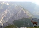
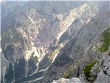
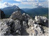
 | Planina Podvežak - Ojstrica (via Mala Ojstrica)
Ojstrica, named for its sharp shape, rises steeply above Korošica, the Logarska Dolina valley, and Robanov Kot. From the summit, which has a regi...
3 h 30 min |
| Planina Ravne - Ojstrica (via Mala Ojstrica)
Ojstrica, named for its sharp shape, rises steeply above Korošica, the Logarska Dolina valley, and Robanov Kot. From the summit, which has a regi...
4 h 15 min |
| Planina Ravne - Ojstrica (via Dolga trata and Mala Ojstrica)
Ojstrica, named for its sharp shape, rises steeply above Korošica, the Logarska Dolina valley, and Robanov Kot. From the summit, which has a regi...
4 h 45 min |
| Kraljev dol - Ojstrica (via Mala Ojstrica)
Ojstrica, named for its sharp shape, rises steeply above Korošica, the Logarska Dolina valley, and Robanov Kot. From the summit, which has a regi...
3 h 45 min |
 | Dom na Gospincu - Kalški greben (via Zvoh)
Kalški greben is a 2224 m high peak and the highest point of the ridge bearing the same name. From the summit, where there is a summit register a...
4 h 10 min |
| Planina Jezerca - Kalški greben (via Dom na Krvavcu and Zvoh)
Kalški greben is a 2224 m high peak and the highest point of the ridge bearing the same name. From the summit, where there is a summit register a...
4 h 25 min |
 | Jochalm - Reißkofel (path 235)
Reißkofel is a 2371 m high mountain in the Gailtal Alps. The summit, marked by a cross, also features a summit register. The view is particularly...
3 h 25 min |
 | Planina Pecol - Strma peč / Monte Cimone (path 640 via notch Vandul)
Strma Peč is located west of Montaž, more precisely between the Reklanica and Dunja valleys. From the summit, where a bivouac once stood, there i...
4 h |
 | Planina Pecol - Strma peč / Monte Cimone (path 641 on the slope of Viene)
Strma Peč is located west of Montaž, more precisely between the Reklanica and Dunja valleys. From the summit, where a bivouac once stood, there i...
4 h 45 min |
 | Passo Campolongo - Col di Lana
Col di Lana (Italian: also Col di Sangue, 'bloody mountain') is a 2,452-meter-high mountain located west of the Valparola and Falzarego passes. O...
4 h 20 min |
 | Fiames - Punta Fiames
Punta Fiames is a 2,240-meter-high peak located north of Cortina d'Ampezzo. The mountain is popular mainly among fans of via ferrata routes, as a...
3 h 30 min |
 | Spodnje Sleme - Obel kamen (Olševa)
Obel kamen is a 1,911-meter-high peak located in the ridge of Olševa. On the summit is a border stone marked RS XXII 1; a cross and summit logboo...
3 h 30 min |
 | Passo di Sant'Antonio - Monte Aiarnola (via normale)
Monte Aiarnola is a mountain at the far eastern end of the Sexten Dolomites group. From it there is a nice view towards the western Carnic Alps, ...
3 h 30 min |
 | Cima Sappada - Creton di Tul
Creton di Tul is a 2,288-metre mountain in the Pesarina Dolomites group of the Carnic Alps in Italy, south of Sappada and west of the neighbourin...
3 h 30 min |
 | Nassfeld - Kronalpe / Monte Corona (Auernig Höhenweg)
Koren (Italian Monte Corona, German Kronalpe) is a 1,832-meter-high peak east of the Mokrine Pass, more precisely above the Vrh Krnice saddle on ...
3 h 30 min |