 | Dom na Govejku - Tošč
Tošč, which became the highest peak of Polhograjsko hribovje decades ago when Pasja ravan was lowered by 9 m by the Yugoslav army, is located nor...
1 h 45 min |
 | Dom na Goropekah - Vrh Svetih Treh Kraljev
The Church of the Holy Three Kings is situated on a lookout above the village of Vrh Svetih Treh kraljev. From the top, which has an observation ...
1 h 40 min |
 | Govejk - Sivka
Sivka is a forested peak located west of Žiri and north of Idrija. On the summit there is a stamp of the Slovenian mountain trail and a registrat...
1 h 40 min |
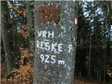 | Podmeja - Reška planina (po grebenu)
Reška planina is a peak in Posavsko hribovje, located southwest of Prebold. The marked trail does not lead to the summit, but to a nearby viewpoi...
2 h 5 min |
 | Uglov laz - Koča na Kamnem griču (via Dom na Travni Gori)
The cottage is located on Kamný hill, a scenic peak rising south-west of Sodražica. The grassy summit, surrounded by forest, offers a beautiful v...
2 h |
 | Podlanišče - Ermanovec
Ermanovec is a 1026 m high peak located between Cerkno and Gorenjska vasja, specifically above Sovodnje and Trebija. Just a few steps away from t...
1 h 35 min |
 | Suhi Dol - Sivka (by road)
Sivka is a grassy peak located in the westernmost part of the Polhograje Hills. In good weather, the peak offers a magnificent view from Snežnik ...
1 h 40 min |
 | Podblica - Sveti Mohor (Zabrekve)
The Church of St. Mohor is situated on a 952 m high hill, between Zgornja Besnica and Selce. From the church, or its immediate surroundings, we h...
1 h 40 min |
 | Govejk - Loncmanova Sivka (Mrzli Vrh)
Loncmanova Sivka is a scenic peak located above the village of Mrzli Vrh above Žirmi. From the uncultivated peak, in good weather, we can enjoy v...
1 h 40 min |
 | Šentvid pri Planini - Debeli vrh (Bohor)
Debeli vrh is a 921-metre-high peak on Bohor between Veliki Koprivnik and Oslice. It is overgrown with dense forest, so there are no views. There...
2 h |
 | Šentvid pri Planini - Brest (Bohor) (severna pot)
Brest is a peak on Bohor although it loks more like a saddle. It is an important intersection of the Bohor trails. It lies between Oslica, which ...
1 h 50 min |
 | Col - Podrta gora above Ajdovščina
Podrta gora above Ajdovščina, also called the Broke Mountain above Šturje, is a mountain rising above the Vipava valley. Some time ago, a large c...
1 h 45 min |
 | Col - Kraguljc
Kraguljc is a mountain located between Podrto gora and Sončnica. A trigonometric point is located on the lookout point, which offers a beautiful ...
1 h 35 min |
 | Ravne - Loška stena
Loška stena is located above the Upper Kolpa Valley, specifically above the villages of Grintovec pri Osilnici, Ložec and Ribjek. From the top of...
1 h 50 min |
 | Govejk - Planinska koča Mrzl'k
Planinska koča Mrzl'k is located just a few metres below the summit of Mrzlik. The hut offers a beautiful view of the neighbouring Mrzli vrh (Lon...
1 h 40 min |
 | Sveta Katarina (Zgornja Kapla) - Sveti Pankracij (Radelca) (avstrijska pot)
The Church of St Pancras on Radelca is located on the border ridge between Slovenia and Austria, but since 1966, following an inter-state agreeme...
2 h 45 min |
 | border crossing Remšnik - Tolsti vrh (na Kozjaku) (slovenska pot)
...
2 h 30 min |