Zadnjica - Koča na Doliču
Starting point: Zadnjica (642 m)
| Latitude/Longitude: | 46,3824°N 13,7604°E |
| |
Walking time: 5 h 5 min
Difficulty: easy marked way
Elevation gain: 1509 m
Elevation difference along the route: 1515 m
Map: Triglav 1:25.000
Recommended equipment (summer): helmet
Recommended equipment (winter): helmet, ice axe, crampons
Views: 59.660
 | 3 people like this post |
Access to starting point:
From Kranjska Gora, drive over the Vršič Pass towards Bovec or vice versa, but only to the 50th hairpin turn of the Vršič or Russian road (near the village of Trenta). Here, turn onto the side road, along which we park after a few hundred meters at the parking lot by the road.
Route description:
From the paid parking lot in the Zadnjica valley, continue along the marked trail, initially along the road in the direction of Pogačnikov dom na Kriških podih, Razor, Stenar, Križ, Bovški Gamsovec, Luknja, Triglav, Koča na Doliču and Kanjavec. The path first leads past a few houses or weekend cottages and after about 15 minutes of walking brings us to a marked junction where there used to be free parking, but now parking is prohibited here.
Continue along the slightly right lower road towards Zasavska koča na Prehodavcih, Koča na Doliču, Luknja and other nearby destinations (left to Pogačnikov dom na Kriških podih and other goals above Kriških podih and the lower station of the cargo cableway to Kriških podih), where a gentle road continues through scenic meadows, higher up through the forest. Just before the end of the forest road at the Planja junction or before the head of the valley in the area called Utro, a marked trail branches right towards Prehodavci.
Continue straight along the road, which soon turns into a footpath or old military mule track, along which we mostly ascend moderately on gradually steeper slopes. Still in the forest, a climbing path branches right over Komar, we continue along the mule track which then ascends in numerous serpentines, and due to the steep slopes above us parts of the path are exposed to falling rocks.
The fairly scenic path brings us at an elevation of about 1500 meters to the next junction, where the path to Koča na Doliču branches right, straight ahead the path continues towards Luknja, Pogačnikov dom na Kriških podih and Triglav over Plemenice.
Continue right towards Koča na Doliču and continue ascending along the mule track (also towards Luknja there is a mule track).
Further on we mostly ascend moderately along the mule track which leads across steep and occasionally exposed sheer slopes. Since the path is wide and well laid out it is not technically demanding, but exposed to falling rocks and due to occasional deep vistas mostly not suitable for vertigo sufferers. The path occasionally makes a few serpentines, otherwise it ascends diagonally to the right most of the time so that we gradually approach the mighty wall of Kanjavec.
Higher up a climbing path from Zadnjica over Komar joins from the right, a little further the path of Mire Marko Debelakova (path over Kanjavčeve police) branches right. The increasingly scenic path higher up makes a few more serpentines, from it a path towards Triglav branches left.
Continue straight ahead, then quickly arrive at Koča na Doliču.
Starting point - Na placu 0:15, Na placu - Utro 1:00, Utro - junction for Komar 0:15, junction for Komar - Pod Skokom 1:10, Pod Skokom - Pod steno 1:25, Pod steno - Koča na Doliču 1:00.

Along the route: Na placu (714m), Utro (984m), Odcep za Komar (1058m), Pod Skokom (1494m), Pod steno (1899m)
Photos:
 1
1 2
2 3
3 4
4 5
5 6
6 7
7 8
8 9
9 10
10 11
11 12
12 13
13 14
14 15
15 16
16 17
17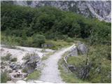 18
18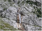 19
19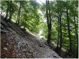 20
20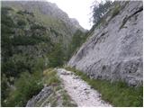 21
21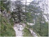 22
22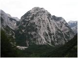 23
23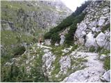 24
24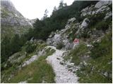 25
25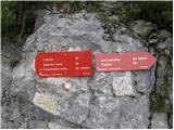 26
26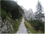 27
27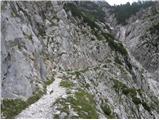 28
28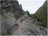 29
29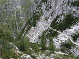 30
30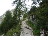 31
31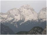 32
32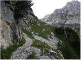 33
33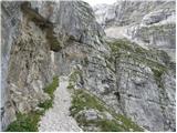 34
34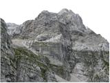 35
35 36
36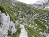 37
37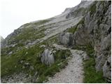 38
38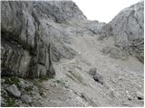 39
39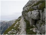 40
40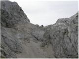 41
41 42
42 43
43
Discussion about the trip Zadnjica - Koča na Doliču
|
| jersy19. 04. 2009 |
has anyone perhaps been up there recently... I'm interested in the conditions... is it sinking in... avalanches?... I'm planning the route if I get the necessary information and right after the Vršič pass opens
|
|
|
|
| MiR22. 10. 2009 |
I just watched a contribution on channel A about the sturdy Gorenci and Gorenjci (in their best retirement years), who in four months put the hut on Dolič back in order so that it can again accommodate hikers. All congratulations for this exceptional success, as they did it in really impossible conditions. If only there were more such warm-hearted people in our little country on the sunny side of the Alps. I hope that we hikers will appreciate their work and preserve the hut for posterity. Thank you, friends of Dolič.
|
|
|
|
| Tomažke22. 10. 2009 |
I also checked out this contribution. All praise for the excellent but strenuous work.
|
|
|
|
| domoljub23. 10. 2009 |
First, praise to the retirees for the work done. But something doesn't make sense to me. Why did retirees have to take care of this, and voluntarily at that. Maybe because they still remember the shock brigade years of their youth. If they hadn't done it, would they just leave the hut in poor condition to the merciless winter that's slowly coming to the mountains. I don't know what PZS is thinking.
All praise once again to Zgornje Gorje near Bled.
|
|
|
|
| felix23. 10. 2009 |
Congratulations to these and all other volunteers who are willing to help in this way. In our club too, a lot is done with volunteer work. Most mountain huts are owned or managed by mountaineering clubs. What bothers me is that no broader campaign was launched to collect monetary contributions for the renovation of the hut at Dolič. I suggested this on the forum in the spring, but no proposals reached individual clubs. PZS could have taken care of that, instead of PZS having to renovate the hut. It's like demanding that AMZS covers the cost of repairing our car.
|
|
|
|
| krasovc23. 10. 2009 |
I didn't see the contribution about the hut. Maybe provide a link if anyone's interested?
Ah, I was at Dolič in July and it seemed there were no retirees, I only saw guys around 30-40 years old. Maybe I missed something, I don't know.. Anyway, congratulations if they really got the hut back on its feet; maybe I'd go see it on Sunday. . .
|
|
|
|
| cilag23. 05. 2011 |
Hello
I'm interested if there is any snow on the path Zadnjica - Tržaška koča na Doliču (mule track) or if there is, how much?
|
|
|
|
| rozka23. 05. 2011 |
There is still quite a lot of snow in the upper part of the path.
|
|
|
|
| cilag23. 05. 2011 |
Thanks. Are crampons necessary??
|
|
|
|
| JusAvgustin23. 05. 2011 |
no, you can keep your long toenails...
|
|
|
|
| cilag23. 05. 2011 |
Mountain lover, extreme sports enthusiast, lover of good company, professional rafting guide...
Obviously, judging by your answer, you're also an arrogant know-it-all. Not all of us are such mountains as you and not everything is obvious to us, that's why we probably ask (in your and similar wise guys' opinion only stupid things) things that are obvious to experienced mountaineers. Nevertheless, the more you ask, the more you know, and thus you also prevent many accidents. I advise you to curb your impatience towards less skilled and uninformed hikers about dangers in the mountains on this forum in the future.
|
|
|
|
| gti23. 05. 2011 |
Why get upset if someone asks inappropriate questions?
We're talking about an additional weight of approx. +1.5 to 2.5 kg! What is that compared to a slip?
In 35 days the conditions may be different...
|
|
|
|
| IgorZlodej23. 05. 2011 |
@So are crampons necessary??
For those of us on duty in the mountain rescue team at Brnik, crampons and ice axe are mandatory in July, and depending on snow conditions, possibly even in August. And some "impatient" person will say, why do you need them if you have a helicopter available! Summer snowfields are hard, even icy, so crampons are really a mandatory part of high mountain gear. They might be needed for a short crossing of a snowfield or gully, they might stay in the backpack, if you have them you can use them, if you don't you risk slipping, possibly to death, and there haven't been few such accidents. Therefore, any such question is not only inappropriate but also shows complete ignorance of high mountains.
Juš deserves an apology, yes crampons for the path from Zadnjica to Dolič are necessary and will be necessary at least until the beginning of July.
|
|
|
|
| BT8824. 05. 2011 |
Exactly, these are the movies  those who ask if crampons are needed for Dolič on May 15th either don't have crampons or need a guide. PPS well, let's leave the long ones too ... ... yeah Jus you're right. those who ask if crampons are needed for Dolič on May 15th either don't have crampons or need a guide. PPS well, let's leave the long ones too ... ... yeah Jus you're right.
|
|
|
|
| krasovc24. 05. 2011 |
Well, yeah, I don't go to the mountains much in winter either (at least not for hiking, but for skiing), but your 6-point crampons you should carry with you until August, here with us. It's only half a kg more, and takes little space..
|
|
|
|
| botjan17. 08. 2011 |
After the renovation, does the Koča na Doliču still have the same number of beds, i.e. rooms and dormitories?
|
|
|
|
| mary2. 10. 2011 |
Hello! On Tuesday I plan to go on the route Zadnjica-Koča na Doliču-Zasavska Koča na Prehodavcih (via Hribarice or via Kanjavec summit)-Zadnjica in one day. Should I keep it that way or better do the mentioned route in the opposite direction? Any advice welcome 
|
|
|
|
| miri2. 10. 2011 |
Treat yourself to two days.
|
|
|
|
| ben2. 10. 2011 |
Zadnjica-Komar-Dolič-Kanjavec-Prehodavci-Čez dol-Zadnjica In my opinion, in this direction it's a really nice tour  Can also go via the mule track from Zadnjica to Dolič, just a bit dragging. Can also go via the mule track from Zadnjica to Dolič, just a bit dragging.
Best, B
|
|
|
|
| perunika2. 10. 2011 |
On Saturday my husband and I did the described trail from Zadnjica via Koča na Doliču over Kanjavec to Prehodavci and then via Dol back to Zadnjica. We took a good nine hours with stops for snacks and photography. The day was wonderful and I highly recommend the described trail, as the weather will be nice for a few more days! Good luck
|
|
|
|
| mary2. 10. 2011 |
Thanks everyone! Definitely doing this trail on Tuesday. Already looking forward to it Yesterday I hiked Planina Blato - path "za Kopico" - Kanjavec - Koča pri 7J - Planina Blato. It was so nice I have to go up these areas again, but this time from the other side
|
|
|
|
| Pohodnica5614. 07. 2012 |
I visited it last Saturday. On this hut it no longer says Tržaška. Actually, Tržaška is covered over. Also on PZS Slovenia it's only mentioned as Koča na Doliču.
|
|
|
|
| metod31. 07. 2012 |
Hello! I would go to Koča na Doliču from Vrat via Luknja, then descend to the path from Zadnjica. I'm curious how much you descend from Luknja to the path from Zadnjica? Thanks for the answer.
|
|
|
|
| metod31. 07. 2012 |
Great, thanks !
|
|
|
|
| hribi4310. 08. 2023 14:15:48 |
Hello,
I would do this path with children (13 and 16), but I'm wondering if there is any problem or if it is really as written - easy marked path.
Meaning the path is sufficiently wide all the time, because in some pictures the description is - "Wide path leads us along the artificial ledge" or "Path crosses steep slopes"
Thanks and best regards
|
|
|
|
| Darxta10. 08. 2023 16:15:47 |
hribi43, the description of difficulty here refers to the categorization of hiking trails as known by PZS. So:
Easy hiking trail is a trail where we move with standard hiking gear, i.e. appropriate hiking boots, no need to use hands while walking, but we can facilitate movement with trekking poles.
Demanding hiking trail is a trail where we use hands at individual difficult spots. Usually it has pegs installed at places where we use them for passage mainly for stable balance.
Very demanding hiking trail, where hand use is necessary, has installed pegs and steel cables that allow safe passage in areas that would otherwise be impassable for ordinary hikers. For these trails, the use of a via ferrata set is recommended, with which we additionally secure ourselves.
If the children are not used to 9h of hiking in the mountains, then the trail will be VERY TIRING, technically speaking still EASY.
Best to look at the photos posted above and decide based on them if the trail is suitable for the trip.
Best regards and happy hiking
|
|
|
|
| mirank10. 08. 2023 20:47:05 |
Just as a curiosity - the Italian lieutenant during their rule in these parts used to drive up there on a motorbike. Of course the path is now in worse condition but enough has been said about the difficulty.
|
|
|
|
| hribi4310. 08. 2023 21:05:31 |
Thanks for the answer,
length and thus related walking time is not a problem.
We are used to hiking in the mountains, but it is true that this part, i.e. the starting point is still unknown to us, so I prefer to ask.
Best regards
|
|
|
To post a comment you must log in:
If you do not yet have a username, you must first
register.