Zadnjica - Koča na Doliču (via Komar)
Starting point: Zadnjica (642 m)
| Latitude/Longitude: | 46,3824°N 13,7604°E |
| |
Route name: via Komar
Walking time: 4 h 45 min
Difficulty: very difficult marked way
Elevation gain: 1509 m
Elevation difference along the route: 1510 m
Map: Triglav 1:25.000
Recommended equipment (summer): helmet, self belay set
Recommended equipment (winter): helmet, self belay set, ice axe, crampons
Views: 22.821
 | 2 people like this post |
Access to starting point:
From Kranjska Gora, drive over Vršič Pass towards Bovec or vice versa, but only to the 50th hairpin turn of the Vršič or Russian road (near the village of Trenta). Here turn onto the side road, along which after a few hundred meters we park at the parking lot by the roadside.
Route description:
From the paid parking lot in Zadnjica valley, continue on the marked path, initially the road towards Pogačnikov dom na Kriških podih, Razor, Stenar, Križ, Bovški Gamsovec, Luknja, Triglav, Koča na Doliču and Kanjavec. The path initially leads past some houses or cottages and after about 15 minutes of walking reaches a marked junction where there used to be free parking, but now parking is prohibited.
Continue on the slightly right lower road towards Zasavska koča na Prehodavcih, Koča na Doliču, Luknja and other nearby objectives (left Pogačnikov dom na Kriških podih and other goals above Kriških podih and lower station of the cargo cable car to Kriških podih), where the easy road leads across scenic meadows, higher through forest. Just before the end of the forest road at Planja junction or before the valley head in the area named Utro, a marked path to Prehodavci branches right.
Continue straight on the road, which soon becomes a footpath or old military mule track, along which we mostly ascend moderately on gradually steeper slopes. Still in the forest, where the mule track turns left, the climbing path via Komar branches right or straight.
The "Komar" inscription on the rock directs straight to a narrow path across the meadow towards a small stream. The path then crosses the stream and ascends the steep slope towards the chapel visible ahead. At the chapel, the path turns right and with the help of some cables ascends crossing the steep slope westwards. The path then reaches a gully along which with protections we ascend left upwards. After short ascent we leave the gully and turn right to a narrow secured ledge leading to steep northern slopes. Follow several steep sections with cable, then the path turns slightly left and traverses exposed slopes in gentle ascent. This brings us to another gully along which we ascend with protections. This time leave the gully left, then short traverse with cable to less steep slopes covered with dwarf pines and bushes.
Continuing with fine views to Pihavec and Zadnjiški Ozebnik, ascend mostly through dwarf pines. The path reaches grassy slopes, upper part increasingly scree. Approaching Kanjavec walls, path turns left with short ascent to junction joining the normal path on the military mule track.
Continue on mule track, further right branches Mira Marko Debelak path (path over Kanjavec ledges). The scenic path makes more serpentines higher, left branches path to Triglav.
Continue straight to quickly reach Koča na Doliču.
Starting point - Plač 0:15, Plač - Utro 1:00, Utro - Komar junction 0:15, Komar junction - Below wall 2:15, Below wall - Koča na Doliču 1:00.

Along the route: Na placu (714m), Utro (984m), Odcep za Komar (1058m), Pod steno (1899m)
Photos:
 1
1 2
2 3
3 4
4 5
5 6
6 7
7 8
8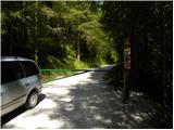 9
9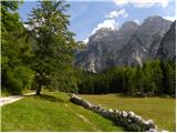 10
10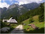 11
11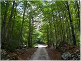 12
12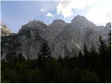 13
13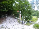 14
14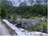 15
15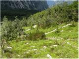 16
16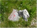 17
17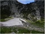 18
18 19
19 20
20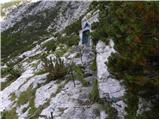 21
21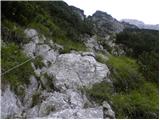 22
22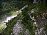 23
23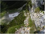 24
24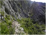 25
25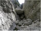 26
26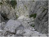 27
27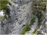 28
28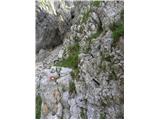 29
29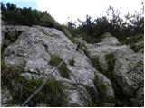 30
30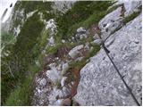 31
31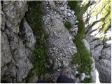 32
32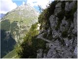 33
33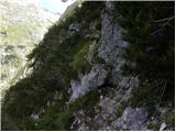 34
34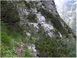 35
35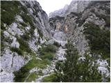 36
36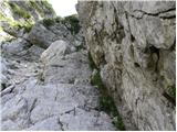 37
37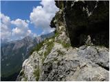 38
38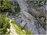 39
39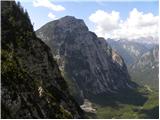 40
40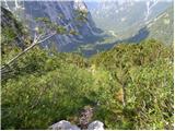 41
41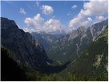 42
42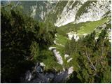 43
43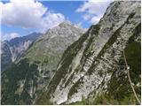 44
44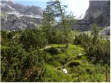 45
45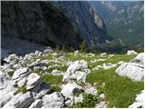 46
46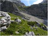 47
47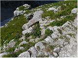 48
48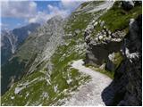 49
49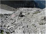 50
50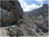 51
51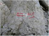 52
52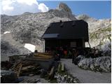 53
53
Discussion about the trip Zadnjica - Koča na Doliču (via Komar)
|
| buda112. 08. 2014 |
Hello,
at the end of August I will head to Triglav from Zadnjica - via Komar over Dolič, so I would like first-hand information on the condition of the mentioned path over Komar, and if there is still any snow under Dolič? Thanks
|
|
|
|
| IgorZlodej12. 08. 2014 |
Does this interest you now or how it will be at the end of August? For now I know!
|
|
|
|
| IgorZlodej12. 08. 2014 |
The path is in good condition, just wet every day , snow under Dolič is still there. , snow under Dolič is still there.
|
|
|
|
| buda112. 08. 2014 |
Igor thanks for that information, we'll set off when it's drier, and rather take a bottle of water in the backpack...
|
|
|
|
| ana13. 08. 2015 |
Yesterday came from Kriški podi to Zadnjica. Luckily I had arranged transport because of the circular tour, otherwise it would have ended badly. Along the entire Zadnjica up to the parking lot at the beginning, there were at least 50 cars ticketed by the police, mostly foreigners and a couple of ours. Apart from a no parking sign somewhere at the beginning, we didn't notice any special notices.
This is plain municipal banditry. On one hand, these people shout that they are forgotten by the world and the state that doesn't allocate enough funds to them, but those who come to them as tourists they calmly slaughter for a one-time profit.
Where do they even have any logic regarding tourism? As if those Hungarians, Germans, Dutch etc. came from so far just to see something that isn't anywhere else in the world??? They have to sleep, eat, drink and spend money somewhere. Probably they will never return to Trento. There they can shout again that the whole world forgets them except for two summer months. In the long term, it will ruin them for the whole year and quite rightly so if they are angry.
|
|
|
|
| planika8213. 08. 2015 |
As far as I know, after the official parking lot (located right after exiting the 50th Vršiška serpentine) there is a sign prohibiting stopping and parking. This means you cannot park further ahead. So far I have respected this prohibition and walked those extra 15 minutes. But I have always seen many cars that ignored it.
|
|
|
|
| ljubitelj gora13. 08. 2015 |
You need to park about 200m from the main road, sign prohibiting parking and stopping, but I don't know why they don't put a no-driving sign either, and I agree with Ana, ordinary theft.
|
|
|
|
| viki15. 07. 2017 |
Has anyone gone on this trail in the last few days? Is it dry?
|
|
|
|
| simon795. 07. 2017 |
I haven't been there in the last few days, nor do I know the current condition. But at the beginning of July, I would still expect some snow over Komar in some places.
|
|
|
|
| miratan19. 09. 2019 |
Hi
does anyone know what the path over Komar to Dolič is like? 
|
|
|
|
| felix3. 08. 2020 |
What is the condition of this path - I mean the fixed protection and markings?
|
|
|
|
| LISAC26. 07. 2021 08:52:49 |
Hi. Does anyone have any info on the condition of the Zadnjica-Komar-Dolič path and if there's still any snow on the path, gullies? Thanks
|
|
|
|
| Lenore26. 06. 2022 23:32:28 |
I'm wondering....did anyone of you take SVK with them?
From the pictures I really don't know where to attach it up there at all..
|
|
|
|
| darinka427. 06. 2022 07:07:37 |
You can take it with you. Then you see if you need it or not. I didn't need it there. According to own judgment.
|
|
|
|
| Lenore30. 06. 2022 08:55:43 |
The junction for Komar is nowhere to be seen, and the start of the path is very poorly marked.
|
|
|
|
| jax30. 06. 2022 09:45:59 |
You need to read the description, then be attentive at the spot where it branches off. The branch-off really isn't super visible, but if you know where to look for it, you'll find it.
|
|
|
|
| Janez Seliškar30. 06. 2022 10:54:53 |
"Lenore", SMK usually goes up on the lower part of the climbing traverse.
|
|
|
|
| mirank30. 06. 2022 13:12:59 |
Regarding the junction for Komar; the marked path on Planja towards Dolič (Luknja) follows the mulatier track in zig-zag. In between, hikers have worn shortcuts and one of them crosses the bend where the already poorly visible junction is - see picture. Otherwise, to the right upwards, the stream - gully where the ascent begins is strikingly visible.
|
|
|
|
| turbo30. 06. 2022 13:37:32 |
I took this photo on Saturday, 25.6. => see the penultimate photo in the album !!! You can see a large waterfall, to the right of it a chapel (white-blue). You can also see the little path that goes across the grass towards the waterfall, then higher it crosses the gully (stream) to the right. Orientation is the chapel, if you go in that direction, sooner or later you'll step onto the marked path, when you reach the wall, you're at the first fixed cables. Usually at the junction of the Luknja-Dolič-Komar path there is a small cairn, on Saturday I forgot to check, last autumn it was there and quite large.
https://photos.google.com/share/AF1QipOipbBQgKorZbmuro5-UYA0w_7kOQfgYre2xOdQ8-bSInLhcnJb9RgSic8teKEX1A?key=bUhsYmsxZ0ZEdVNSRzdyWU91VjhyR0E1NWlhNDJn
|
|
|
|
| LISAC30. 06. 2022 21:49:59 |
Lenore. My opinion, I went on this path the first weekend of September last year. We started at 4:20 from the parking lot in Zadnjica and in the dark with headlamps found the junction for Komar. It helps because you hear the waterfall to the right and yes, you really need to watch the bottom and the ear-like branches from it. But I had a printed path description from the mountaineering book in hand and only when we saw the chapel did I put it away in the backpack. Then enjoyment on the super path. SVK won't be much use to you here because there aren't many fixed cables, that's of course my opinion. Safe steps
|
|
|
To post a comment you must log in:
If you do not yet have a username, you must first
register.