The Kot Valley - Rjavina (ridge crossing Macesnovec-Rjavina)
Starting point: The Kot Valley (950 m)
| Lat/Lon: | 46,4157°N 13,8977°E |
| |
Name of path: ridge crossing Macesnovec-Rjavina
Time of walking: 8 h
Difficulty: very difficult pathless terrain
Altitude difference: 1582 m
Altitude difference po putu: 1750 m
Map: Triglav 1:25.000
Recommended equipment (summer): helmet
Recommended equipment (winter): helmet, ice axe, crampons, lamp
Views: 11.319
 | 4 people like this post |
Access to the starting point:
Leave the Gorenjska motorway at the Hrušica exit and follow the road towards Kranjska Gora. Just before the village of Dovje, the road branches off to the left and leads to Mojstrana (Vrata, Kot and Krma). Follow the road in the direction of the village of Radovna and the valleys of Krma and Kot. The relatively steep road then leads us past the TNP signboard, after which the road soon lays down and leads us to a crossroads where a dirt road branches off to the right into the Kot valley (straight ahead to Radovna and Krma). This sometimes slightly worse road is then followed to a parking area, where you will also see mountain signs.
Path description:
From the parking lot, first walk along the marked trail for quite some time, which leads to Stanič's hut. The path is a bit exposed in places, protected by a few rungs and two ropes in the most exposed places.
When you get to the small well on the left side of the path (there is a short part of a gutter so you can fill up with water, and next to it on a small rock there is a sign saying "keep clean"), pay attention: about 50 m further on, the unmarked path branches off the marked path up to the left, just before the marked path turns right over a torrential ravine.
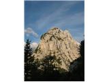
The unmarked but clearly visible path climbs quite steeply towards a large scree slope, but soon splits into two - right (upper) and left (lower). The two paths merge again higher up on the trail. The lower (left) ascends fairly steadily over scree and between dwarf pines (often marked cairns), while the upper (right) ascends quite steeply over scree at first, then leads in an easy ascent, without any major distinct climbs, to a point where the two paths merge again. From here on the path is mostly very steeply sloping, in a sparse larch forest, and the dwarf pines is exposed in many places (slip hazard), but well-traced throughout. Just below the summit, the path crosses over the ridge to the other side (so far we have been on the slope above Koto, from there on the slope above Krma). Just below the summit, the dwarf pines completely replaces the larch trees that had dominated until then. The summit itself is rocky and covered with grass.
Descend about 200 metres from the summit, then start to look out for the path that will lead to the notch between Larch and Smokers. It's a wild and pathless world, so don't be afraid to belaying with a rope! From the notch we climb about 30 vertical metres up the wall, which will lead us on a more or less easy route to the top of Dimniki. I have divided the route into three parts, the first wall is about 50 m high and delivers us to a very nice ledge covered with dwarf pines (a buttress), the second section (the most challenging) is done on the ridge cut of Dimnikov to the next flattening, which leads us to the last wall. The last wall serves the super climbing of the upper third pitch and delivers us about 100 pitches below the top of Dimnikov. There are two peaks, we descend further towards the "saw", but we avoid the saw! We retreat to the left (Krm) side of the cornice and ridge. Soon we reach a fork leading to Luknja stove (can be II-III), there is also a possibility of a detour and through the PP window to the north side from there on the ledge to the first gully, up the gully and then past the "Sculpture" back to the PP and along the "normal" to the LP (crumbly I-II). From Luknja stove descend the normal to the "route" The ridge Rjavina opens in front of us, we have difficulty retreating to the left (Krm) side, but the route is more or less strictly along the ridge cut, there are two rappels on the ridge along the rope and one more difficult chimney (IV). The rappels are equipped, also chimney. In a pleasant climbing (II-III) we slowly progress to the last corner of Rjavina (flake!, difficult, friction). Soon we reach the point where the man
Equipment: rope, a couple of pegs, a butterfly and a rock pin. There are anchors, and (a couple of) pegs. The ridge has already been skidded in winter.
Pipi Naveza wishes you a safe and above all scenic climb

Pictures:
 1
1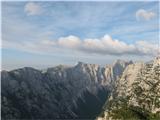 2
2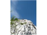 3
3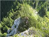 4
4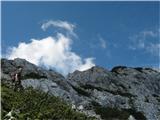 5
5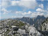 6
6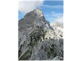 7
7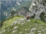 8
8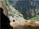 9
9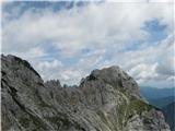 10
10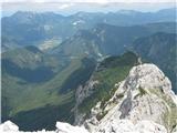 11
11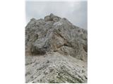 12
12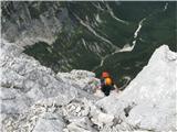 13
13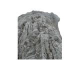 14
14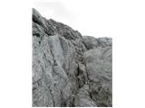 15
15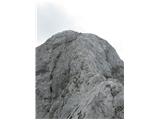 16
16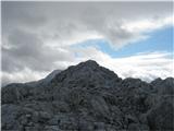 17
17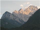 18
18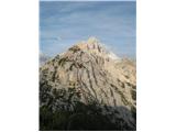 19
19
Discussion about the trail The Kot Valley - Rjavina (ridge crossing Macesnovec-Rjavina)