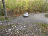
Starting point: Gašperjev hrib (1381 m)
| Lat/Lon: | 45,591°N 14,4749°E |
| |
Time of walking: 1 h 30 min
Difficulty: easy marked way
Altitude difference: 415 m
Altitude difference po putu: 450 m
Map: Snežnik 1:50.000
Recommended equipment (summer):
Recommended equipment (winter): ice axe, crampons
Views: 35.992
 | 2 people like this post |
Access to the starting point:
a) From Cerknica or Nová vas na Blokach, first drive to Bloška Polica and from there continue in the direction of Loš and Babne Polje. At Pudob turn right in the direction of Snežnik, Ilirska Bistrica, Knežak and the nearby settlement of Kozarišče. In Kozarišče, turn slightly left in the direction of Snežnik and follow the road in the direction of Snežnika at the following junctions. When Kozarišče ends, the asphalt also ends, and we continue left in the direction of Mašun and Knežak, just after the bridge over the Malá Obrh. A relatively long drive follows on a dirt road, which we follow for about 11 km, or until we reach the Leskov valley. From Leskove dolina, follow the main road for a little less than 1. 5 km, or to the point where the signs for Gašperjev hill 7 km direct you to the left on a slightly steeper road. After a further 5 km of driving, you arrive at a marked crossroads, where the inscriptions on the rock for Gašperjev hill and Snežnik direct you to the right. Follow this road to a small parking lot, at which you will see a mountain direction sign for Snežnik.
b) Drive to Pivka, and from there continue to Knežak. In Knežak, at the marked crossroads, turn left in the direction of Masun and the settlements Bač and Koritnicee. A little further on, go right in the direction of Masun and Koritnice (straight ahead Bač). After Koritnice, the road starts to climb more visibly, and then after 18 km from the main crossroads in Knežak, it leads to Masun, from where you continue driving right in the direction of Sviščaky. After about 2 km of dirt road from Mashun, you reach a crossroads, where you continue on the lower left road (the right road leads to Sviščaki), which you follow for about 4 km, or until the crossroads, which is located just after the 12 km road marker. At this junction, turn right onto the forest side road (straight ahead Kozarišče and Leskova dolina) and follow it for approximately 1. 3 km before joining the road from Leskova dolina. There is still about 4 km to go, and then you arrive at a marked crossroads, where the inscription on the rock for Gašperjev hill and Snežnik direct you to the right. Follow this road to a small parking lot, at which you will see a mountain direction sign for Snežnik. c) First take the Ilirska Bistrica, then continue to Sviščaki (the turnoff is in the middle of Ilirska Bistrica and is marked, it may be a little less visible). Initially, the asphalt road is climbed, then after about 12 km of climbing, the asphalt is replaced by macadam. There are about 7 km of macadam, and then you reach a crossroads near the Mountain Home on Sviščaki, where you continue straight towards the nearby Mountain Home on Sviščaki. From the mountain lodge, continue driving towards Mašun, where after a further 10 km of macadam, you will reach a junction where you will take a sharp right towards the Leska Valley (straight Mašun 2 km). From the junction, drive for approximately another 4 km, or to the junction located just after the road marker 12 km. At this junction, turn right onto a forest road (straight Kozarišče and Leskova dolina), continue along this road for approximately 1. 3 km, and then join the road from Leskova dolina. There is still about 4 km to go, and then you arrive at a marked crossroads, where the inscription on the rock for Gašperjev hill and Snežnik direct you to the right. Follow this road to a small parking lot, at which you will see a mountain direction sign for Snežnik.
Path description:
At the starting point, you will see signs for Snežnik, which direct you to cart track, which climbs relatively steeply through the forest. After a few minutes, the steepness subsides and cart track turns into a pleasant path which leads us further along and along an undistinguished ridge. The way forward soon leads to a viewpoint at Snežnik, which then descends slightly and leads us into the lane of the compacted forest, where it continues to climb cross-cutting. Higher up, the path leads us to a larger meadow, from which we have a fine view of the surrounding hills. Continue for some time on the grassy slope, then return to the forest, where the path begins to climb steeply. From the forest you soon pass between dwarf pines, through which you continue your ascent on an increasingly scenic slope. There is a short descent and a little-visited path from Grčovec joins us on the left.
Continue in the direction of Snežnik and continue the ascent along the marked path from dwarf pines to the unmapped summit slopes of Snežnik. Follow this increasingly scenic route all the way to the summit, which is reached after a few minutes of further walking.

Pictures:
 1
1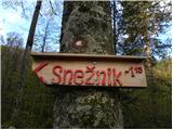 2
2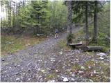 3
3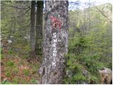 4
4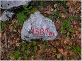 5
5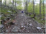 6
6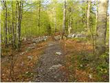 7
7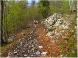 8
8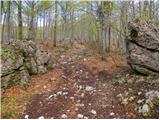 9
9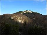 10
10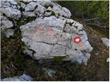 11
11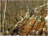 12
12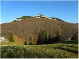 13
13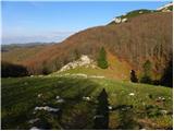 14
14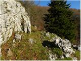 15
15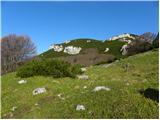 16
16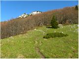 17
17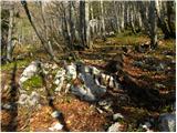 18
18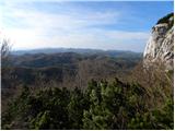 19
19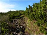 20
20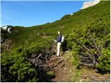 21
21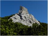 22
22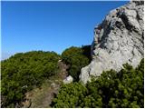 23
23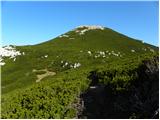 24
24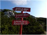 25
25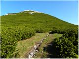 26
26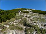 27
27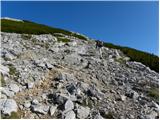 28
28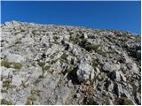 29
29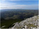 30
30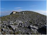 31
31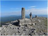 32
32 33
33
Discussion about the trail Gašperjev hrib - Snežnik
|
| vik30. 12. 2011 |
V sredo je bilo čudovito jutro z jasnino že takoj nad snežniškim gradom, doline na notranjski strani pa so ostale v megli do popoldne. Ker sem se zgodaj uspel pripeljati visoko proti Gašperjevem hribu, sem se odločil za malo daljše pohajanje po Snežniku. Najprej čez Gašperjev hrib z vzhodne strani na vrh, kjer globoki jutranji razgledi na vse strani. Brez vetra, kar je na Snežniku redko, je bilo prav celo dopoldne. Nato pa preko Malega Snežnika navzdol v smeri proti Grdi Dragi, kjer sem krenil levo navzgor v sneg v celo in prišel pri novem (obnovljenem) kažipotu na pot, ki gre s Sviščakov, po njej na vrh Snežnika še drugič. Od tam pa sem se spustil proti S in se držal levega roba ruševja na greben in nato navzdol najprej do lovske koče, od kjer še po cesti do avta in nazaj v dolino. Polno, uživaško dopoldne v soncu, ob lepih razgledih in bleščečem snegu, katerega je včeraj dobil novo porcijo tudi Snežnik.
|
|
|
|
| šoni13. 03. 2017 |
mene pa zanima, če je ta pot v primeru zelo močne burje in ledu tudi tako izpostavljena kot je tista iz Sviščakov, takoj od sedla med Snežnikoma proti koči, kjer nevarno buta burja in je v ledu zelo nevarno, možnost zdrsa daleč.
|
|
|
|
| simon7914. 03. 2017 |
Pot ni izpostavljena. V spodnjem in srednjem delu poteka pretežno po gozdu, kjer je na momente zelo strmo (lahko nevarno v primeru ledu, gozd pa burjo deloma zadrži...), vmes se dvakrat ali trikrat položi preko travnikov in višje preko rušja. Zadnji vzpon ca. 20 minut pod vrhom pa je spet strm in neporaščen - tu bi lahko bilo pozimi podobno kot na sedlu med Snežnikoma, odvisno od razmer, opreme in pohodnikovih izkušenj.
|
|
|
|
| marco14. 03. 2017 |
Ne samo da je tudi tu velika možnost zdrsa, ampak je tudi prepadno blizu sedla.
Obstaja pa druga pot, ki jo pa moraš poznati in ni označena - obvezna je tudi zimska oprema.
Srečno!
|
|
|