Klemenčevo - The Korošaški waterfall
Starting point: Klemenčevo (600 m)
| Lat/Lon: | 46,2739°N 14,5709°E |
| |
Time of walking: 45 min
Difficulty: easy unmarked way
Altitude difference: 200 m
Altitude difference po putu: 200 m
Map: Kamniške in Savinjske Alpe 1:50.000
Recommended equipment (summer): helmet
Recommended equipment (winter): helmet, ice axe, crampons
Views: 26.783
 | 5 people like this post |
Access to the starting point:
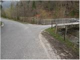
From Kamnik we drive towards Stahovica. Just after the village Godič, turn left onto the road towards Županjih njiv. At the next crossroads, turn left towards Bistričica and follow the road to the village of Klemenčevo, where you turn right over a small bridge and then park in a small parking lot. In front of the bridge there are signs for Kamniški vrh and mountain pasture Osredek.
Path description:
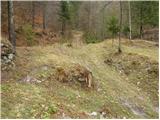
From the parking lot, continue along the main road, which climbs steeply up the left side of the stream (right bank). After a few minutes' walking, the path leads us to a bus turnaround point, behind which we see the mountain signs for Ambrož pod Krvavcem. Just a little further on, the road leads us to a small crossroads, where we continue to the right across the bridge. After the bridge, we reach the houses, at which we leave the marked path towards Krvavec. Continue to the right along the cart track, which climbs over a meadow. Cart track, which is getting worse, takes us higher up between two trestles and then leads us to a small confluence at the ruins of an old house. The way forward leads us along the right-hand side of the ruins and then over a wire fence to a stream by which we then climb. The path continues along the stream, crossing it several times. At the point where the path leaves the gorge to the right, we see the 1st waterfall, which is only a minute's walk downstream. Given the low water level, it does not deserve to be called the 1st waterfall.
The path which follows the gorge to the right, after a short climb, leads to the next waterfall, which dries up completely in dry periods. The path which climbs steeper, however, quickly leads us to a small pass, where we reach the next crossroads. To the left, first slightly downwards and then upwards, a path branches off to the next waterfall. After a five-minute walk, you reach the bottom one in the main chain of waterfalls. If you want to get to the top of the biggest one, you have to climb steeply up the left side of the waterfall (not suitable for the less experienced).

Pictures:
 1
1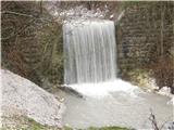 2
2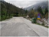 3
3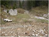 4
4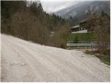 5
5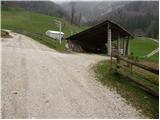 6
6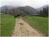 7
78
 9
9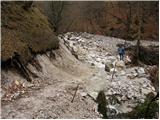 10
10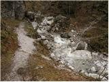 11
11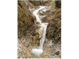 12
12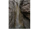 13
13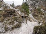 14
14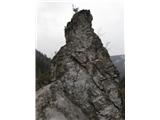 15
15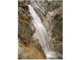 16
16
Discussion about the trail Klemenčevo - The Korošaški waterfall
|
| Kokta26. 05. 2012 |
Ja, neoznačena pot..poslušajte zvok potoka in mu sledite 
|
|
|
|
| velkavrh24. 04. 2013 |
Danes popoldne sem odšel na prijeten sprehod v sotesko Korošaških slapov. Sedaj je vode dovolj in so slapovi lepi. Že na kmalu na začetku moramo malo skreniti v levo do prvih slapov, ki so kot nekakšna korita-lepo. Šel sem do spodnjega Korošaškega slapa,ki je ta čas res veličasten.Lani v jeseni sem šel še naprej, vendar je bilo bolj malo vode.
|
|
|
|
| Ljubljana1. 08. 2015 |
Obiskali smo slapove. Samo slapovi si zaslužijo ogled. Vse ostalo v zvezi s potjo je pod kritiko: najprej opis poti - popolnoma zavajajoč in napačen. Nekje smo mogoče videli 1 do 2 markaciji.
Kdorkoli že skrbi za urejenost poti in dostop do slapov, si ne želi obiska kogarkoli, zato tudi mi ne bomo več prišli.
Izlet odsvetujem predvsem družinam z majhnimi otroci.
Lep pozdrav.
|
|
|
|
| garmont1. 08. 2015 |
V opisu poti,ki je mimogrede povsem točen, je zapisano, da je to lahka neoznačena steza, zato je temu primerno "vzdrževana". Uradnega skrbnika neoznačenih poti namreč ni, zato je vse bolj ali manj prepuščeno posameznikom, ki imajo s sabo v nahrbtniku med drugimi stvarmi še... žago.
Lp
|
|
|
|
| gams442. 08. 2015 |
saj vas ni treba kdo vas je pa prosu 
|
|
|
|
| lino2. 08. 2015 |
gams44 - zelo kratek in neposreden odgovor.
|
|
|
|
| Zamimi12. 02. 2021 |
Danes, 12.2.2021 je bil na poti sneg in tudi poledenela steza, brez derez in palic bi bila pot res težavna. Prijazni domačin nas je opozoril, da je obilni dež odnesel plaz nad slapovi in da naj bomo previdni, ker je nekaj "materiala" še ostalo in se lahko znova zruši. Prišli smo do slapov, voda je bila rjava zaradi zemlje, a nisva rinila čisto spodaj, ker se je zdelo nevarno.
Pa srečno pohajanje!
|
|
|