Makekova Kočna - Veliki vrh
Starting point: Makekova Kočna (945 m)
| Lat/Lon: | 46,3857°N 14,5043°E |
| |
Time of walking: 2 h 15 min
Difficulty: easy marked way
Altitude difference: 797 m
Altitude difference po putu: 797 m
Map: Kamniške in Savinjske Alpe 1:50.000
Recommended equipment (summer):
Recommended equipment (winter): ice axe, crampons
Views: 31.657
 | 4 people like this post |
Access to the starting point:
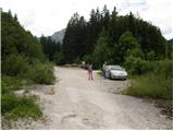
First, drive to Preddvor or to the settlement of Tupaliče (reachable from the Gorenjska highway or Kranj), then continue driving in the direction of Jezersko. When you reach Zgornje Jezersko, at the part where the road is laid, leave the main road and continue to the right in the direction of the ecological tourist farm Makek, Češka hut, Veliki vrh and the Čedca waterfall (leave the main road before the Petrol petrol station). Just after the turnoff from the main road, first descend a little and then follow the road in the direction of the Makek farm. The road then starts to climb, and we follow it to a small crossroads where the road continues to the left towards Makek Farm, and in a straight direction the road continues past the trail to the Čedca waterfall and past the trail to Velika vrh. Park in a suitable place near the crossroads so as not to interfere with the frequent forestry work.
Path description:
From the parking lot, continue along the road on the right, which climbs gently through the forest. After a good 10 minutes' walk, you will come to a sharp right turn, from which a marked path branches off to the left towards the Čedca waterfall. Continue along the road, which climbs for some time, and then leads us higher up to a place where we see a mountain sign for Velika vrh. Here we continue left up the often muddy cart track, which turns into a footpath higher up, which climbs mostly through the forest (due to the greater number of tractor trains, orientation is somewhat more difficult). The steepness then eases and the path leads us to a clearing after which the path climbs steeply. The path then turns slightly left into the forest and comes to a solitary hut in the middle of the forest.
Follow the markings carefully, as you can quickly get lost along the many paths beside the cottage. Just above the hut the path climbs steeply, then turns to the right and leads us higher up to an avalanche prone ravine (avalanche danger in winter). The path continues to climb relatively steeply up and along the ravine. Eventually the path leads us to a ridge where a beautiful view (vantage point) opens up for a short time. On the ridge the path turns left and returns to the forest.
The last part of the way to the summit awaits us. This part is a bit exposed in places, but not to dangerous in dry conditions (in wet conditions there is a high risk of slipping). A little below the summit, the path leaves the forest onto slopes covered with dwarf pines, which are then followed to the summit.

Pictures:
 1
1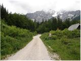 2
2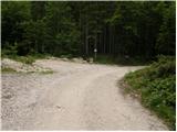 3
3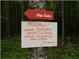 4
4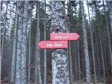 5
5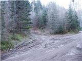 6
6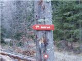 7
7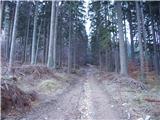 8
8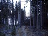 9
9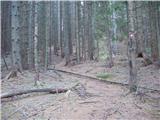 10
10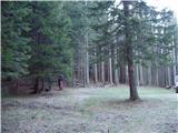 11
11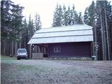 12
12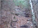 13
13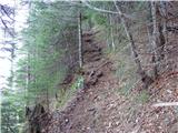 14
14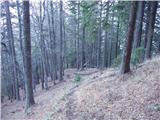 15
15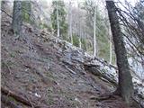 16
16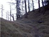 17
17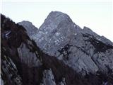 18
18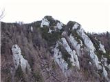 19
19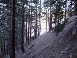 20
20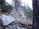 21
21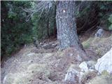 22
22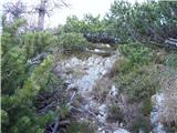 23
23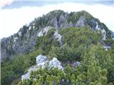 24
24 25
25 26
26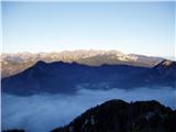 27
27
Discussion about the trail Makekova Kočna - Veliki vrh
|
| Guest24. 06. 2007 |
Brane V. Malo naporno, vendar je poplačano z čudovitim razgledom na vrhu.
|
|
|
|
| klavdy610. 01. 2009 |
izredno lep razgled, v mokrem možnost zdrsa
|
|
|
|
| klavdipo13. 06. 2009 |
Je na vrhu žig Jezerske planinske poti?
|
|
|
|
| velkavrh14. 06. 2009 |
Jaz sem bil tu pred dvema letoma .Takrat je bil žig Jezerske planinske poti.Prijeten trening za zahtevnejše ture.Priporočam!
|
|
|
|
| klavdipo14. 06. 2009 |
Bila danes! Čudovito vreme postreglo z izjemnim razgledom!  LP
|
|
|
|
| Sam.volk9. 06. 2010 |
Danes sem bil gor.Lepa planinska tura,ki te nagradi z čudovitim razgledom.Pot pa je lepo markirana.Tako da priporočam .Lp Franc
|
|
|
|
| Sam.volk9. 06. 2010 |
Danes sem bil gor.Lepa planinska tura,ki te nagradi z čudovitim razgledom.Pot pa je lepo markirana.Tako da priporočam .Lp Franc
|
|
|
|
| abes30. 03. 2011 |
V soboto imam namen iti na Veliki vrh, je bil mogoče kdo pred kratkim gor, razmere na poti ?
|
|
|
|
| tonek71. 04. 2011 |
od sedla gor v tahudih strminah še posamezne ledene flike ki se jim lahko izogneš, več koncentracije je potrebne za spust, ker je kakšen led skrit pod listjem, ampak temperature so ugodne in vsak dan je bolje  še moj nasvet:zjutraj naj se ti ne mudi, pa bo še sonce v pomoč, saj tura pa tudi ni za cel dan hoje Srečno
|
|
|
|
| abes4. 04. 2011 |
Hvala za informacije. Sem bila gor, lepa tura, kar konkretno strma, razgledi pa fantastični. lp
|
|
|
|
| robter8. 06. 2011 |
Imam vprašanje.
Tukaj piše Veliki vrh, 1742m. Pri ogledu na Geopedia.si, najdem Veliki vrh 1696 m.
Saj ne rečem, podatki se ponavadi razlikujejo +-5m, tukaj pa celih 50 m.
Ali kdo ve od kje ta razlika ??
|
|
|
|
| jaz8. 06. 2011 |
V vodniku KSA 1742m,na zemljevidih 1696m. Lp!
|
|
|
|
| Jože.9. 06. 2011 |
Vrh 1696m, je le nekakšen predvrh, na katerega pa ni speljana markirana pot, ki pelje desno spodaj pod njim, na glavni vrh 1742m.
|
|
|
|
| drobiž15. 08. 2011 |
Danes sem s svojim trem psičkam obiskala Veliki vrh. Pot se vzpenja dokaj strmo. Na poti sem srečala samo dve planinki, tako da sem se maksimalno naužila miru in lepega razgleda.
|
|
|
|
| Lunca19. 04. 2012 |
Jaz sem včeraj obiskala ta vrh. Razmere sem opisala pod trenutnimi razmerami, tukaj omenim samo to, da ture res ne gre jemati z levo roko, ampak nam pa vrh zato poplača s čudovitimi razgledi!
|
|
|
|
| Sim798. 08. 2012 |
Danes dopoldne sem se povzpel na ta vrh. Druga polovica poti je zelo strma in zahteva kar nekaj kondicije, ob povratku navzdol pa tudi precej previdnosti. Vrh pa je zelo simpatičen in ima čudovit razgled na Kočno, vrhove okoli Jezerskega, Storžič, Košuto ... Srečal nisem nobenega drugega planinca.
|
|
|
|
| izidors21. 08. 2016 |
Včeraj je bla pot razmočena, zato smo se na polovici hriba raje obrnili. Vseeno pozitivna izkušnja, povratek ni bil tako težaven, kot nas je skrbelo.
Dobra psihična priprava na naslednji napad. Meni osebno težja pot kot na Češko kočo, čeprav je po zahtevnosti opredeljena kot lahka označena pot.
|
|
|
|
| matej_131112. 08. 2024 19:10:30 |
Rad bi samo napisal, da je tale pot precej daleč od "lahke" poti. Na kar nekaj mestih bi bila zelo dobrodošla kakšna zajla ali klin, kar bi jo kvalificiralo vsaj kot "delno zahtevno".
Tako da tukaj definitivno ne priporočam hoje kakšnim prevelikim začetnikom ali tistim, ki se bojijo strmine. Prepadov sicer ni, je pa zelo strmo in precej nevarno za zdrs.
Opis izhodišča bi tudi lahko bil napisan bolje, saj človek ne ve, ali parkira pri odcepu za kmetijo, ali pri odcepu za slap Čedca (ki ga ni več in tudi ni več table zanj) ali pri odcepu za Veliki vrh. Glede na višino izhodišča, ki je napisana zgoraj, sklepam da pri odcepu za kmetijo.
Drugače pa zelo lepo označena pot in krasen razgled z vrha!
|
|
|