Planina Blato - Škednjovec (on east ridge)
Starting point: Planina Blato (1147 m)
| Lat/Lon: | 46,3112°N 13,8501°E |
| |
Name of path: on east ridge
Time of walking: 5 h
Difficulty: very difficult pathless terrain
Altitude difference: 1162 m
Altitude difference po putu: 1162 m
Map: Triglav 1: 25000
Recommended equipment (summer): helmet
Recommended equipment (winter): helmet, ice axe, crampons
Views: 6.190
 | 7 people like this post |
Access to the starting point:
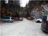
From the motorway Ljubljana - Jesenica take the exit Lesce and continue through Bled and Bohinjska Bistrica to Bohinj. At Bohinjsko jezero turn right over the bridge and pass the old church of St. John the Baptist to Stara Fužina. In the centre of the village, between the guesthouse and the cultural centre, where a replica of the Triglav Tower is erected, turn sharp left at the crossroads onto the road leading to mountain pasture Vogar and Blato. At the end of the village there is a large parking lot at the side of the road, and in summer or high season, a toll or parking fee is charged for cars there. Continue along the narrow asphalt road, which rises slightly at first and then flattens out a little over the pastures above the village. When the forest begins, we reach a crossroads where the turnoff for the Voja valley is marked on the right, and we continue to the left for Vogar and Blato. After about 6 - 7 km of moderately ascending and winding road we reach a junction where we turn right towards mountain pasture Blato (straight mountain pasture Vogar) and then follow it all the way to the parking lot and ramp in front of mountain pasture Blato. If it is full (often at weekends and in good weather in summer), there are several places to park on the roadside.
Path description:
From the parking lot continue past the ramp on the macadam road, which leads us in a few steps to the right turn, where we see the lower part of mountain pasture Blato in front of us, and to the right - just above the road we also see the beginning of the hunting trail and a signpost for mountain pasture Krstenica, where there is a shorter steel cable at the beginning for a safer step above the road. Then follow a comfortable, level path through the forest, turning slightly to the right, until it is intersected by a wide cart track with mountain pasture. Then cross cart track and follow the ascending track, which soon turns right again and runs through the woods parallel above a fairly steep track. After about 15 minutes' walking, at the end of a small clearing, the track turns more to the left and climbs over a short steep ascent in a few switchbacks, alternating between a few more level and a few steeper sections until mountain pasture Krstenica. Before leaving the wooded part of the path, a small hunting lodge can be seen on the left, and from there you soon reach the lower pasture, where the track rejoins from the right. A good 5 minutes' walk later, you arrive at the very scenic and sunny mountain pasture Krstenica, where nowadays there are about ten more or less well-kept huts, and somewhere in the middle, by the water trough, below the largest hut, there is also a wooden direction signpost. From mountain pasture, keep more to the left between the bytes or huts, then several small paths above the bytes on the west side of mountain pasture merge into a single, clearly visible path which leads us under the slopes of Krsteniškje and Jezerski Stog to the small abandoned mountain pasture Jezerce. There, after a water trough, turn right up a clearly visible path towards Jezerski preval, above which Adam and Eva are situated. Follow this track for a few tens of metres and then immediately turn left onto a less visible track leading into the small valley above. The path climbs gently at first, then leads us some way along the middle of the right slope almost horizontally under scree and steep cliffs. On the opposite side of the valley, the Ogradi steeply climb. Walk almost to the head of the valley, where the track turns right and begins to climb under the grassy slopes of Prevalski Stog towards the Mišeljski Preval. At the pass you will come across signs and the marked trail Lazovški preval - Velo polje. From the pass, where the steep path from Prevalski Stog also descends, head up the opposite slope, onto a trackless path leading between low dwarf pines and grasses, and in places between smooth rock slabs, towards Škednjovec and the Mišeljska valley. When the slope becomes a bit steeper, we also see some cairn, which points to easier passages through the rugged world of small caves, scrapes and gullies. As we can see Škednjovec and its eastern ridge ahead of us all the time, orientation in fine weather does not cause us any major problems. The first, relatively steep, headland can also be climbed straight up, but due to the steepness it is preferable to go around it on the right, and the many deep caves and chasms should be watched out for when looking for the best passages. Then you reach a comfortable grassy saddle, where you can see the mighty second peak, which is also approached on the right after a short and uneven rocky climb (on the southern sides of the ridge, the walls are more broken and precipitous). Following the traceable but rugged terrain upwards, we reach the most critical point of this climb, that is, the crossing of a smooth and steep slab about ten metres long, which in wet or frosty conditions is very dangerous for a fall or a slip. Further on, we come back to a wider but very steep rocky slope, which is quite rubbly along the wall on the left, so it is safer to head a little more to the right into a smaller or narrower, but visible from a distance, rock chute, which leads all the way to the top of the saddle of the ridge above the second pre-cliff. Climb the gully a little on the right, a little on the left, and in the upper part also in the middle, depending on where you get a better grip, but climbing does not exceed level I. Once out of this chute (about 60 m long), you step back onto a narrower grassy saddle, and from here on it's just up the ridge, which narrows more in some places and less in others, followed by a third break along the ridge and then over the last headland, which is relatively the widest yet, and you'll be surprised at how relatively comfortable the summit is as well. For the descent, we recommend the west ridge and the descent to the saddle between Škednjovec and Vrh Hribaric, which is shorter, but also very challenging due to the steepness and exposure of the ridge and by no means for the dizzy or less experienced. The quickest way back from the pass to Mišeljski or Lazovški preval is to follow the scree and the valley below Škednjevec. Approximate walking time: mountain pasture Blato - mountain pasture Krstenica: 1 hour, mountain pasture Krstenica - mountain pasture Jezerce - Mišeljski preval: 1. 5 hours, Mišeljski preval - Škednjovec (top): 1. 5 hours. Descent along the western ridge to the pass or saddle (between Škednjovec and Vrh Hribaric): 0. 5 hours.

Pictures:
 1
1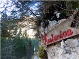 2
2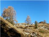 3
3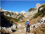 4
4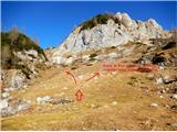 5
5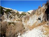 6
6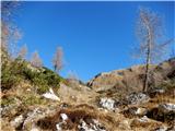 7
7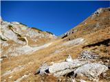 8
8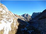 9
9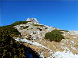 10
10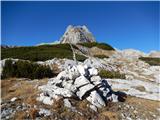 11
11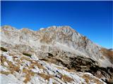 12
12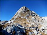 13
13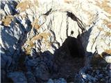 14
14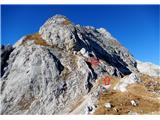 15
15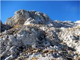 16
16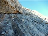 17
17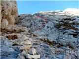 18
18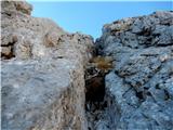 19
19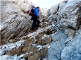 20
20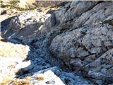 21
21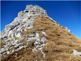 22
22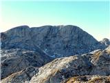 23
23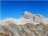 24
24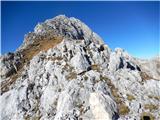 25
25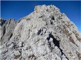 26
26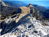 27
27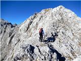 28
28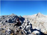 29
29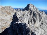 30
30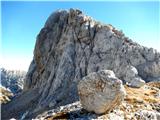 31
31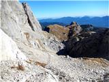 32
32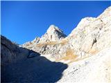 33
33
Discussion about the trail Planina Blato - Škednjovec (on east ridge)
|
| ločanka18. 11. 2015 |
Meni se je zelo dopadel svet na tem omenjenem sedlu med Škednjovcem in Vrhom Hribaric! Lep je tu pogled na severno steno Škednjovca, meni tu najlepši pogled nanj!
|
|
|
|
| Wine9. 10. 2017 |
To smer naredili včeraj, 8.10. Gre za zelo lepo prečenje... preporočam smer od vzhoda prema zahodu, tako da zoprna melišča pod vrhom prečimo za navzdol. Maceseni zlatijo! 
|
|
|
|
| pikica19. 10. 2017 |
Vse pocahnan gor po slikah. Puščica levo pa desno, še dobr, da ni kakšnega semaforja narisal.
|
|
|
|
| turbo9. 10. 2017 |
@pikica1 ... morda bo tudi v gorah kaj kmalu podobno kot v dolini  s pogledom na tablico v roki dva koraka levo, enega desno, tablico v žep in se povleče prek roba, pa spet s tablico malo sem pa malo tja  Boh pomahaj 
|
|
|
|
| kristi29. 10. 2017 |
morda je pa z vama kaj narobe?
|
|
|
|
| sAleska23. 06. 2019 |
Je na poti (pod vrhom) še kakšno snežišče? Yvala za info.
|
|
|