Rifugio Scoiattoli - Averau
Starting point: Rifugio Scoiattoli (2255 m)
| Lat/Lon: | 46,5189°N 12,0379°E |
| |
Time of walking: 1 h 15 min
Difficulty: very difficult marked way
Altitude difference: 394 m
Altitude difference po putu: 394 m
Map:
Recommended equipment (summer): helmet, self belay set
Recommended equipment (winter): helmet, self belay set, ice axe, crampons
Views: 848
 | 1 person likes this post |
Access to the starting point:
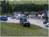
a) From Kranjska Gora via the Koren saddle to Austria, where at the first major junction continue left towards Podkloštro / Arnoldstein and Trbiz / Tarvisio. At the end of Podklošter, the signs for Šmohor / Hermagor direct you to the right on the regional road, which takes you past this town to the end of the Ziljska valley, or more precisely to Kötschach-Mauthen, where you turn right towards Oberdrauburg. The road continues over the Gailbergsattel Alpine pass (982 m), after which you descend into the above-mentioned town. After crossing a bridge over the River Drava, turn left towards Lienz. At the main roundabout in Lienz, turn left towards Sillian and Itali. Next, cross the national border between Austria and Itali and follow the main road to Dobbiaco/Toblach, where you turn left towards Cortina d'Ampezzo. Once in Cortina d'Ampezzo, follow the signs for the Passo Falzarego Alpine pass. The road starts to climb steeply above Cortina d'Ampezzo, and we follow it for some time, more precisely to the point where, just before a sharp right turn to the left, the road branches off and we quickly reach the large parking lot at the Rifugio Bai de Dones hut. Next, we buy a ticket and take a four-seater to the Rifugio Scoiattoli. From Kranjska Gora to the starting point is 208 km.
b) From Kranjska Gora via Border crossing Rateče to Trbiz / Tarvisio and then on the motorway to Udine. Leave the motorway at Tolmezzo, from where we continue driving towards Ampezzo and on to the Alpine pass Passo della Mauria (1298 m). The road then starts to descend and leads into the Cadore valley, where we continue to the right towards Auronzo di Cadore. At the next crossroads follow the signs for Cortina d'Ampezzo. When you arrive in Cortina d'Ampezzo, follow the signs for the Passo Falzarego Alpine pass. The road starts to climb steeply above Cortina d'Ampezzo, and we follow it for some time, more precisely to the point where, just before a sharp right turn to the left, the road branches off and we quickly reach the large parking lot at the Rifugio Bai de Dones hut. Next, we buy a ticket and take a four-seater to the Rifugio Scoiattoli. It is 198 km from Kranjska Gora to the starting point. c) From Nova Gorica, drive into Itali and continue on the motorway to Portogruaro, where at the motorway junction you turn towards Belluno. Follow the motorway to its end (do not turn towards Belluno) and then continue driving towards Cortina d'Ampezzo. When you arrive in Cortina d'Ampezzo, follow the signs for the Passo Falzarego Alpine Pass. The road starts to climb steeply above Cortina d'Ampezzo, and we follow it for some time, more precisely to the point where, just before a sharp right turn to the left, the road branches off and we quickly reach the large parking lot at the Rifugio Bai de Dones hut. Next, we buy a ticket and take a four-seater to the Rifugio Scoiattoli. From the border crossing to the starting point is approximately 230 km.
Path description:
From the Rifugio Scoiattoli hut, which offers a fine view of the Cinque Torri, turn right after the Rifugio Nuvolau and Rifugio Averau signs. The way forward is along a stone road, or a much more pleasant to walk parallel mountain path, which climbs up on the left side of the road. After a moderate climb of just over 20 minutes, over a scenic and initially grassy slope, the path splits into two parts (the crossroads is unmarked).
The left-hand path, which continues on a moderately steep slope, leads to Nuvolau, while we continue on the right-hand path, which joins the above-mentioned road. Continue along the road, which leads to a small valley between the peaks Nuvolau and Averau, and we continue along it until we reach the saddle between the two peaks, where the Averau mountain hut is situated.
From the hut, turn right and follow the mountain road. After a few metres, the sign "Ferrata Averau" will direct you upwards to the left. The path then first crosses the scree on the eastern side of the mountain and soon turns to the left where you enter the climbing part of the route. At the start of the climbing route, climb steeply along a ropeway over a steep wall and then reach a crossroads. The left-hand, slightly easier route climbs vertically on scree through a vent. The right-hand path also climbs almost vertically, but there are no steel cables. It should be noted that the left-hand path is often wet and the snow also stays a little longer. After a short steep section, the two paths rejoin and there is a steel cable crossing to the right. The climbing part of the route is quickly over and you soon reach the less steep summit slopes of the mountain. In the last part of the route, the trail is no longer difficult and soon you reach a very scenic summit.
Rifugio Scoiattoli - Rifugio Averau 30 minutes, Rifugio Averau - Averau 45 minutes.

Pictures:
 1
1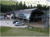 2
2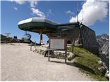 3
3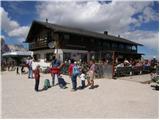 4
4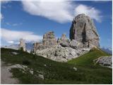 5
5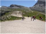 6
6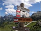 7
7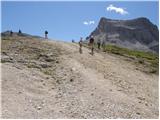 8
8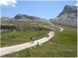 9
9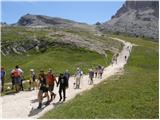 10
10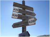 11
11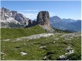 12
12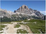 13
13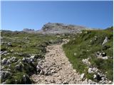 14
14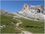 15
15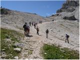 16
16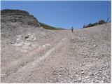 17
17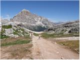 18
18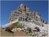 19
19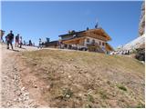 20
20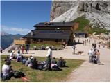 21
21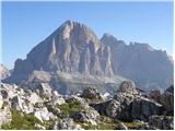 22
22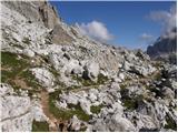 23
23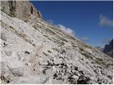 24
24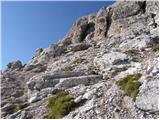 25
25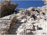 26
26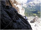 27
27 28
28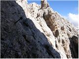 29
29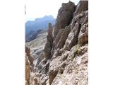 30
30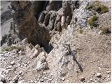 31
31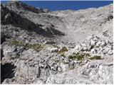 32
32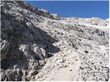 33
33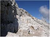 34
34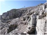 35
35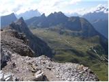 36
36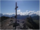 37
37
Discussion about the trail Rifugio Scoiattoli - Averau