Studenice - Source of Topli (Studeniški) potok (Studenice - source of Topli potok - Pritensko)
Starting point: Studenice (260 m)
Name of path: Studenice - source of Topli potok - Pritensko
Time of walking: 30 min
Difficulty: easy marked way
Altitude difference: 35 m
Altitude difference po putu: 110 m
Map: Posavsko hribovje Boč - Bohor 1:50.000
Recommended equipment (summer):
Recommended equipment (winter):
Views: 1.582
 | 2 people like this post |
Access to the starting point:
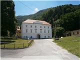
a) From Ljubljana, leave the motorway at Slovenske Konjice and drive through Žič, Loč and Zbelov and into the centre of Poljčany. In the centre, turn right towards Studenice and after about three kilometres you will reach Studenice, where you will continue right over the bridge over the Dravinja river into the central part of the settlement. Park safely in front of the monastery complex.
b) From the route of Maribor, leave the motorway at Slovenski Bistrica, where signs direct you to Poljčane. In the centre, turn left towards Studenice and after about three kilometres you will reach Studenice, where you will continue right over the bridge over the Dravinja river into the central part of the settlement. Park safely in front of the monastery complex.
c) From the route of Ptuj, Kidričevo, via Ptujska Gora, Majšperk and Makole, you will reach Studenice, where you will turn left over the bridge over the Dravinja River into the central part of the settlement. Park safely in front of the monastery complex.
Path description:
After a short tour of the central part of Studenice, continue to the left of the monastery complex by the parish church. In the passageway between the parish and the Studenice Vintners' Association, continue up the cart track along the stone walls. The path to Studenica Castle also branches off to the left, higher up and soon again to the left along the path is a small stream with water flowing in a wooden trough. Further along the path, on the right, you enter through an iron gate, the old nuns' cemetery of the Dominican and Magdalene nuns who have marked the history of Studenice over the turbulent centuries. Further along the path, to the left, a stone and wood fountain and the remains of the reinforced concrete skeleton of a quarry. Somewhere the only "stranger", which somehow blended into the environment. A few more steps and the spring/springs of the stream are more or less rich in water. The world higher up is typically somewhere similar to a karst, limestone area and their water content depends on precipitation, melting snow. A few benches in an oasis of peace and quiet and a small wooden footbridge to cross the stream at higher water levels.
After a short visit, we continue upwards, now on the old Roman road, which has preserved the original form of the basic route higher up to Boč over the centuries. At the exit to the forest road turn right, on the left the road leads higher into the world of Boč, Donačka gora. . .
Continue along the well-fortified forest road, surrounded by deciduous woods, towards your destination. Soon we reach Pritensko Plateau, to the right of the path are vineyards and also a nice view down to Studenice, Makole. . . , to the left of the path is a small hunters' warehouse of LD Poljčane.
The Pritensko point is 365 metres high. The trail is 1700 metres long and has +110 positive vertical metres and -10 negative vertical metres.

Pictures:
 1
1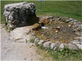 2
2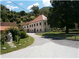 3
3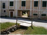 4
4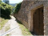 5
5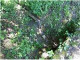 6
6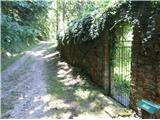 7
7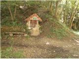 8
8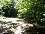 9
9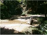 10
10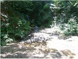 11
11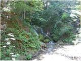 12
12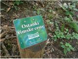 13
13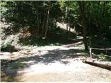 14
14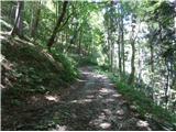 15
15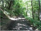 16
16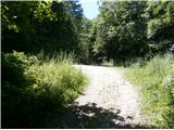 17
17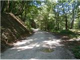 18
18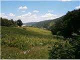 19
19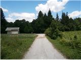 20
20
Discussion about the trail Studenice - Source of Topli (Studeniški) potok (Studenice - source of Topli potok - Pritensko)
|
| bruny9. 12. 2020 |
V večerni in rahlem sneženju tja in nazaj. Do pet/šest centimetrov snega, temperatura okoli ledišča in  to je bilo to...
|
|
|
|
| bruny12. 10. 2021 13:37:29 |
Kmalu po poldnevu danes, tja in nazaj v Studenice. Izvir je ,,rahlo,, vodnat...
|
|
|
|
| bruny30. 01. 2022 18:13:48 |
V kratki aktivnosti tja in nazaj v popoldansko/večerni...
|
|
|
|
| bruny18. 10. 2022 14:00:21 |
Tja in nazaj kmalu po poldnevu...
|
|
|