Suhadolnik - Grintovec (via Kokrsko and Mlinarsko sedlo)
Starting point: Suhadolnik (901 m)
| Lat/Lon: | 46,3352°N 14,5102°E |
| |
Name of path: via Kokrsko and Mlinarsko sedlo
Time of walking: 5 h 45 min
Difficulty: very difficult marked way
Altitude difference: 1657 m
Altitude difference po putu: 1800 m
Map: Kamniške in Savinjske Alpe 1:50.000
Recommended equipment (summer): helmet
Recommended equipment (winter): helmet, ice axe, crampons
Views: 40.229
 | 3 people like this post |
Access to the starting point:
From the motorway Ljubljana - Jesenice take the exit Kranj - East and follow the road towards Jezersko, but only as far as the village of Kokra. In this village, just a few metres before the road crosses the bridge over the Kokra River, you will see a road leading towards Suhadolnik. The road turnoff is located when we are on the right side of the river (left bank) and the road marker is approximately 7 km. Follow this road to the parking area, which is about 300 m in front of the Suhadolnik farm.
Path description:
At the beginning of the parking lot, you will see mountain direction signs directing you to the road, which will take you to a small crossroads near the Suhadole farm in less than 5 minutes' walk. Here we continue on the right-hand road, and we follow it for about 5 minutes, or until we reach the place where the signs lead us to the ascending cart track. We continue for a short distance on cart track, and then the signs direct us to the right onto a footpath which climbs moderately through the forest. Higher up, we return to cart track, which leads us a few metres further to a forest road, which we then follow to its end (it takes about half an hour to get here).
At the end of the road, the marked path splits into two parts. Continue along the left-hand path (to the right, the slightly easier "Old Path"), which continues to climb along the folded cart track. A little further on, the markings direct us slightly to the right onto torrential layers of sand, and the path continues through the forest on the other side, where it starts to climb steeply. Higher up, we reach a small cave, and the path beyond it becomes technically difficult. With the help of a rope ladder, we climb a step higher, and the path then continues along a steep slope, where occasionally a wedge helps us. Higher up, the path turns to the right, climbs steep and, especially in the wet, slippery slopes and then leads to an excellently protected crossing. With the help of wooden steps or ladders and the aid of a rope ladder, we climb up the steep slope, which would be very dangerous without the aforementioned fixed safety gear. Higher up, we are helped by a few more pegs, and the route then lays down and crosses a short exposed slope, where we are helped by an emergency fence. Just a little further on, we come to the next ladder, which does not have a belay, but the crossing is not particularly difficult. There is a short descent into a small gully, which is crossed after this. On the other side of the gully we climb steeply (a few staples help us), and then the path slowly lays down and in a few 10 steps of further walking leads us to a place where it joins the slightly easier "Old Path".
There is a short cross-climb and the path leads us to a larger plain where the "old hut" once stod. Cross the tall grasses to the other side of the plain and arrive at a marked crossroads. Continue straight ahead (left Kočna over Grdi graben) along a moderately steep path, which continues to climb through lane of bushes. Higher up, the path completely lays down for a while, then leads us between dwarf pines, where it starts to climb more steeply. Follow this slightly steeper path, which offers increasingly beautiful views, all the way to the Cojzova koča on Kokrsko sedlo.
From the saddle, continue left in the direction of Grintovec, Kočna and Skute. The path climbs steeply immediately above the saddle and leads us slightly higher to a crossroads where the path to the bivouac under Grintovec and Skuta branches off to the right (straight Grintovec over Streha and Kočna). We take this initially slightly less visible path, which leads us in a moderate ascent to a picturesque passage over the Little Gate. Beyond the narrow passage Mala vratca, the path begins to descend a steep and occasionally slightly exposed slope. At the end of the descent, which takes us about 100 vertical metres, we are helped by a few wedges. There is a gully crossing and then a climb through the high mountains to the bivouac below Grintovec.
From the bivouac, we continue along the marked trail, which quickly leads us to a crossroads. Continue straight in the direction of Skute and Grintovec (right Kamniško sedlo, Rinke and Turska gora) along a relatively gently sloping path, which soon leads to the next crossroads. Again, continue along the left path (right Skuta), which leads us further across a karst world full of scrapes and potholes. Next, carefully follow the markings which, after a short climb, lead us to Mlinarsko sedlo, where we join the path from Jezersko. Continue left in the direction of Grintovec (right Dolgi hrbet and Skuta) along the path, which becomes technically demanding. The path continues along and along the exposed ridge in places, and then passes to the axial side of the ridge, where it becomes a little more difficult, but the numerous fixed safety gear are helpful. The path, which is exposed to falling rocks in the upper part, leads us to the summit after about 1 hour's walk from Mlinarsko sedlo.
I recommend descending via the Grintovec roof.
Suhadole - Kokrsko sedlo 2:30, Kokrsko sedlo - bivouac under Grintovec 1:15, bivouac under Grintovec - Grintovec 2:00.

Pictures:
 1
1 2
2 3
3 4
4 5
5 6
6 7
7 8
8 9
9 10
10 11
11 12
12 13
13 14
14 15
15 16
16 17
17 18
18 19
19 20
20 21
21 22
22 23
23 24
24 25
25 26
26 27
27 28
28 29
29 30
30 31
31 32
32 33
33 34
34 35
35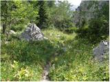 36
36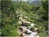 37
37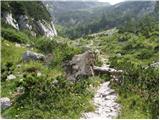 38
38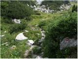 39
39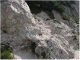 40
40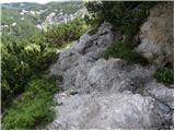 41
41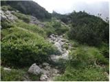 42
42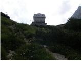 43
43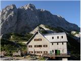 44
44 45
45 46
46 47
47 48
48 49
49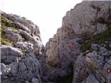 50
50 51
51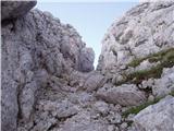 52
52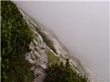 53
53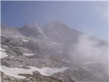 54
54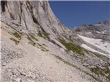 55
55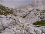 56
56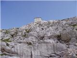 57
57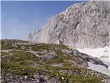 58
58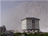 59
59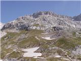 60
60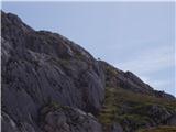 61
61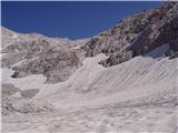 62
62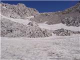 63
63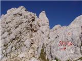 64
64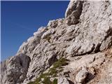 65
65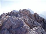 66
66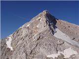 67
67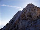 68
68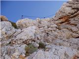 69
69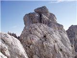 70
70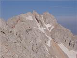 71
71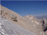 72
72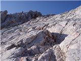 73
73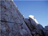 74
74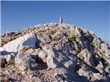 75
75 76
76
Discussion about the trail Suhadolnik - Grintovec (via Kokrsko and Mlinarsko sedlo)
|
| mirccar2. 09. 2009 |
V nedeljo bi se odpravil na Grintovec iz Suhadolnika čez Kokrsko in Mlinarsko sedlo, pa me zanima kaka je situacija na tej turi ali je kje kako snežišče in ali potrebujem samovarovalni komplet! Lp, Miran 
|
|
|
|
| nata243. 09. 2009 |
Z Mlinarskega sedla proti vrhu manjka en klin, ampak ni panike. Sama sem šla pred parimi tedni s Češke koče in kolikor se spominjam, na drugi strani ni bilo snežišč, vsaj ne omembe vrednih. Se vidimo v nedeljo na Grintovcu, grem tudi jaz s "fotrom" od Suhadolnika čez Kokrsko sedlo in potem čez Streho. Lp, Nataša
|
|
|
|
| planika822. 08. 2015 |
Mi mogoče kdo zna povedati, za koliko se podaljša pot, če s Skute nadaljujem preko Mlinarskega sedla na Grintovec (in se s Skute ne spustim direktno preko Velikih podov mimo bivaka na Kokrsko sedlo) in potem na Kokrsko sedlo? Koliko približno je od razcepa proti Velikim podom pa do Grintovca?
|
|
|
|
| SunBurned3. 08. 2015 |
Jaz tudi načrtujem podoben itinerar in po mojih izračunih pride:
Skuta-Dolgi hrbet (vrh) 1:00
Dolgi Hrbet-Mlinarsko sedlo 0:30
Mlinarsko sedlo-Grintovec 1:00
Grintovec-Kokrsko sedlo <2:00
+postanki seveda.
|
|
|