Suhadolnik - Kokrska Kočna (on southwest ridge)
Starting point: Suhadolnik (901 m)
| Lat/Lon: | 46,3352°N 14,5102°E |
| |
Name of path: on southwest ridge
Time of walking: 6 h 30 min
Difficulty: very difficult pathless terrain
Altitude difference: 1619 m
Altitude difference po putu: 1619 m
Map: Kamniške in Savinjske Alpe 1:50.000, Grintovci - 1 : 25 000
Recommended equipment (summer): helmet
Recommended equipment (winter): helmet, ice axe, crampons
Views: 5.260
 | 4 people like this post |
Access to the starting point:
From the motorway Ljubljana - Jesenice take the exit Kranj - East and follow the road towards Jezersko, but only as far as the village of Kokra. In this village, just a few metres before the road crosses the bridge over the Kokra River, you will see a road leading towards Suhadolnik. The road turnoff is located when we are on the right side of the river (left bank) and the road marker is approximately 7 km. Follow this road to the parking area, which is about 300 m in front of the Suhadolnik farm.
Path description:
From the parking lot at Suhadole, calibrate your stride towards Kokrsko sedlo, but only as far as cirque Suhi dol. Here we take the second left fork and follow the steep cart track to where a modest track branches off at a sharp right turn into a forest slope (about half an hour from the time we left the markers in Suhi dol). The track quickly disappears, and we just keep traversing the slope until we can see the picturesque rock face in front of us. After a somewhat uncomfortable descent, we cross under the wall and follow the steeps on its left edge into the clotted forest. Cross a short distance to the left to reach a grassy clearing - here look to the right and grasp the slope, following the steep gully or passages to the right of it.
After the gully, cross left and slightly uphill to a grassy flat. In a satisfyingly wild environment, the steeps of the southern expanses of the Kočna are revealed; progress towards the rocky head Mala vratca and you will soon enough come across a modest wooden ladder. Above it, we progress over isolated grassy-rocky jumps and steep grasses to an obvious notch between Mala vratca on the left and the south-west ridge of Koča, which slopes away to the right of it.
At the notch, the major orientation problems are over. Advancing right, via a short jump, one ascends to a steel cable and from it via a steep step (weak II. ) to a ridge where the further route is revealed. There are about 500 metres of climbing ahead on the more difficult SW ridge of Koča, which does not exceed climbing level I.
Climb up the grass to a sharp side ridge and cross it to the right (mogic). Avoid the rocky ridge tower by following the ledge to the right: it will lead us to the contact with the gully, which will henceforth be our constant companion to the Na Križu summit. When the ridge becomes more passable, climb it again.
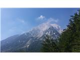
The route becomes more and more beautiful, the climbing is not too difficult; if the ridge becomes too steep, look for an easier passage along the gully on the right. Shortly after the point where the wall on the left side of the ridge is interrupted by a steep gully, it becomes steeper, indicating in places the characteristic features of the broken wall. The terrain is rather soft, but the holds are mostly satisfactory and the climbing is quite pleasant. On the left you will see a small natural window, on the right you can look for easier bypasses. Shortly afterwards, near the Na Križu summit, the route branches off; after joining the north-west ridge of Koča, after a few metres to the left, the viewpoint is reached. From the Na Križu summit, continue along the ridge eastwards towards Kokrska Kočna. Grebenc is quite sharp, but as long as nature remains lenient, we will also be guided by some cairns.
When the ridge becomes too difficult, follow in the footsteps of its predecessors and turn right (south) and traverse under it (don't turn too low). A slightly exposed ledge and individual places of 1st level climbing await. The terrain is quite crumbly, so extra caution is not superfluous.
On returning to the ridge, a view of Grintovec is revealed, and a careful look reveals the ropes from the Kokrska Kočna route on the left. Descend diagonally to the junction with the marked trail, cross the scree and climb up Kokrska Kočna on a path that is protected in places.

Pictures:
 1
1 2
2 3
3 4
4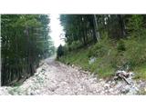 5
5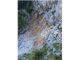 6
6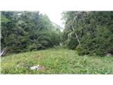 7
7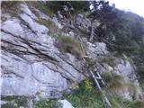 8
8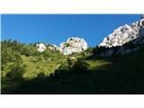 9
9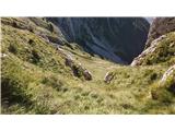 10
10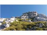 11
11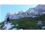 12
12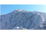 13
13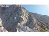 14
14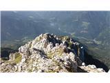 15
15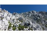 16
16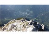 17
17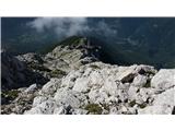 18
18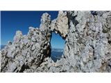 19
19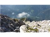 20
20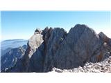 21
21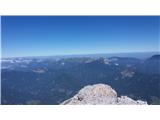 22
22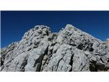 23
23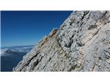 24
24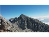 25
25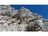 26
26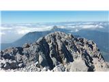 27
27
Discussion about the trail Suhadolnik - Kokrska Kočna (on southwest ridge)
|
| matic421. 07. 2019 |
Zame najlepši pristop na Kočno. Z nekim normalnim tempom se pride gor v petih urah.Pohodne palice so zelo priporočljive. Še nekaj o začetnem pristopu: v ravnici Suhi dol je prvi kolovoz levo položen in zaraščen, kakšnih 50m naprej je levo drugi strm kolovoz - ta je pravi. Držimo se naravnost mimo odcepov levo in desno do ovinka.Za tiste ,ki boste sestopali mimo bivaka po Habjanovem opisu pa tako: od bivaka gremo po grebenčku le kakšnih 20m, zavijemo desno proti melišču in se spustimo po njem do konca,na levi med redkimi smrekami sestopimo po strmih travah kakšnih 50m, prečimo po travah proti desni pod krajši skok (ostanki stezice), sledi dolgo prečenje proti desni čez trave v smeri grape (od daleč vidna stezica, ki jo preči), prečimo grapo, nadaljujemo prečno desno v rahlem spustu čez trave, pridemo do grobega ozkega melišča, ob njem se po desni strani spuščamo po travah kakšnih 100 višinskih metrov dokler se grapa ne prelomi čez strm skok, skok obidemo po desni v gozdu ,kakšnih 10m pred skokom in 10m desno od grape je jeklenica, čez najstrmejši del si pomagamo z njo, ko je večje strmine konec, polagoma zavijemo levo proti grapi, ki je sedaj travnata in plitva, po travah se spuščamo vse do gozda in potem še po gozdu kakšnih 50-100m dokler ne pridemo do kolovoza.
|
|
|