Starting point: Zadnjica (642 m)
| Lat/Lon: | 46,3824°N 13,7604°E |
| |
Time of walking: 5 h 15 min
Difficulty: difficult marked way
Altitude difference: 1777 m
Altitude difference po putu: 1780 m
Map: TNP 1:50.000
Recommended equipment (summer): helmet, self belay set
Recommended equipment (winter): helmet, self belay set, ice axe, crampons
Views: 21.759
 | 1 person likes this post |
Access to the starting point:
From Kranjska Gora, drive over the Vršič pass towards Bovec or vice versa, but only as far as the 50th serpentine of the Vršiška or Ruska road (near the village of Trenta). Here you turn onto a side road, and then park for a few 100 metres in a roadside parking lot.
Path description:
The described path is closed again since 30. 7. 2016, because the rock boulder is active again.
From the parking lot, continue along the road, which takes you past a few houses (mainly on weekends) in about 15 minutes to a place where the road splits into two parts (there used to be a parking lot at the crossroads, but now parking is prohibited).
From the old parking lot, take the road to the left in the direction of Pogačnikov dom na Kriških podih (the road to the right leads to Prehodavci and Dolič). After 15 minutes of further walking, the road leads to the bottom station of the cargo cableway, where it ends.
The ascent continues along a marked footpath (mulatjeri) which climbs moderately through the forest. The path climbs above the valley of the White Stream and quickly leads to very steep slopes (risk of falling rocks), over which a very wide footpath leads. The path then crosses the Veliki Presek ravine, after which you reach a short exposed ledge, which you cross with the help of a rope. The path then returns to the forest, where it climbs moderately in a number of switchbacks. A little further on, the path leads us under a small overhang, where we can see a number of sticks that hikers put up to keep the rock from rolling down into the valley (the sticks are put up more as a joke than for real). The path then crosses a couple of small ravines, and then leads us past a chapel to a larger ravine. With a little care (easy) we cross the aforementioned ravine, after which we climb up to a pleasant resting place (two benches along the way) within a few minutes of further walking. Next, cross another larger ravine (in early summer, the possibility of snowfields), and then the path returns to the forest. Higher up, the forest becomes thinner and the path steeper and more scenic.
The path, which continues to climb along an old mulatier, then passes two more benches and leads to lane of dwarf pines, after which it turns into a rockier world. We continue to climb over small scree fields, along an increasingly scenic path, which leads us higher up to a pleasant little spring.
Only a few 10 steps above the spring, we will come to an unmarked crossroads, where an unmarked path branches off to the right towards Spodnje Kriško jezero (2 minutes), and we continue slightly to the left along a further wide mountain path. The path ahead leads us past small ruins, and we follow it all the way to a marked crossroads, where we continue to the right in the direction of Pihavec, Bovški Gamsovec, Stenar and the Vrata valley (left Pogačnikov dom 3 minutes). Continue the ascent along the increasingly scenic path, which soon branches off to the right to Pihavec (straight ahead Stenar, Križ and Vrata). After a short climb, an unmarked path from Dovški Vrat joins us from the left. Here the path turns to the right and first crosses scree, then turns slightly to the left and starts climbing towards the Čez Kamen notch. The path then follows the scree to a rock jump, which is also the only difficult place on the path. Here the path climbs vertically on scree. The use of a helmet is also obligatory as there are a lot of rocks above the scrambles on the path. Once you have climbed the rock jump with the aid of the crampons, there is a relatively short climb along a rope. Be very careful here not to break through the rocks. There is a short climb up to the Čez Kamen notch (2331m). At the notch, the trail turns right and then follows the south side of Pihavec westwards. At the end, the trail turns slightly right again and there is a short, easy climb to the summit. Zadnjica - Pogačnikov dom 4:00, Pogačnikov dom - Pihavec 1:15.

Pictures:
 1
1 2
2 3
3 4
4 5
5 6
6 7
7 8
8 9
9 10
10 11
11 12
12 13
13 14
14 15
15 16
16 17
17 18
18 19
19 20
20 21
21 22
22 23
23 24
24 25
25 26
26 27
27 28
28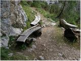 29
29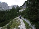 30
30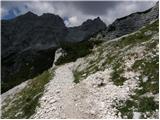 31
31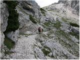 32
32 33
33 34
34 35
35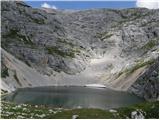 36
36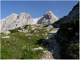 37
37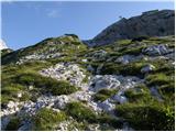 38
38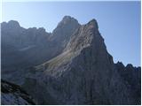 39
39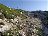 40
40 41
41 42
42 43
43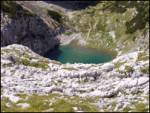 44
44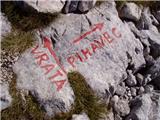 45
45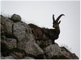 46
46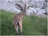 47
47 48
48 49
49 50
50 51
51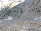 52
52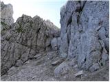 53
53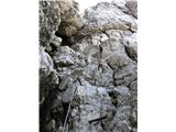 54
54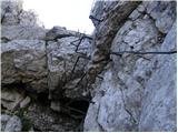 55
55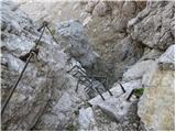 56
56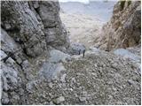 57
57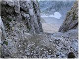 58
58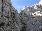 59
59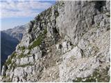 60
60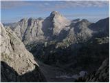 61
61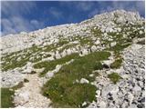 62
62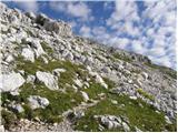 63
63 64
64
Discussion about the trail Zadnjica - Pihavec
|
| metod15. 08. 2012 |
Od Pogačnikovega doma, oziroma od odcepa proti Pihavcu je treba našpičiti oči in iskati markacije, ker pot po škrapljastem terenu ni sledljiva. Se pa v daljavi dobro vidi pot preko melišča in gre do tja tudi prosto "po Prešernu". Naprej ni problemov, je pa skozi grapo res precej krušljivo. Ampak tako je marsikje. Kdor je že prišel do sem, tudi takšne situacije zmore. Razgled pa enkraten: cel kup vrhov in vsaj pet planinskih postojank.
|
|
|
|
| petja19. 08. 2013 |
Včeraj bili gor. Od odcepa proti Pihavcu do melišča so markacije in pot res komaj vidne, orientacijo lajšajo možici. Melišče je v zgornjem delu sitno in naporno. Jeklenice in skobe so v odličnem stanju. Ostalo je že bilo povedano.
|
|
|
|
| darinka422. 07. 2018 |
Ali se sploh vidi postavljeni možic, tam kjer se odcepi pot na Pihovec ?
|
|
|
|
| darinka422. 07. 2018 |
Če greš iz Zadnjice na Luknjo? In potem od Luknje proti Pihavcu?
|
|
|
|
| darinka422. 07. 2018 |
Si bom preslikala , pa bo. Tiste ogromne kozoroge pa mi je Vinko pokazal na slikah, od zadnjič , ko ste bili gor. 
|
|
|
|
| jaka1328. 06. 2019 |
A se kaj ve, kdaj bo pot (če sploh) spet odprta?
|
|
|
|
| darinka428. 06. 2019 |
Zelo krušljivo je tam. Bolje je iti po brezpotju z Luknje. Lani smo našli Miheličevo ploščo in prišli na vrh. Čeprav le po opisu in vsi trije prvič.
|
|
|
|
| Nežk7. 09. 2021 12:08:15 |
Pozdravljeni, morda kdo ve ali je ta pot še vedno zaprta oz. neprehodna?
|
|
|
|
| turbo7. 09. 2021 12:27:02 |
|
|
|
|
| ppegan7. 09. 2021 12:42:54 |
Nežk, ta pot je še vedno zaprta, preverjeno v nedeljo, ko sem naredila obvoz pod Pihavec proti Pogačniku. Poleg tega je pot zelo težko sledljiva, saj je nihče ne vzdržuje, markacije pa so precej zbledele. Glede na to, da je zaprta že par let, bo verjetno tako ostalo tudi v prihodnje.
|
|
|
|
| Nežk7. 09. 2021 13:47:50 |
Hvala za informacije ppegan!
|
|
|
|
| BorStenar19. 11. 2022 19:00:31 |
na peti sliki od zadaj imenovani "na škrbini pot zavije desno" ne vidim poti 
|
|
|